
Poligné
| Poligné | ||
|---|---|---|
|
||
| region | Brittany | |
| Department | Ille-et-Vilaine | |
| Arrondissement | Redon | |
| Canton | Bain de Bretagne | |
| Community association | Brittany Porte de Loire Community | |
| Coordinates | 47 ° 53 ′ N , 1 ° 41 ′ W | |
| height | 12-93 m | |
| surface | 9.24 km 2 | |
| Residents | 1,201 (January 1, 2017) | |
| Population density | 130 inhabitants / km 2 | |
| Post Code | 35320 | |
| INSEE code | 35231 | |
 The new Mairie |
||

Poligné (in Gallo Polinyae , in Breton Polinieg ) is a municipality in the French department of Ille-et-Vilaine in Brittany . It belongs to the canton of Bain-de-Bretagne in the Arrondissement of Redon . It borders Bourg-des-Comptes to the north, Crevin to the northeast, Pancé to the east and Pléchâtel to the south and west . The settlement area is on average almost 70 meters above sea level.
The national route 137 leads through Poligné.
Attractions
See also: List of Monuments historiques in Poligné
- Château du Bois-Glaume, Monument historique
- Saint-Donatien-Saint-Rogatien church
- War memorial
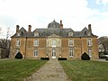
Château du Bois-Glaume

The chapel of the Bois-Glaume castle

Saint-Donatien-Saint-Rogatien church

War memorial


Population development
| year | 1962 | 1968 | 1975 | 1982 | 1990 | 1999 | 2008 | 2013 |
|---|---|---|---|---|---|---|---|---|
| Residents | 430 | 456 | 447 | 492 | 618 | 760 | 1099 | 1140 |
literature
- Le Patrimoine des Communes d'Ille-et-Vilaine. Flohic Editions, Volume 1, Paris 2000, ISBN 2-84234-072-8 , pp. 151-156.
Web links
Commons : Poligné - collection of images, videos and audio files