
Les Brulais
|
Les Brulais ar Brugeier |
||
|---|---|---|
|
||
| region | Brittany | |
| Department | Ille-et-Vilaine | |
| Arrondissement | Redon | |
| Canton | Guichen | |
| Community association | Vallons de Haute-Bretagne Community | |
| Coordinates | 47 ° 53 ' N , 2 ° 3' W | |
| height | 27-91 m | |
| surface | 11.96 km 2 | |
| Residents | 553 (January 1, 2017) | |
| Population density | 46 inhabitants / km 2 | |
| Post Code | 35330 | |
| INSEE code | 35046 | |
 Les Brulais town hall |
||

Les Brulais ( Breton : Ar Brugeier ; Gallo : Lésbroelaè ) is a French municipality with 553 inhabitants (as of January 1 2017) in the department of Ille-et-Vilaine in the region of Brittany . Les Brulais belongs to the Arrondissement of Redon and is part of the canton of Guichen (until 2015: canton of Maure-de-Bretagne ). The inhabitants are called Brulaisiens .
geography
Les Brulais is about 36 kilometers southwest of Rennes . Les Brulais is surrounded by the neighboring communities of Maure-de-Bretagne in the north, south and east, Comblessac in the south-west and Guer in the west and north-west.
| year | 1962 | 1968 | 1975 | 1982 | 1990 | 1999 | 2006 | 2013 |
|---|---|---|---|---|---|---|---|---|
| Residents | 422 | 389 | 382 | 362 | 387 | 400 | 456 | 496 |
Attractions
- Saint-Etienne-Saint-Melaine church, built in 1835
- La Bouère manor

Saint-Etienne-et-Saint-Melaine church
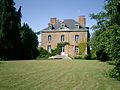
La Bouère manor


literature
- Le Patrimoine des Communes d'Ille-et-Vilaine. Flohic Editions, Volume 2, Paris 2000, ISBN 2-84234-072-8 , pp. 909-911.
Web links
Commons : Les Brulais - Collection of images, videos and audio files