
Lieuron
| Lieuron | ||
|---|---|---|
|
||
| region | Brittany | |
| Department | Ille-et-Vilaine | |
| Arrondissement | Redon | |
| Canton | Redon | |
| Community association | Redon agglomeration | |
| Coordinates | 47 ° 51 ′ N , 1 ° 57 ′ W | |
| height | 18-69 m | |
| surface | 16.71 km 2 | |
| Residents | 785 (January 1, 2017) | |
| Population density | 47 inhabitants / km 2 | |
| Post Code | 35550 | |
| INSEE code | 35151 | |

Lieuron is a commune in Brittany in France . It belongs to the Ille-et-Vilaine department , the Redon arrondissement and the Redon canton ( canton Pipriac until 2015 ). It is bordered by Maure-de-Bretagne to the west and north, Lohéac to the northeast, Guipry-Messac with Guipry to the east and Pipriac to the south . The settlement area is about 35 meters above sea level.
history
Earlier place names were Ludron (11th century), Lurron (1386) and Leuron (1426). The current place name appeared in the (16th century). Lieuron was served by the SNCF on the Châteaubriant – Ploërmel line.
Population development
| year | 1962 | 1968 | 1975 | 1982 | 1990 | 1999 | 2008 | 2013 |
|---|---|---|---|---|---|---|---|---|
| Residents | 608 | 555 | 561 | 526 | 505 | 560 | 694 | 783 |
Attractions
- Cemetery cross, Monument historique
- Notre-Dame-des-Sept-Douleurs church

Cemetery cross
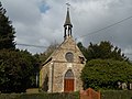
Notre-Dame-des-Sept-Douleurs church


literature
- Le Patrimoine des Communes d'Ille-et-Vilaine. Flohic Editions, Volume 2, Paris 2000, ISBN 2-84234-072-8 , pp. 1032-1035.
Web links
Commons : Lieuron - collection of images, videos and audio files