Sint Maarten
| Sint Maarten | |||||
|
|||||
| Motto : Semper progrediens (Always forward) | |||||
| Official language | Dutch , English | ||||
| Capital | Philipsburg | ||||
| Form of government |
Constitutional monarchy Parliamentary democracy autonomous country within the Kingdom of the Netherlands |
||||
| Head of state |
King Willem-Alexander of the Netherlands represented by |
||||
| Head of government | Silveria Jacobs | ||||
| surface | 34 km² | ||||
| population | 37,132 (January 2014) | ||||
| Population density | 1092 inhabitants per km² | ||||
| currency | Antilles guilder (ANG) | ||||
| National anthem | O sweet Saint-Martin's land | ||||
| Time zone | UTC − 4 | ||||
| ISO 3166 | SX , SXM, 534, NL-SX | ||||
| Internet TLD | .sx | ||||
| Telephone code | +1 721 | ||||
Sint Maarten is an autonomous country within the Kingdom of the Netherlands .
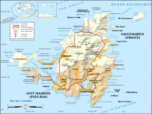
Sint Maarten consists of the southern part of the Caribbean island of St. Martin and a few small uninhabited side islands and rocks (Guana Key, Cow & Calf, Hen & Chickens, Molly Beday and Pelikan Key). The northern part of the island is occupied by the French overseas territory of Saint-Martin .
Cities and settlements
![]() Map with all coordinates: OSM | WikiMap
Map with all coordinates: OSM | WikiMap
| Geozone (district) | Area km² |
Population 2011 |
Coordinates | Sub-districts |
|---|---|---|---|---|
| Philipsburg | ... | 1,327 | 18 ° 1 ′ 28 " N , 63 ° 2 ′ 37" W. | Great Bay |
| Lower Prince's Quarter | ... | 8,143 | 18 ° 3 '10 " N , 63 ° 2' 33" W. | Belvedere, Dutch Quarter, Garden of Eden, Madame's Estate, Middle Region, Mount William Hill, Over the Pond, West Suckergarden |
| Cul de sac | ... | 7,593 | 18 ° 2 '55 " N , 63 ° 3' 53" W. | East Cul-de-Sac, West Cul-de-Sac |
| Cole Bay | ... | 5,594 | 18 ° 2 ′ 25 ″ N , 63 ° 4 ′ 55 ″ W. | Colebay |
| Upper Prince's Quarter | ... | 3.139 | 18 ° 2 '12 " N , 63 ° 1' 48" W. | Dawn Beach, Defiance, East Suckergarden, Guana Bay, Hope Estate, Oysterpond, Pointe Blanche |
| Little Bay (Fort Amsterdam) | ... | 3,093 | 18 ° 1 '45 " N , 63 ° 3' 54" W. | Little Bay |
| Simpson Bay | ... | 596 | 18 ° 2 ′ 9 ″ N , 63 ° 5 ′ 47 ″ W. | Simpson Bay |
| Lowlands | ... | 348 | 18 ° 2 ′ 53 " N , 63 ° 7 ′ 32" W. | Low Lands, Maho Reef |
| not assigned | ... | 3,776 | ... | |
| Sint Maarten | 34 | 33,609 | 18 ° 1 ′ 55 ″ N , 63 ° 4 ′ 4 ″ W. | 22 sub-districts |
Climate table
| Sint Maarten | ||||||||||||||||||||||||||||||||||||||||||||||||
|---|---|---|---|---|---|---|---|---|---|---|---|---|---|---|---|---|---|---|---|---|---|---|---|---|---|---|---|---|---|---|---|---|---|---|---|---|---|---|---|---|---|---|---|---|---|---|---|---|
| Climate diagram | ||||||||||||||||||||||||||||||||||||||||||||||||
| ||||||||||||||||||||||||||||||||||||||||||||||||
|
Average monthly temperatures and rainfall for Sint Maarten
Source: wetterkontor.de
|
|||||||||||||||||||||||||||||||||||||||||||||||||||||||||||||||||||||||||||||||||||||||||||||||||||||||||||||||||||||||||||||||||||||||||||||||||||||||||||||||||||||||||||||||||||||||||||||||||||
population
The native population consists largely of descendants of Dutch settlers and slaves abducted from Africa . Approximately 65% of the population have Dutch citizenship. Among the members of other nations, the citizens of Haiti , the Dominican Republic and Jamaica form the largest population groups, each with more than 5% of the population. Most of the locals are Protestants , especially Pentecostals , Methodists, and Adventists . About a third of the population belongs to the Roman Catholic Church . Smaller population groups profess Hinduism and the Jewish faith.
languages
Most of the population speaks English as their mother tongue. But Spanish, Dutch and Papiamentu are also common.
Constitution and Administration
Until its dissolution, Sint Maarten belonged to the Netherlands Antilles . Since October 10, 2010 it has been one of the Caribbean “lands” (countries) of the Kingdom of the Netherlands. Since then, the Sint Maarten government has consisted of the king represented by a governor , the cabinet made up of the country's ministers and led by the prime minister, and the parliament, which consists of a single chamber , the Staten van Sint Maarten, with 15 members elected for four years. The first states were elected in 2010, the second in 2014.
In the last (early) elections on September 26, 2016, four parties moved into the states :
- United People's Party: 5 seats
- National Alliance: 5 seats
- United St. Maarten Party: 3 seats
- Democratic Party: 2 seats
economy
Sint Maarten is an offshore zone . The companies that are registered on Sint Maarten and do not do business in the Dutch part of the island are tax exempt. Furthermore, there are no property or capital gains taxes . The value added tax is five percent.
The gross domestic product of Sint Maarten in 2013 was 1825 million Antillean guilders (approximately one billion US dollars). Important industries are the real estate sector, trade, transport, tourism and financial services.
currency
The official currency is the Antillean guilder ; due to the fixed exchange rate, payments can usually also be made in the US dollar . With the dissolution of the Netherlands Antilles in 2010 , the end of the Antilles guilder was decided. For the special communities of Bonaire , Saba and Sint Eustatius , the national currency was replaced by the US dollar on January 1, 2011.
At the end of August 2009, at a conference in Willemstad with experts, dollarization was also discussed for Curaçao and Sint Maarten . In 2012 it was decided to replace the Antilles guilder with the Caribbean guilder , but not yet implemented. Instead of the 25 and 250 Antilles guilder banknotes, there will then be banknotes of 20 and 200 Caribbean guilders. The euro is also often accepted in the tourism industry.
Tourism and infrastructure
With Port St. Maarten in Philipsburg, Sint Maarten has a port where cruise ships can dock. In the season this is up to six ships per day. A special feature that makes the island particularly attractive to tourists is the status of the free port, which means that neither taxes nor customs are levied. As a result, a real tobacco and spirits tourism developed. However, as soon as the last ships cast off around 6 p.m., Philipsburg, for example, looks like deserted.
The southwest part of the island is quite narrow. There is the Princess Juliana International Airport , which divides the southern of the two land bridges, directly on the coast . It was renewed in 2006 and, among other things, received a new terminal. The special thing is that the landing aircraft (including wide- bodied aircraft such as the Airbus A340 or the Boeing 747 ) fly just a few meters above the heads of the vacationers due to the proximity of the runway to the beach. The beach is open to tourists and has warning notices. Tourists can stand right under the planes and take photos of them. To inform the onlookers, a sign with landing times, airlines, machines and departure locations is updated daily at the restaurant on the beach next to the runway. In July 2017, a tourist was killed in impact with a concrete block; it had been torn from the fence by the thrust of the engine of a plane taking off.
Current information from the region is distributed worldwide via two internet radio stations. These are the channels The Voice of St. Maarten and Pearl of the Caribbean .
Attractions
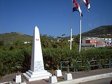
- the border monument commemorating the Treaty of Concordia in 1648 and the partition of the island,
- the history museum in Philipsburg,
- the beach Maho Beach on the runway threshold at Princess Juliana Airport,
- Fort Amsterdam and Fort Williams near Philipsburg,
- the Loterie Farm Flyzone.
Picture gallery
Country Ender Airbus A340 of Air France
See also
Web links
- Sintmaartengov.org. Official website of the government of Sint Maarten.
Individual evidence
- ↑ Makini K. Hickinson (Ed.): Statistical Yearbook 2014 . Department of Statistics Sint Maarten, Philipsburg 2014, 2nd population, p. 17 , 2.1 Population of Sint Maarten, January 1st (English, accessible online on the website of the Department of Statistics Sint Maarten [PDF; 2,3 MB ; accessed on November 10, 2017]).
- ↑ PL 429 Sint Maarten. (PDF; 26 kB) In: nationalnanpa.com. North American Numbering Plan Administration (NANPA), November 1, 2011, accessed November 10, 2017 .
- ↑ Population by geographic region by local- and foreign-born. In: Census 2011 Demography tables. Department of Statistics Sint Maarten, accessed November 10, 2017 .
- ↑ Humdata: Sint Maarten
- ↑ Population by nationality, age and sex. In: Census 2011 Demography tables. Department of Statistics Sint Maarten, accessed November 10, 2017 .
- ↑ Population by religion, age and sex. In: Census 2011 Demography tables. Department of Statistics Sint Maarten, accessed November 10, 2017 .
- ↑ Waaruit confirms the Koninkrijk der Nederlanden? In: Caribisch deel van het Koninkrijk. Rijksoverheid voor Nederland, accessed November 10, 2017 (Dutch).
- ^ State regulation of Sint Maarten . Constitution of the country of Sint Maarten. In: Afkondigingsblad van Sint Maarten . Born 2010, December 20, 2010, Hoofdstuk 3: De Regering en de Gevolmachtigde Minister - Hoofdstuk 4: De Staten , p. 8–16 (Dutch, online on the website of the Parliament of Sint Maarten [PDF; 257 kB ; Retrieved November 10, 2017] Articles of the Constitution on the government and parliament of the area).
- ↑ Parliament Elections September 26, 2016 - Sint Maarten - Final. (PDF; 67 kB) Official election result. Government of Sint Maarten, October 5, 2016, accessed November 10, 2017 .
- ↑ Makini K. Hickinson (Ed.): Statistical Yearbook 2014 . Department of Statistics Sint Maarten, Philipsburg 2014, 12. National Accounts, p. 60 , 12.1 Gross Domestic Product by Sector and Industry (English, accessible online on the website of the Department of Statistics Sint Maarten [PDF; 2,3 MB ; accessed on November 10, 2017]).
- ↑ How does the conversion to the US dollar work? In: Frequently asked questions. De Nederlandsche Bank - Bonaire, Sint Eustatius, Saba, archived from the original on July 20, 2011 ; accessed on November 10, 2017 (English).
- ↑ What has changed, are the national herindeling van het Koninkrijk der Nederlanden? Verandering munteenheid Caribisch Nederland. In: Documents en publicaties - Questions en answers. Rijksoverheid voor Nederland, archived from the original on March 20, 2012 ; Retrieved November 10, 2017 (Dutch).
- ↑ Esther Schalkwijk: Biljetten van 25 verdwijnen. In: Versgeperst.com. September 30, 2010, archived from the original on January 5, 2013 ; Retrieved November 10, 2017 (Dutch).
- ^ Port St. Maarten: Home. In: Port St. Maarten. Port St. Maarten - Group of Companies, accessed November 10, 2017 .
- ↑ Stefan Eiselin: Accident at Maho Beach: How much to blame is St. Maarten Airport? In: aerotelegraph.com. aeroTELEGRAPH GmbH, July 17, 2017, accessed on November 10, 2017 .
- ↑ Homepage PJD2Radio.com , accessed on October 20, 2015
- ↑ Homepage 98.1 Pearl FM Radio , accessed on October 20, 2015
Coordinates: 18 ° 2 ′ N , 63 ° 4 ′ W


