Steinkopf (Taunus)
| Stone head | ||
|---|---|---|
|
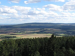
View from the Hausberg tower south-southeast to the |
||
| height | 518 m above sea level NHN | |
| location | near Ober-Rosbach , Pfaffenwiesbach ; Wetteraukreis , Hochtaunuskreis ; Hessen ( Germany ) |
|
| Mountains | Taunus | |
| Dominance | 10.17 km → North-east slope Roßkopf | |
| Notch height | 173 m ↓ Sattel at the Löwenheck farm in Wehrheim | |
| Coordinates | 50 ° 19 '37 " N , 8 ° 39' 38" E | |
|
|
||
| particularities | - Telecommunication tower - Winterstein tower ( AT ) |
|

The Steinkopf near Ober-Rosbach in the Wetteraukreis and Pfaffenwiesbach in the Hochtaunuskreis in Hesse is 518 m above sea level. NHN high mountain in the eastern Taunus and the easternmost Taunus elevation over 300 m . With a dominance of 10.170 km and a prominence of 173 m, it is one of the five most independent peaks in the Taunus. In particular, for the immediately subsequent east Wetterau the stone head forms a highly visible landmark .
There are several mountains of the same name in the Taunus, see Steinkopf .
geography
location
The Steinkopf rises in the Taunus Nature Park between Ober-Rosbach , which belongs to Rosbach vor der Höhe in the Wetterau district, and the village of Pfaffenwiesbach , which belongs to Wehrheim in the Hochtaunus district ; the border between the two circles runs around 200 m northwest of the summit of the wooded Steinkopf. The summit is located in the Wetterau district 3.3 km northwest of Ober-Rosbach, 4.2 km west of the Friedberg district of Ockstadt , on whose boundary it lies, and 3.7 km east of Pfaffenwiesbach.
The mountain spur Winterstein ( 482.3 m ) lies around 850 m north-northeast of the summit and the Dachskopf ( 512.6 m ) 400 m south of the summit . Upstream of the latter are the Mainzer Kopf ( 420.9 m ) in the south-east and the Kuhkopf (approx. 500 m ) in the south-west , about 1 km away . They all belong to the Steinkopf massif.
The Holzbach rises on the western flank of the Steinkopf and the Seebach on its northeast flank , both of which flow into the United States. In addition, the weather tributary Straßbach rises on the east flank and the Rosbach tributary Fahrenbach on the south-southeast flank of the Dachskopf .
The lower part of the eastern flank of the Steinkopf is passed by the A5 , between the Wetterau service station and the Friedberg junction . Especially for traffic coming from the north, the Steinkopf is a striking landmark from the Gambacher Kreuz .
Natural allocation
The Steinkopf belongs to the natural spatial main unit group Taunus (No. 30) and in the main unit Hoher Taunus (301) to the subunit Winterstein-Taunuskamm (301.4). In the same main unit, the subunits Johannisberg-Taunus (301.5) in the northeast and Feldberg-Taunuskamm (301.3) in the southwest.
Impact crater
According to investigations of a team at the University of Marburg could between the stone head and the 2.7 km south-southeast located in the upper-Rosbach Salzberg ( 341.1 m a) meteorite be descended, in particular the one impact crater similar to Valley of the driving Bach could have made. A detailed geological examination of rock samples, however, did not reveal any evidence of an impact metamorphosis , only quartzite with the usual deformations caused by mountain formation.
use
Limes with forts
The Upper Germanic-Raetian Limes runs on the western flank of the Steinkopf with the Kaisergrube fort in the northwest and the Ockstädter Wald and Kapersburg forts near the Kuhkopf .
Telecommunications tower
On the summit region of the Steinkopf there is a 105.35 m high telecommunications tower ( type tower ), which can be seen from Frankfurt am Main via the Wetterau to the Vogelsberg in good weather . The tower, which went into operation in 1972, was originally also used as a television transmitter, but today it only serves as a directional and mobile radio system.
military
An area on the southwest flank has been used as an ammunition storage facility since 1949 , initially by the armed forces of the United States and since 1997 by the German Armed Forces . An area of 3200 ha on the north side was planned as a military training area, but only 70 ha were used. In the meantime, 59.44 ha of this on the Eichkopf, northeast of the Winterstein, have been designated as a fauna and flora habitat (FFH no. 5617-302). At what will later be the northern edge of the square, there were bunkers for the FHQ Adlerhorst , and two US Army depots to the northeast and southeast of the square.
Quarry
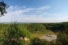
On the southeast slope of the southwest to the stone head and also close to Ober-Rosbach Saukopfs a was quartzite - quarry from which parts since 2010 as a nature reserve quartzite quarry in Rosbach ( CDDA , are reported -No 555514019 5.14 ha.).
Mining
Starting and amplified in Roman times in the 19th century mining on lead and silver operation, see Old imperial pit .
Winter stone
location
The Winterstein ( ⊙ ) is a 482.3 m high spur about 850 m north-northeast of the Steinkopf summit , which does not stand out from the Steinkopf when viewed from the low-lying Wetterau; it is located 3.8 km west of Ockstadt in the municipality of Ober-Mörlen . In the area, the whole Steinkopf massif is often referred to as the Winterstein . Only this spur is shown on many maps, although it is lower than the Steinkopf summit.
Winterstein Tower
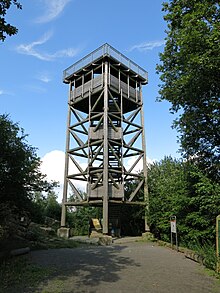
As early as 1888, a small wooden observation tower was built on the Winterstein by the Taunusklub Wetterau . Around 1920, the Hessisches Staatsbad built a new wooden tower, which was raised by one floor in 1960. In 2004 this was demolished due to dilapidation. A citizens' initiative made up of citizens of Ober-Mörler , Bad Nauheim and Friedberg, as well as various donations from companies, institutions, etc., succeeded in building a new, higher , five-storey wooden tower (17.65 m) with two viewing platforms made entirely of Douglas fir - called Winterstein . The topping-out ceremony took place on May 1, 2005 and the tower was inaugurated on July 3, 2005.
Its lower viewing platform, at a height of 13.9 m, can be reached via 4 concrete and 71 metal steps, the upper platform at 16.73 m after another 14 metal steps. The square upper platform has an edge length of 6.7 m and is bordered with a 1.15 m high metal parapet. From there, the view falls from a height of 498.41 m to the northwest to the Westerwald , to the north to the Gladenbacher Bergland , to the east to the Wetterau and, beyond it, to the Vogelsberg , to the southeast to the Spessart and to the south to Frankfurt am Main and beyond away, to the Odenwald . When visibility is very good, it extends in the north to the Rothaargebirge , in the north-northeast to the Kellerwald , in the northeast to the Knüllgebirge , in the east to the Rhön and in the south to the Black Forest 150 km away .
tourism
Located on the northern slope of Steinkopf and Winterstein ultimately on the Wintersteinstraße to reach hikers parking Winterstein (about 335 m ), which is signposted from the industrial area of Upper Mörlen. The European long-distance hiking trail E3 crosses the Limes to the west, past the Steinkopf . Starting in Pfaffenwiesbach to the west, through the valley of the Wiesbach to the Kapersburg fort on the Limes, and continuing through the forest past Kuhkopf (approx. 500 m ) and Dachskopf 512.6 m , the mountain summit is easily accessible.
The approximately 7 km long wildcat forest adventure trail runs over the Winterstein . The circular route set up by BUND begins and ends at the Winterstein hikers' car park . It leads past the Winterstein observation tower . On the path, which is laid out on narrow trails in many places, about 190 meters of altitude have to be overcome.
See also
References and comments
- ↑ a b c Map services of the Federal Agency for Nature Conservation ( information )
- ↑ Summit in the Taunus by dominance and prominence , on thehighrisepages.de
- ↑ Brigitte Schwenzer: Geographical land survey: The natural space units on sheet 139 Frankfurt a. M. Federal Institute for Regional Studies, Bad Godesberg 1967. → Online map (PDF; 4.9 MB)
- ↑ Ring structure discovered on Taunus ridge, meteorite crater near Rosbach? , on oberrheingraben.de
- ↑ Radio signals from the crater rim , from January 28, 2012, accessed on September 9, 2015, on fr-online.de
- ↑ Nature takes back the winter stone , article in the Wetterauer Zeitung, October 10, 2008, accessed on September 9, 2015, on wetterauer-zeitung.de
- ↑ a b c Welcome to the Winterstein Tower with facts and figures , photo of the information board on the tower, on commons.wikimedia.org
- ↑ a b c Height information above the paved floor slab according to privately carried out measurements (afterwards the upper viewing platform is at 16.5 m tower height)
- ↑ Annette Hausmanns: Hundreds of visitors celebrate the 10th birthday of the Winterstein Tower with a mountain service in Ober-Mörlen - building with symbolic power , Wetterauer Zeitung, No. 160, p. 24, July 15, 2015, accessed on July 28, 2015, on bistummainz.de
- ↑ Sign on the Winterstein Tower, on mw2.google.com
- ↑ The WILD CATS forest experience - the adventure trail on the Winterstein im Hochtaunus , bund-hessen.de
Web links
- View from the Winterstein Tower (labeling of visual targets can be activated), on panorama-photo.net


