
Rimbach (Upper Palatinate)
| coat of arms | Germany map | |
|---|---|---|

|
Coordinates: 49 ° 14 ' N , 12 ° 53' E |
|
| Basic data | ||
| State : | Bavaria | |
| Administrative region : | Upper Palatinate | |
| County : | Cham | |
| Height : | 488 m above sea level NHN | |
| Area : | 24.73 km 2 | |
| Residents: | 1824 (Dec. 31, 2019) | |
| Population density : | 74 inhabitants per km 2 | |
| Postal code : | 93485 | |
| Area code : | 09941 | |
| License plate : | CHA, KÖZ, ROD , WÜM | |
| Community key : | 09 3 72 151 | |
| Community structure: | 18 districts | |
| Address of the municipal administration: |
Hohenbogenstrasse 10 93485 Rimbach |
|
| Website : | ||
| Mayor : | Heinz Niedermayer ( CSU ) | |
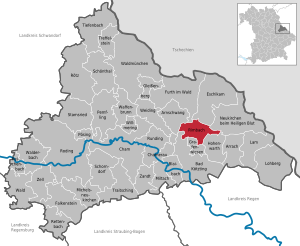
| Location of the municipality of Rimbach in the district of Cham | ||
  |
||

Rimbach is a municipality in the Upper Palatinate district of Cham .
Community structure
Rimbach has 18 districts:
|
The following districts exist in the municipality : Gotzendorf, Hoher Bogen, Rimbach, Thenried, Zenching. The Gotzendorf district is shared with the neighboring municipality of Hohenwarth , the Zenching district is shared with the municipality of Arnschwang .

history
Until the church is planted
The castle Lichteneck was originally the center of a Hofmark to large parts of today's municipal area belonged. The Pelkofen had a new Schlössl built below the castle ruins and the local parish church built in 1719. Rimbach became a parish for the first time in 1808.
19th and 20th centuries
With a law passed on May 28, 1852, the municipality received the status of a public corporation for the first time and could be described as a municipality in the current sense.
Rimbach barely played a role during World War II . There is only one incident that could be described as a combat operation, namely when in 1945 two members of the Waffen SS resisted the advancing US soldiers and were shot by them.
High arch
During the Cold War, the "mountain" Rimbachs who served High arch from 1957, as the site of a NATO - listening post . In addition to members of the Bundeswehr , US units were stationed there until 1993 and French units until 1994 . The German part of the plant was finally shut down in 2004. The two telecommunications towers , however, are still on a summit of the Hohen Bogen, the corner stone. They were acquired in 2008 by an investor who, since 2014, has had one of the towers converted into a viewing platform for tourist purposes with the help of a support association founded for this purpose.

In addition, the Hohe Bogen has served as the location of a transmission system for Bavarian Broadcasting since 1952 . Until 1961, a 30 meter high, free-standing steel lattice tower was used, which was replaced in 1961 by today's 75 meter high reinforced concrete tower. In 2007, two components weighing around three to four tons were replaced by more stable parts due to errors and imbalances, using a cargo helicopter.
Incorporations
On January 1, 1972, the previously independent community of Thenried and part of the former community of Gotzendorf were incorporated. On July 1, 1972, parts of Zenching were added. The Thenried district was an independent municipality from 1852 to 1972 and was voluntarily incorporated into the neighboring municipality during the regional reform .
On January 1, 1972, the community of Gotzendorf was divided into the communities Hohenwarth (main part, then a little more than 400 inhabitants) and Rimbach (then about 70 inhabitants). The community of Zenching was dissolved on July 1, 1972. More than 300 residents moved to Arnschwang, around 80 residents to Rimbach.
Population development
Between 1988 and 2018, the population decreased from 1,919 to 1,821 by 98 inhabitants or 5.1%.
politics
Mayors and parties
Mayor since May 1, 2020 is Heinz Niedmayer ( CSU ); he was elected on March 15, 2020 with 88.0% of the valid votes. His predecessor was Ludwig Fischer (CSU) from May 2014 to April 2020. Its predecessor was Theo Amberger ( CSU ) since 1990 . There are two political groups in Rimbach: a CSU and an SPD local association.
Municipal council
The election on March 15, 2020 resulted in the following distribution of votes and seats in the municipal council:
| Seats | Share of votes | |
|---|---|---|
| CSU | 3 | 28.8% |
| Free citizens of Rimbach | 3 | 21.5% |
| unity | 2 | 15.5% |
| Free electorate | 2 | 19.6% |
| Independent electoral association | 2 | 14.5% |
| total | 12 | 100.0% |
The turnout was 63.0%.
coat of arms
The description reads: “In blue a slanted golden flaming sword with a silver handle, in the upper right corner a little label, split from red and silver, in front a silver bar.” The coat of arms has been in use since 1982.
Parish
The parish of Rimbach with the Zenching branch belongs to the diocese of Regensburg .
Architectural monuments
economy
Jobs and agriculture
In 2017 there were 252 jobs subject to social security contributions in the municipality. Of the resident population, 770 people were in employment that required insurance. This means that the number of out-commuters was 518 more than that of in-commuters. 27 residents were unemployed. In 2016 there were 25 farms; 684 hectares of the community area were used for agriculture.
education
The community has the following institutions:
- Day care center with 52 places and 38 supervised children (March 1, 2018)
- Hohen-Bogen elementary school with three teachers and 55 students.
literature
- Harald Stark : The Notthracht family - looking for traces in Egerland, Bavaria and Swabia. Weißenstadt 2006, ISBN 3-926621-46-X .
Individual evidence
- ↑ "Data 2" sheet, Statistical Report A1200C 202041 Population of the municipalities, districts and administrative districts 1st quarter 2020 (population based on the 2011 census) ( help ).
- ↑ bayerische-landesbibliothek-online.de
- ↑ br.de ( Memento from May 22, 2014 in the Internet Archive )
- ^ Wilhelm Volkert (ed.): Handbook of Bavarian offices, communities and courts 1799–1980 . CH Beck, Munich 1983, ISBN 3-406-09669-7 , p. 499 .
- ^ Federal Statistical Office (ed.): Historical municipality directory for the Federal Republic of Germany. Name, border and key number changes in municipalities, counties and administrative districts from May 27, 1970 to December 31, 1982 . W. Kohlhammer, Stuttgart / Mainz 1983, ISBN 3-17-003263-1 , p. 612 .
- ↑ gemeinde-rimbach.de
- ↑ Mittelbayerische.de
- ↑ 2020 municipal council election , accessed on August 17, 2020
- ↑ Michael Boger - www.wedebo.de: parish Rimbach & Expositur Zenching - history. In: www.pfarrei-rimbach.de. Retrieved May 18, 2016 .
- ^ Hohenbogen Primary School Rimbach in the school database of the Bavarian State Ministry for Education and Culture , accessed on August 17, 2020.
Web links
- Entry on the coat of arms of Rimbach (Upper Palatinate) in the database of the House of Bavarian History

Arnschwang | Arrach | Bad Kötzting | Blaibach | Cham | Chamerau | Eschlkam | Falkenstein | Furth in the forest | Gleißenberg | Grafenwiesen | Hohenwarth | Lam | Lohberg | Michelsneukirchen | Miltach | Neukirchen near the Holy Blood | Pemfling | Pösing | Reichenbach | Rettenbach | Rimbach | Roding | Rötz | Rounding | Schönthal | Schorndorf | Stamsried | Tiefenbach | Traitsching | Treffelstein | Weapon Well | Forest | Walderbach | Waldmünchen | Weiding | Willmering | Zandt | Cell