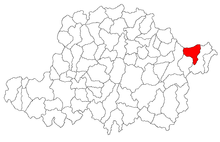
Vârfurile (Arad)
|
Vârfurile, Ciuci Tschutsch Halmágycsúcs |
||||
|
||||
| Basic data | ||||
|---|---|---|---|---|
| State : |
|
|||
| Historical region : | Screeching area | |||
| Circle : | Arad | |||
| Coordinates : | 46 ° 18 ' N , 22 ° 32' E | |||
| Time zone : | EET ( UTC +2) | |||
| Area : | 136 km² | |||
| Residents : | 2,715 (2011) | |||
| Population density : | 20 inhabitants per km² | |||
| Postal code : | 317390 | |||
| Telephone code : | (+40) 02 57 | |||
| License plate : | AR | |||
| Structure and administration (as of 2016) | ||||
| Community type : | local community | |||
| Structure : | Vârfurile, Avram Iancu , Groși , Lazuri , Măgulicea , Mermești , Poiana , and Vidra | |||
| Mayor : | Radu-Tiberiu Giurgelea ( PNL ) | |||
| Postal address : | Str. Primăriei No. 286 loc. Vârfurile, jud. Arad, RO-317390 |
|||
| Website : | ||||
Vârfurile (until 1926: Ciuci , German: Tschutsch , Hungarian: Halmágycsúcs ) is a municipality in the Arad district , in the Kreisch area , in western Romania . The villages of Avram Iancu , Groși , Lazuri , Măgulicea , Mermeşti , Poiana , and Vidra also belong to the municipality of Vârfurile .
Geographical location
Vârfurile is located at the foot of the Codru-Moma Mountains in the Bihor Mountains , on the Crișul Alb , 128 km from the district capital Arad .
Neighboring places
| Vidra | Mǎgulicea | Lazuri |
| Pleșcuța |

|
Luncșoara |
| Dumbrava | Leasa | Halmagiu |
history
The village was first mentioned in 1390 under the place name Chich . Remains of an earth fortress from the 8th – 9th centuries were found on the area of the community. Century found.
In 1427 the place appears under the name Chuch in the contemporary documents. In the years 1439, 1441 and 1445 Choch and Chaul belonged to the Șiria fortress . The place name Czotz appears in 1590. Over the centuries the landowners changed several times: 1439 Brancovici, 1441 Marothy, 1442 Berini, 1444 Hunyadi , 1447 Banffy, 1510 Georg von Brandenburg , 1551 Kendy, 1494 Corvinus and Banffy.
After the Peace of Karlowitz (1699), Arad and the Maroscher Land came under Austrian rule , while the Banat south of the Marosch remained under Turkish rule until the Peace of Passarowitz (1718) .
As a result of the Austro-Hungarian Compromise (1867), the Arad region, like the whole of Banat and Transylvania, was annexed to the Kingdom of Hungary within the Austro-Hungarian dual monarchy . The official place name was Halmágycsúcs .
The Treaty of Trianon on June 4, 1920 resulted in the regulation of borders , whereby Ciuci fell to the Kingdom of Romania . In 1926 the village was renamed Vârfurile .
Population development
| census | Ethnicity | |||||||
|---|---|---|---|---|---|---|---|---|
| year | Residents | Romanians | Hungary | German | Other | |||
| 1880 | 4024 | 3964 | - | 4th | 56 | |||
| 1910 | 6001 | 5881 | 97 | 8th | 15th | |||
| 1930 | 5556 | 5525 | 19th | 8th | 4th | |||
| 1977 | 4431 | 4426 | 3 | - | 2 | |||
| 1992 | 3738 | 3715 | 3 | - | 20th | |||
| 2002 | 3298 | 3261 | 2 | 1 | 34 | |||
Web links
- ghidulprimariilor.ro , Vârfurile on the Arad County Council website
- virtualarad.net , Vârfurile on VirtualArad
Individual evidence
- ↑ citypopulation.de , census October 20, 2011
- ↑ Mayoral elections 2016 in Romania ( MS Excel ; 256 kB)
- ↑ kia.hu , E. Varga: Statistics of the population by ethnic group in the Arad district according to censuses from 1880 - 2002


