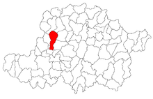
Șimand
|
Șimand Schimand Alsósimánd |
||||
|
||||
| Basic data | ||||
|---|---|---|---|---|
| State : |
|
|||
| Historical region : | Screeching area | |||
| Circle : | Arad | |||
| Municipality : | Șimand | |||
| Coordinates : | 46 ° 26 ' N , 21 ° 27' E | |||
| Time zone : | EET ( UTC +2) | |||
| Area : | 100.28 km² | |||
| Residents : | 3,982 (2011) | |||
| Population density : | 40 inhabitants per km² | |||
| Postal code : | 317335 | |||
| Telephone code : | (+40) 02 57 | |||
| License plate : | AR | |||
| Structure and administration (as of 2016) | ||||
| Community type : | local community | |||
| Structure : | Șimand | |||
| Mayor : | Florin-Liviu Dema ( PSD ) | |||
| Postal address : | Str. Principală, no. 1119 loc. Șimand, jud. Timiș, RO-317335 |
|||
| Website : | ||||
Șimand ( German Schimand , Hungarian Alsósimánd ) is a municipality in the Arad district , Kreischgebiet , Romania .
Geographical location
Șimand is located on Drum național 79 between Arad and Chișineu-Criș , 30 kilometers northeast of the district capital Arad.
Neighboring places
| Șiclău | Socodor | Nadab |
| Sânmartin |

|
Cintei |
| Macea | Sântana | Olari |
history
The place Symand was first mentioned in 1274. In a document from 1403 Schimand is listed as an "oppidum".
In 1725 the community passed into the possession of the Edelspacher family, who until 1889 had a significant influence on the development of the village. The Arad prefect and camera administrator Sigismund Edelspacher bought the goods Schimand, Matscha , Gyorok and Lökösháza as “mixta donatio” in 1725 . The purchase price was 12,908 Rhenish guilders .
The German population was called to Schimand by the landlords Edelspacher around 1800 as part of the private settlement . These came from localities in the vicinity: Elek , Aradsanktmartin and Sanktanna .
From 1717 to 1920 the municipality belonged to the Kingdom of Hungary , Arad County . The official name was Alsósimánd . After the Banat was divided into three on June 4, 1920 as a result of the Treaty of Trianon , the municipality fell to the Kingdom of Romania . Since then, the official name has been Șimand .
Demographics
| census | Ethnicity | |||||||
|---|---|---|---|---|---|---|---|---|
| year | Residents | Romanians | Hungary | German | Other | |||
| 1880 | 4030 | 2594 | 978 | 433 | 25th | |||
| 1910 | 5228 | 3486 | 1154 | 563 | 25th | |||
| 1930 | 4693 | 3336 | 682 | 600 | 75 | |||
| 1977 | 4657 | 3674 | 413 | 367 | 203 | |||
| 1992 | 4049 | 3521 | 252 | 85 | 191 | |||
| 2002 | 4144 | 3615 | 197 | 37 | 295 | |||
Attractions
- Cernovici castle with park
- Orthodox Church (built in 1759)
literature
- Elke Hoffmann, Peter-Dietmar Leber and Walter Wolf : The Banat and the Banat Swabians. Volume 5. Cities and Villages , Media Group Universal Grafische Betriebe München GmbH, Munich, 2011, 670 pages, ISBN 3-922979-63-7 .
Web links
- ghidulprimariilor.ro , Șimand Citizens' Office
- virtualarad.net , Șimand on VirtualArad.
Individual evidence
- ↑ citypopulation.de , 2011 census
- ^ A b c Elke Hoffmann, Peter-Dietmar Leber and Walter Wolf : The Banat and the Banat Swabians. Volume 5. Cities and Villages , Media Group Universal Grafische Betriebe München GmbH, Munich, 2011, 670 pages, ISBN 3-922979-63-7
- ↑ kia.hu , E. Varga: Statistics of the population by ethnic group in the Arad district according to censuses from 1880 - 2002
- ↑ a b simand.org ( Memento of March 22, 2015 in the Internet Archive ), Kultur Șimand


