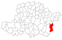
Petriș (Arad)
|
Petriș Petrisch Marospetres, Petris |
||||
|
||||
| Basic data | ||||
|---|---|---|---|---|
| State : |
|
|||
| Historical region : | Screeching area | |||
| Circle : | Arad | |||
| Coordinates : | 46 ° 3 ' N , 22 ° 23' E | |||
| Time zone : | EET ( UTC +2) | |||
| Area : | 130.59 km² | |||
| Residents : | 1,525 (2011) | |||
| Population density : | 12 inhabitants per km² | |||
| Postal code : | 317245 | |||
| Telephone code : | (+40) 02 57 | |||
| License plate : | AR | |||
| Structure and administration (as of 2016) | ||||
| Community type : | local community | |||
| Structure : | Petriș, Corbești , Ilteu , Obârșia , Roșia Nouă and Seliște | |||
| Mayor : | Onescu Irina | |||
| Postal address : | Str. Principală No. 253 loc. Petriș, jud. Arad, RO-317245 |
|||
| Website : | ||||
Petriș (German: Petrisch , Hungarian: Marospetres , Petris ) is a municipality in the Arad district , in the Kreisch area , in western Romania . The Petriş municipality also includes the villages of Corbeşti , Ilteu , Obârşia , Roşia Nouă and Selişte .
Geographical location
Petriș is located in the southeast of Arad County, on the border with Hunedoara County , 106 km from the county capital Arad .
Neighboring places
| Troaș | Corbeşti | Almășel |
| Temeşeşti |

|
Almaş-Sălişte |
| Zam | Selişte | Toc |
history
The village of Petris was first mentioned in a document in 1337. The current village of Petrisch was founded in 1743 by relocating the old one. Over the centuries, different spellings of the place name appeared: 1743 Petrisch , 1808 Petris , 1839, 1847 Petris , 1858–1900 Petris , 1909 Petriş , Petris , 1913 Marospetres , 1921 Petriş , Marospetres , 1925 Petriş , 1950 Petriş .
After the Peace of Karlowitz (1699), Arad and the Maroscher Land came under Austrian rule , while the Banat south of the Marosch remained under Turkish rule until the Peace of Passarowitz (1718) . On the Josephine land survey is Petris entered.
The historical documents from 1778 show that the estate belonged to the Salbeck family. The Salbeck family was a German Catholic aristocratic family who provided the salt collector from Hunedoara around 1733 . After the suppression of the peasant uprising of 1784 , Count Salbeck had the village of Petrisch relocated with all its houses in the immediate vicinity of the fort, where it is still located today. Count Salbeck had the fort renovated and rebuilt in the neoclassical style , and the 18.8 hectare park was laid out.
As a result of the Austro-Hungarian Compromise (1867), the Arad region, like the whole of Banat and Transylvania, was annexed to the Kingdom of Hungary within the Austro-Hungarian dual monarchy . The official place name was Marospetres .
The Treaty of Trianon on June 4, 1920 resulted in border regulation, whereby Petriș fell to the Kingdom of Romania .
Population development
| census | Ethnicity | |||||||
|---|---|---|---|---|---|---|---|---|
| year | Residents | Romanians | Hungary | German | Other | |||
| 1880 | 4844 | 4757 | 64 | 16 | 7th | |||
| 1910 | 5131 | 4960 | 108 | 49 | 14th | |||
| 1930 | 4295 | 4220 | 28 | 20th | 27 | |||
| 1977 | 2335 | 2332 | 2 | 1 | - | |||
| 1992 | 2020 | 2006 | 9 | 4th | 1 | |||
| 2002 | 1871 | 1855 | 10 | - | 6th | |||
Web links
- ghidulprimariilor.ro , Petriș Citizens Registration Office
- virtualarad.net , Petriș on VirtualArad
Individual evidence
- ↑ citypopulation.de , census October 20, 2011
- ↑ Mayoral elections 2016 in Romania ( MS Excel ; 256 kB)
- ↑ a b arcanum.hu , Petriș, Arad
- ↑ actualitati-arad.ro , Salbeck Castle
- ↑ kia.hu , E. Varga: Statistics of the population by ethnic group in the Arad district according to censuses from 1880 - 2002


