Almaș (Arad)
|
Almaș Almasch Háromalmás |
||||
|
||||
| Basic data | ||||
|---|---|---|---|---|
| State : |
|
|||
| Historical region : | Screeching area | |||
| Circle : | Arad | |||
| Coordinates : | 46 ° 17 ' N , 22 ° 14' E | |||
| Time zone : | EET ( UTC +2) | |||
| Height : | 150 m | |||
| Area : | 81.27 km² | |||
| Residents : | 2,532 (October 20, 2011) | |||
| Population density : | 31 inhabitants per km² | |||
| Postal code : | 317005 | |||
| Telephone code : | (+40) 02 57 | |||
| License plate : | AR | |||
| Structure and administration (as of 2016) | ||||
| Community type : | local community | |||
| Structure : | Almaş, Cil , Joia Mare , Rădeşti | |||
| Mayor : | Teodor Avram ( PNL ) | |||
| Postal address : | Str. Principală, no. 605 loc. Almaș, jud. Arad, RO-317005 |
|||
| Website : | ||||
Almaș (German: Almasch , Hungarian: Háromalmás ) is a municipality in the Arad district in the Romanian Kreischgebiet .
The place is also known under the German name Almasch and the Hungarian Alsóalmás , Felsőalmás , Kisalmás , Nagyalmás and Almás .
Geographical location
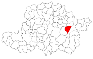
The municipality of Almaș is located in the northern foothills of the Zarand Mountains ( Munții Zarandului ) - a mountain range of the Apuseni Mountains - south of the Crișul Alb ( White Screech ). The place Almaş, at the same Bach - a left tributary of the White Kreischberg , the - drum naţional 79A ( Vârfurile - Varsand ) and the railway Arad-Brad , is located in the historic chair District Borossebes the county Arad 39 km southeast of the town of Ineu ; the district capital Arad is located 96 kilometers (71 km as the crow flies) west of Almaş.
history
The place Almaș was first mentioned in 1334.
It is named after Dominicus de Almos. In the course of the centuries different spellings of the place name appeared: 1334 Almos , 1406 Alsoalmas , 1439 Almas , 1441 Felsewalmas , 1445 Also Almas , 1479 Haromalmos , 1525 Nagh Almas , Kys Almas , 1715 Almás , 1808 Almás , 1839 Almás , 1858-1900 Almás , 1909 Almaş , Almás , 1910, 1913 Háromalmás , 1921 Almaş , Háromalmás , 1932, 1956 Almaş .
On the area of the incorporated village of Cil (ung. Alcsil ) finds were made which, according to S. Márki and M. Roska, point to the Late Bronze Age . These are now in the museum in Budapest .
Today the residents live mainly from cattle breeding, agriculture, fruit growing and mainly wood processing.
population
The population of the municipality developed as follows:
| census | Ethnic composition | |||||||
|---|---|---|---|---|---|---|---|---|
| year | population | Romanians | Hungary | German | other | |||
| 1880 | 3,625 | 3,489 | 104 | 32 | - | |||
| 1910 | 4.164 | 3,960 | 166 | 25th | 13 | |||
| 1941 | 3,724 | 3,653 | 12 | 11 | 48 | |||
| 1977 | 3,406 | 3,378 | 9 | 4th | 15th | |||
| 1992 | 3.119 | 3,053 | 5 | 1 | 60 | |||
Since 1880 the highest number of inhabitants in the area of today's municipality - both Romanians and Hungarians - was determined in 1910. The highest population of Roma (101) was registered in 2002 and that of Germans in 1880. In addition, some residents declared themselves Slovaks (highest population 5 in 1910), as Ukrainians (1 in 1992, 2 in 2002).
In the 2002 census, Almaş registered 3,009 people. 2,897 of them were Romanians, 101 were Roma, six were Magyars, and two were Ukrainians. In addition, a Romanian German, a Lipowan and a Slovak were registered. Of the people registered, 2,048 were Romanian Orthodox , 629 were Pentecostals , and 321 were Baptists . Furthermore, five people professed the Roman Catholic faith, two of the Greek Catholic faith and two of the Seventh-day Adventist faith. Two people were registered without belief.
Attractions
- The Buna Vestire Orthodox Church , built in 1889, and the “Fantana Iordanului” fountain next door.
- A spring near the village of Almaş symbolically marks the border of the Motzenland .
Web links
Individual evidence
- ↑ 2011 census in Romania ( MS Excel ; 1.3 MB)
- ^ Dictionary of localities from Transylvania
- ^ Website of the municipality of Almaș, accessed on February 12, 2012
- ↑ arcanum.hu , history Transylvanian villages
- ^ Institute Of Archeology - Vețel, accessed February 12, 2012 (Romanian)
- ↑ Census, last updated October 30, 2008, p. 11 (Hungarian; PDF; 784 kB)
- ↑ 2002 census from edrc.ro accessed on December 12, 2015
- ↑ The Buna Vestire Orthodox Church on Biserici.ro
- ↑ Image of the church and the "Fantana Iordanului" fountain on Panoramio.com ( Memento from July 31, 2012 in the web archive archive.today )


