
Valea Crișului (Covasna)
|
Valea Crișului Eschenbach Kőröspatak |
|||||
|
|||||
| Basic data | |||||
|---|---|---|---|---|---|
| State : |
|
||||
| Historical region : | Transylvania | ||||
| Circle : | Covasna | ||||
| Coordinates : | 45 ° 55 ' N , 25 ° 47' E | ||||
| Time zone : | EET ( UTC +2) | ||||
| Height : | 606 m | ||||
| Area : | 27.85 km² | ||||
| Residents : | 2,307 (October 20, 2011) | ||||
| Population density : | 83 inhabitants per km² | ||||
| Postal code : | 527165 | ||||
| Telephone code : | (+40) 02 67 | ||||
| License plate : | CV | ||||
| Structure and administration (as of 2016) | |||||
| Community type : | local community | ||||
| Structure : | Valea Crișului, Calnic | ||||
| Mayor : | Sándor Kisgyőrgy ( UDMR ) | ||||
| Postal address : | Str. Principală, no. 136 loc. Valea Crișului, jud. Covasna, RO-527165 |
||||
| Website : | |||||


Valea Crișului [ ˈvalea kriʃului ] (outdated Crișpatac ; German Eschenbach , Hungarian Kőröspatak ) is a municipality in the Covasna district , in the Transylvania region in Romania .
The place Valea Crișului is also known in the historical-administrative place-name book of Transylvania, Banat and Partium under the German name Eschendorf and the Hungarian name Sepsikőröspatak .
Geographical location

The municipality of Valea Crișului is located in the west of the Kronstadt Depression (Depresiunea Brașovului) , in the eastern foothills of the Baraolter Mountains north of the historic Burzenland . In the historical region Székelyföld in Covasna County is the town of Valea Crişului the same Bach - a right tributary of the Olt (Alt) - and on the county road (drum Judeţean) 121A nine kilometers north DJ from the district capital Sfântu Gheorghe (St. Georgen) away .
The nearest train station is in the district capital on the Brașov – Sfântu Gheorghe – Târgu Secuiesc railway line .
history
The place Valea Crișului, mostly inhabited by Szeklern people, was first mentioned in a document in 1332.
In the area of the village Valea Crişului was on the said by locals area Vârful cu Mesteceni (Hungarian Nyirtetö a) Erdwallanlage the Latènezeit and the stone walls, according to the Register of Historic Monuments of the Ministry of Culture and National Heritage (Ministerul Culturii şi Patrimoniului Naţional) of Assigned to the Bronze Age and the Early Middle Ages . Other archaeological finds point to the Neolithic and Early Bronze Age and are in the museum of the district capital.
At the time of the Kingdom of Hungary , Valea Crișului belonged to the Sepsi chair district in the Háromszék County ( Romanian Comitatul Trei-Scaune ), then to the historic Trei-Scaune district (German three chairs ) and from 1950 to the present Covasna district.
The place Arcuș was administratively assigned to the municipality Valea Crișului until 2004, after which it became an independent municipality.
population
The population of today's municipality of Valea Crișului developed as follows:
| census | Ethnic composition | ||||
|---|---|---|---|---|---|
| year | population | Romanians | Hungary | German | other |
| 1850 | 1,538 | 29 | 1,456 | - | 53 |
| 1930 | 1.952 | 22nd | 1,805 | 3 | 122 |
| 1977 | 2.184 | 8th | 2.174 | - | 2 |
| 2002 | 2.175 | 38 | 2.114 | - | 23 |
| 2011 | 2,307 | 24 | 2.136 | - | 147 |
Since 1850 the highest number of inhabitants was determined in 2011 in the area of today's municipality Valea Crișului. The highest number of Magyars was registered in 1977, Romanians in 2002, Romanian Germans in 1930 and Roma (159) in 1941.
Attractions
- In the community center, the Roman Catholic church Sfânta Treime (Trinity) built in the 13th century and rebuilt in the 17th century is a listed building.
- On the mountain Kápolnatető near Valea Crișului the ruins of the former chapel Veresbaratok Tornya ( ⊙ ) built in the 15th century, is a listed building.
- In Valea Crișului, the country house of the Hungarian noble family Kálnoky , built in the 17th century, rebuilt in 1752 and the family's tomb erected in the 19th century, are listed as historical monuments.
- In the incorporated village of Calnic (Hungarian Kálnok ) the reformed church was built in the 15th century, rebuilt in 1854 and the wooden bell tower in the 17th and 18th centuries. Built in the 18th century, are under monument protection.
- In Calnic, the Unitarian church built in the 17th century, rebuilt in the 20th century and the wooden bell tower built in 1674 and rebuilt in the 20th century are listed as historical monuments.

School Kálnoky Ludmilla (1891)

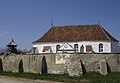
Unitarian Church in Valea Crișului

Ruins of the Veresbaratok Tornya Chapel
Reformed Church in Calnic

Bell tower and Unitarian church in Calnic


Web links
Individual evidence
- ↑ 2011 census in Romania ( MS Excel ; 1.3 MB).
- ^ Franz Raffelsperger : General Geographical-Statistical Lexicon of all Austrian States , Volume five, Vienna 1854.
- ↑ Arcanum Kézikönyvtár: Historical-administrative book of place names of Transylvania, Banat and Partium. Retrieved November 12, 2019 (Hungarian).
- ↑ Heinz Heltmann, Gustav Servatius (Ed.): Travel Guide Siebenbürgen . Kraft, Würzburg 1993, ISBN 3-8083-2019-2 , p. 517 .
- ^ Institute Of Archeology - Valea Crișului , accessed July 3, 2020 (Romanian).
- ↑ Lege pentru înființarea comunei Arcuș, prin reorganizareacomunei Valea Crișului, județul Covasna. (PDF; 140 kB) Accessed July 2, 2020 (Romanian).
- ↑ Censuses 1850–2002, last updated November 2, 2008 (PDF; 1 MB; Hungarian).
- ↑ a b c d e List of historical monuments of the Romanian Ministry of Culture , updated 2015 (PDF; 12.7 MB; Romanian).
- ↑ Information on Landhaus Kálnoky at castleintransylvania.ro, accessed on July 3, 2020 (English, Romanian, Hungarian)
- ↑ Information on Landhaus Kálnoky at monumenteuitate.org, accessed on July 3, 2020 (English, Romanian).
- ↑ Information on the Reformed Church in Calnic at biserici.org, accessed on June 3, 2020 (Romanian).
- ↑ Information on the Unitarian Church in Calnic at biserici.org, accessed on June 3, 2020 (Romanian).
Aita Mare | Arcuș | Barcani | Bățani | Belin | Bixad | Bodoc | Boroșneu Mare | Brateș | Brăduț | Brețcu | Catalina | Cernat | Chichiș | Comandău | Dalnic | Dobârlău | Estelnic | Ghelința | Ghidfalău | Hăghig | Ilieni | Lemnia | Malnaș | Mereni | Micfalau | Moacșa | Ojdula | Ozun | Poian | Reci | Sânzieni | Sita Buzăului | Turia | Valea Crișului | Valea Mare | Vâlcele | Vârghiș | Zagon | Zabala