
Voila (Brașov)
|
Voila wool village Vojlea |
|||||
|
|||||
| Basic data | |||||
|---|---|---|---|---|---|
| State : |
|
||||
| Historical region : | Transylvania | ||||
| Circle : | Brașov | ||||
| Coordinates : | 45 ° 49 ' N , 24 ° 50' E | ||||
| Time zone : | EET ( UTC +2) | ||||
| Height : | 420 m | ||||
| Area : | 86.42 km² | ||||
| Residents : | 2,660 (October 20, 2011) | ||||
| Population density : | 31 inhabitants per km² | ||||
| Postal code : | 507260 | ||||
| Telephone code : | (+40) 02 68 | ||||
| License plate : | BV | ||||
| Structure and administration (as of 2016) | |||||
| Community type : | local community | ||||
| Structure : | Voila, Cincşor , Dridif , Ludişor , Sâmbăta de Jos , Voivodeni | ||||
| Mayor : | Gheorghe-Marian Osalciuc ( PNL ) | ||||
| Postal address : | Str. Principală, no. 124 loc. Voila, jud. Brașov, RO-507260 |
||||


Voila ( German Wolldorf , Hungarian Vojlea ) is a municipality in the Brașov district , in the Transylvania region in Romania .
Geographical location

The municipality of Voila is located in the south of the Transylvanian Basin in the northern foothills of the Fagaras Mountains (Munții Făgăraș) . In the west of the Brașov district at the mouth of the Breaza brook in the Olt (Alt) , on the Avrig – Făgăraş railway line and on the European route 68 , Voila is eleven kilometers west of the city of Făgăraş (Fogarasch) ; the district capital Brașov (Kronstadt) is located about 75 kilometers southeast of Voila.
history
The place Voila was first mentioned in 1231. According to archaeological finds on the area of the incorporated village of Cincșor (Kleinschenk), however, settlement in the region dates back to the Early Bronze Age . In the Kingdom of Hungary , the municipality of Voila was in Fagaras County .
Until 2003, today's municipality of Sâmbăta de Sus (Ober-Mühlendorf) also belonged to the municipality of Voila.
population
The population of the municipality of Voila developed as follows:
| census | Ethnic composition | ||||
|---|---|---|---|---|---|
| year | population | Romanians | Hungary | German | other |
| 1850 | 5,717 | 4,921 | 22nd | 582 | 192 |
| 1910 | 6,860 | 5,788 | 348 | 629 | 97 |
| 1941 | 6,377 | 5,474 | 51 | 587 | 265 |
| 1977 | 6.168 | 5,588 | 33 | 381 | 166 |
| 1992 | 4,794 | 4,254 | 48 | 91 | 401 |
| 2002 | 4,618 | 4,186 | 30th | 40 | 362 |
| 2011 | 2,660 | 2,303 | 18th | 8th | 331 |
Since the official survey of 1850, the highest number of inhabitants - Romanians and Magyars at the same time - was registered in the territory of the municipality of Voila in 1910. The highest number of Romanian Germans (667) was determined in 1880 and that of Roma (401) in 1992. In addition, ten Slovaks were registered in 1910 (seven in 1910 and one in 1977) and four Ukrainians (two in 2002), and one Serb each in 1930 and 1966 .
Attractions
- In the incorporated village of Cincșor (Kleinschenk) : the evangelical fortified church of the Transylvanian Saxons , built in the 13th century, renovated in the 19th, is a listed building.
- In the incorporated village of Sâmbăta de Jos (Unter-Mühlendorf) the Brukenthal Castle , built between 1750 and 1760 by Josef von Brukenthal - the brother of Samuel von Brukenthal - has been owned by a forest company since 2002 and was in a desolate state in 2017. In 2020, only a few tiled stoves give an idea of the castle's former furnishings. The castle is a listed building.
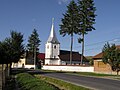
- In Sâmbăta de Jos the Romanian Orthodox Church Adormirea Maicii Domnului , built according to different statements in 1802 or 1806, are under monument protection.
- In the incorporated village of Voivodeni, the church Adormirea Maicii Domnului , built in the 13th century and renewed in the 20th century, one of the oldest stone churches in the Fagaras region and the church of Sf. Nicolae erected in 1767. Both churches are under monument protection.

Transylvanian-Saxon fortified church in Kleinschenk (Cincșor)

Bridge over the Alt at Kleinschenk
Orthodox Church in Kleinschenk (Cincșor), built in 1847


Web links
Individual evidence
- ↑ 2011 census in Romania ( MS Excel ; 1.3 MB)
- ^ Karl Gottlieb von Windisch: Geography of the Grand Duchy of Transylvania , Pressburg 1790
- ↑ Heinz Heltmann, Gustav Servatius (Ed.): Travel Guide Siebenbürgen. Kraft, Würzburg 1993, ISBN 3-8083-2019-2 .
- ^ Institute Of Archeology - Cincșor , accessed September 6, 2015 (Romanian).
- ↑ Census, last updated November 1, 2008 (Hungarian; PDF; 521 kB)
- ↑ a b c d e List of historical monuments of the Romanian Ministry of Culture, updated 2010 (PDF; 7.10 MB)
- ^ Brukenthal Castle, Sâmbăta de Jos. Retrieved December 1, 2019 (English, Hungarian, Romanian).
- ↑ The Brukenthal Castle is a ruin and a danger for tourists on September 23, 2017 at stirileprotv.ro, accessed on December 1, 2019 (Romanian)
- ↑ Ralf Sudrigian: Restoration of the Brukenthal Castle sought again. ADZ , June 11, 2020, accessed on June 18, 2020 .
- ↑ The Orthodox Church in Sâmbăta de Jos at biserici.org accessed on September 11, 2015 (Romanian)
- ↑ The Church of Adormirea Maicii Domnului at cimec.ro
- ↑ Gerhardt Binder (ed.): Small tavern in Transylvania: A home book . Publishing house of the Transylvanian-Saxon Foundation, Munich 1997, p. 14 .
Apața | Augustine | Beclean | Bod | Bran | Budila | Buneşti | Cața | Cincu | Comăna | Cristian | Crizbav | Drăguș | Dumbrăvița | Feldioara | Fundata | Hălchiu | Hărman | Hârseni | Hoghiz | Holbav | Homorod | Jibert | Lisa | Măieruș | Mândra | Moieciu | Ormeniș | Părău | Poiana Mărului | Prejmer | Racoș | Recea | Sâmbăta de Sus | Sânpetru | Șercaia | Șinca | Șinca Nouă | Șoarș | Tărlungeni | Teliu | Ticușu | Ucea | Ungra | Vama Buzăului | Viștea | Voila | Vulcan