Mândra (Brașov)
|
Mândra Kladendorf Mundra |
||||
|
||||
| Basic data | ||||
|---|---|---|---|---|
| State : |
|
|||
| Historical region : | Transylvania | |||
| Circle : | Brașov | |||
| Coordinates : | 45 ° 49 ' N , 25 ° 3' E | |||
| Time zone : | EET ( UTC +2) | |||
| Height : | 453 m | |||
| Area : | 87.97 km² | |||
| Residents : | 2,762 (October 20, 2011) | |||
| Population density : | 31 inhabitants per km² | |||
| Postal code : | 507125 | |||
| Telephone code : | (+40) 02 68 | |||
| License plate : | BV | |||
| Structure and administration (as of 2016) | ||||
| Community type : | local community | |||
| Structure : | Mândra, Ileni , Râuşor , Șona , Toderița | |||
| Mayor : | Taflan Ioan Șerban ( PSD ) | |||
| Postal address : | Str. Principală, no. 364 loc. Mândra, jud. Brașov, RO-507125 |
|||
| Website : | ||||
| Others | ||||
| City Festival : | 19./20. July, community festival | |||
Mândra , old spelling Mîndra [ ˈmɨndra ] ( German Kladendorf , Hungarian Mundra or Mondra ), is a municipality in the Brașov district in Transylvania , Romania .
Geographical location
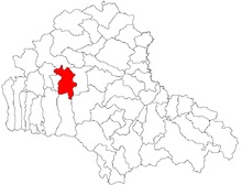
The municipality of Mândra is located southeast of the Transylvanian Basin in the northern foothills of the Fagaras Mountains ( Munții Făgăraș ). At the mouth of the stream of the same name in the Olt ( Alt ), on the Braşov – Făgăraş railway line and on the European route 68 , Mândra is seven kilometers east of the city of Făgăraş ( Fogarasch ). The district capital Brașov ( Kronstadt ) is located about 60 kilometers southeast of Mândra.
history
The place Mândra was first mentioned in 1400. Archaeological finds on the area of the municipality, about 8 kilometers south of the incorporated town of Șona ( beautiful ) on the mountain by the locals called pe Cetate (on the castle), indicate, according to Kurt Horedt and M. Roska, a settlement up to the La Tène time back. Numerous archaeological finds that point to the Hallstatt period were also made on the area of the incorporated village of Șona.
In the Kingdom of Hungary , today's municipality was partly in the Fogaras District (today Făgăraș ) and partly in the Sárkány District (today Șercaia ), both in the historical Fogaras County . Subsequently, the places of the municipality belonged to the administrative area of the Făgăraş County and from 1950 to the present day Braşov County.
Of the approximately 1280 properties in the community, none has a drinking water supply or sewage system. Around 600 of them are connected to the natural gas network.
In the parliamentary elections in 2012 , Mayor Șerban was a member of the social-liberal party USL , later he switched to the social democratic party PSD .
population
The 1850 census counted 4,197 people in the municipality of Mândra. In the predominantly Romanian population living community, has the highest number of inhabitants (4909) and at the same time the Romanians (4735) and the Romanian Germans registered (21) 1956th The highest population of the Roma (179) and that of the Magyars (46) was determined in 1930. Furthermore, in 1966 one of them confessed himself to be a Slovak . In 2011 there were 2,762 people living in the community. 2537 were Romanians, 62 were Roma, 25 were Magyars, one or two Romanian Germans and the rest of them gave no information about their ethnicity.
Attractions
- In the community center the Romanian Orthodox Church Înălțarea Domnului , built in 1779, is a listed building.
- In the incorporated village of Râuşor the churches of Sf. Cuvioasa Paraschiva (de Jos) built between 1782 and 1793 and the Sf. Cuvioasa Paraschiva (de Sus) built in 1698, both are listed.
- In the incorporated village of Șona, the church Adormirea Maicii Domnului, built around 1706, is a listed building.
Web links
- Mândra at ghidulprimariilor.ro
- Homepage of the village association "Our Şona" (Asociaţia Sătească "Şona Noastră"), Romanian, on Facebook
Individual evidence
- ↑ a b 2011 census in Romania ( MS Excel ; 1.3 MB)
- ^ Karl Gottlieb von Windisch: Geography of the Grand Duchy of Transylvania , Pressburg 1790
- ↑ Heinz Heltmann, Gustav Servatius (Ed.): Travel Guide Siebenbürgen. Kraft, Würzburg 1993, ISBN 3-8083-2019-2 .
- ↑ Institute Of Archeology - Șona at cimec.ro, accessed on May 5, 2016 (Romanian)
- ↑ Information on the municipality's website , accessed on May 4, 2016 (Romanian).
- ↑ Census, last updated November 1, 2008 (Hungarian; PDF; 521 kB)
- ↑ Information on the church in Mândra from biserici.org accessed on May 4, 2016 (Romanian)
- ↑ a b c List of historical monuments of the Romanian Ministry of Culture, updated 2010 (PDF; 7.10 MB)
- ↑ Information on the "lower" church in Râușor from biserici.org accessed on May 4, 2016 (Romanian)
- ↑ Information on the "upper" church in Râușor from biserici.org accessed on May 4, 2016 (Romanian)
- ↑ Information on the church in Șona from biserici.org accessed on May 4, 2016 (Romanian)


