Fundata (Brașov)
|
Fundata Fundatten Fundáta |
||||
|
||||
| Basic data | ||||
|---|---|---|---|---|
| State : |
|
|||
| Historical region : | Transylvania | |||
| Circle : | Brașov | |||
| Coordinates : | 45 ° 26 ' N , 25 ° 16' E | |||
| Time zone : | EET ( UTC +2) | |||
| Height : | 1300 m | |||
| Area : | 36.81 km² | |||
| Residents : | 852 (October 20, 2011) | |||
| Population density : | 23 inhabitants per km² | |||
| Postal code : | 507070 | |||
| Telephone code : | (+40) 02 68 | |||
| License plate : | BV | |||
| Structure and administration (as of 2016) | ||||
| Community type : | local community | |||
| Structure : | Fundata, Fundățica , Șirnea | |||
| Mayor : | Marian-Florin Pâtea ( PNL ) | |||
| Postal address : | Str. Principală, no. 56 loc. Fundata, jud. Brașov, RO-507070 |
|||
| Website : | ||||
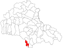
Fundata ( German Fundatten , Hungarian Fundáta ) is a municipality in the Brașov district in Transylvania , Romania .
Geographical location
Fundata is located in the extreme south-east of Transylvania, right on the border with Wallachia . The Pasul Bran ( Törzburger Pass ) , which is important for traffic, belongs to the municipality . To the west of the municipality is the Piatra Craiului , to the east the Bucegi Mountains and the Leaota Mountains .
history
The region above the Törzburg and in the region of the Törzburger Pass was probably settled around the end of the 17th century. Fundata was first mentioned in a document in 1732. It was a village of Romanian farmers and cattle herders.
After the place Fundata had belonged to the Kingdom of Hungary , the Principality of Transylvania and Austria-Hungary until the end of the First World War , it has been part of the State of Romania since then. Parts of today's municipal area were already part of the Principality of Wallachia and Romania before 1918.
On July 26, 2010, a military transport helicopter manned by six Israeli officers and a Romanian captain crashed in the municipality. In this context, the world public first learned of the military cooperation between Romania and Israel .
population
Since the first censuses in Transylvania, the community - which, in addition to Fundata, also includes the incorporated villages of Șirnea and Fundățica - has been reported as predominantly inhabited by Romanians . In 1850, 1629 inhabitants (all Romanians) were registered. Since the peak in 1941 (2284 inhabitants) the population has decreased significantly. In 2002, of the then 1008 inhabitants of the community, 1006 referred to themselves as Romanians and two as Hungarians .
In the village of Fundata itself, too, the number of inhabitants has declined significantly in recent decades. In 2002, 526 residents (525 Romanians, one Hungarian) were registered.
traffic
Fundata is located on the pass road between Brașov and Pitești , which corresponds to the European route 574 . There are bus connections to Brașov. The nearest train station is around 15 kilometers away in the city of Zărneşti on the Braşov – Zărneşti railway line .
Attractions
The church of Adormirea Maicii Domnului was built in the first half of the 19th century and is a listed building.
Fundata is the starting point for hikes in the Piatra Craiului and Bucegi mountains.
Web links
Individual evidence
- ↑ 2011 census in Romania ( MS Excel ; 1.3 MB)
- ^ Bogdan-Florin Popovici: Problema demografică in regiunea Branului de Sus. In: Studii și Materiale de Istorie Medie (SMIM). Vol. 25, 2007, ISSN 1222-4766 , pp. 171-182.
- ↑ http://www.roghid.ro/Bran.php/ ( Memento from July 5, 2007 in the Internet Archive )
- ↑ punkto.ro of July 28, 2010, accessed on August 2, 2010 .
- ↑ Census, last updated November 1, 2008 (Hungarian; PDF; 525 kB)


