
Snøhetta: Difference between revisions
m WP:CHECKWIKI errors fixed + general fixes using AWB (8961) |
update infobox, location, reference, misc, Reference edited with ProveIt Tags: ProveIt edit nowiki added |
||
| (14 intermediate revisions by 13 users not shown) | |||
| Line 1: | Line 1: | ||
{{short description|Mountain in Dovre, Norway}} |
|||
{{For|the company Snøhetta|Snøhetta (company)}} |
{{For|the company Snøhetta|Snøhetta (company)}} |
||
{{Infobox mountain |
{{Infobox mountain |
||
| |
|name = Snøhetta |
||
|other_name = |
|||
| |
|photo = Snohetta.jpg |
||
| ⚫ | |||
|photo_size = |
|||
| ⚫ | |||
| ⚫ | |||
| elevation_ref = |
|||
|map = Innlandet#Norway |
|||
| ⚫ | |||
|map_alt = Map of the location |
|||
| prominence_ref = <ref>[http://www.ii.uib.no/~petter/mountains/scandinavia_finest.html Top 100 Mountains in Scandinavia ranked by primary factor<!-- Bot generated title -->]</ref> |
|||
|map_caption = Location of the mountain |
|||
| ⚫ | |||
|label = |
|||
| ⚫ | |||
|label_position = bottom |
|||
| ⚫ | |||
|coordinates = {{coord|62.31984|9.26769|region:NO_type:mountain|display=inline,title|format=dms}}<ref>{{Cite web |title=Snøhetta, Dovre |url=https://www.yr.no/nb/v%C3%A6rvarsel/daglig-tabell/1-185500/Norge/Innlandet/Dovre/Sn%C3%B8hetta |publisher=[[yr.no]] |language=Norwegian |accessdate=2022-04-15}}</ref> |
|||
| coordinates = {{coord|62|19|12|N|9|16|6|E|type:mountain_region:NO|display=inline,title}} |
|||
| ⚫ | |||
| ⚫ | |||
| ⚫ | |||
| ⚫ | |||
| ⚫ | |||
|isolation_km = 82.2 |
|||
|elevation_ref = <ref name="pv">{{Cite web |title=Snøhetta |url=https://peakvisor.com/peak/snohetta.html |website=PeakVisor.com |accessdate=2022-04-15}}</ref><ref name="PB">{{Cite web |last=Bjørstad |first=Petter |year=2009 |title=100 Finest in Scandinavia |url=http://www.ii.uib.no/~petter/mountains/scandinavia_finest.html |accessdate=2022-04-16}}</ref> |
|||
|prominence_ref = <ref name="pv" /><ref name="PB" /> |
|||
|isolation_ref = <ref name="pv" /> |
|||
| ⚫ | |||
|parent_peak = |
|||
| ⚫ | |||
|type = |
|||
|age = |
|||
| ⚫ | |||
|easiest_route = |
|||
| ⚫ | |||
}} |
}} |
||
'''Snøhetta''' is the highest mountain in the [[Dovrefjell]] range, |
'''Snøhetta''' is the highest mountain in the [[Dovrefjell]] mountain range in [[Norway]]. At {{convert|2286|m}}, it is the highest mountain in [[Norway]] outside the [[Jotunheimen]] range, making it the [[List of mountains in Norway by height|24th highest peak in Norway]], based on a {{convert|30|m|adj=on}} [[topographic prominence]] cutoff. At {{convert|1675|m}}, its [[List of mountains in Norway by prominence|topographic prominence]] is the third highest in Norway.<ref name="snl">{{Cite encyclopedia |title=Snøhetta |encyclopedia=[[Store norske leksikon]] |publisher=[[Kunnskapsforlaget]] |url=https://snl.no/Sn%C3%B8hetta |date=2021-02-15 |editor-last=Thorsnæs |editor-first=Geir |language=Norwegian |accessdate=2022-04-16}}</ref> |
||
The mountain is located in the Dovrefjell mountains in northern [[Innlandet]] county in [[Dovre Municipality]]. The mountain lies inside [[Dovrefjell-Sunndalsfjella National Park]] and it is the highest peak in the park. It is surrounded by several other mountains including [[Brunkollen]] to the east; [[Einøvlingseggen]] to the south; [[Skredahøin]] [[Bruri]], [[Nordre Svånåtinden]], and [[Storstyggesvånåtinden]] to the southwest; and [[Store Langvasstinden]], [[Larstinden]], and [[Drugshøi]] to the west. |
|||
The mountain is inside [[Dovrefjell-Sunndalsfjella National Park]]. |
|||
The mountain has several peaks:<ref> |
The mountain has several peaks:<ref>{{Cite web |last=Poppe |first=Erik |title=Fjell i Norge over 2200moh |url=http://www.poppe-oldervoll.net/klatre/fjell2200.html |language=Norwegian |accessdate=2022-04-16}}</ref> |
||
* '''Stortoppen''' |
* '''Stortoppen''' is the highest summit at {{convert|2286|m}}. |
||
* '''Midttoppen''' |
* '''Midttoppen''' is the next highest summit reaching {{convert|2278|m}} with a [[topographic prominence]] of {{convert|40|m}}. |
||
* '''Hettpiggen''' |
* '''Hettpiggen''' is the third highest peak on the mountain reaching {{convert|2261|m}} with a prominence of {{convert|50|m}}. |
||
* '''Vesttoppen''' |
* '''Vesttoppen''' is the fourth highest peak at an elevation of {{convert|2253|m}} and a prominence of {{convert|70|m}}. |
||
Vesttoppen and Stortoppen are easily available by hiking or skiing, and from Stortoppen Midttoppen is easily accessible. Traversing Midttoppen, via Hettpiggen and to Vesttoppen requires [[climbing]] with a rope. |
Vesttoppen and Stortoppen are easily available by hiking or skiing, and traveling from Stortoppen, Midttoppen is easily accessible. Traversing Midttoppen, via Hettpiggen and to Vesttoppen requires [[climbing]] with a rope. |
||
On Stortoppen there is a radio link station, originally installed by the [[Norwegian Army]], and now serving primarily civilian purposes. The station and its emergency diesel generator, as well as a nearby [[helipad]], detract somewhat from the aesthetics of the summit. For this reason, many recommend Vesttoppen as a better destination. |
On Stortoppen there is a radio link station, originally installed by the [[Norwegian Army]], and now serving primarily civilian purposes. The station and its emergency diesel generator, as well as a nearby [[helipad]], detract somewhat from the aesthetics of the summit. For this reason, many recommend Vesttoppen as a better destination. |
||
| Line 35: | Line 49: | ||
==History== |
==History== |
||
Snøhetta was visited for the first time in 1798 as part of a scientific trip to the area. At that time it was assumed that was the highest summit in Norway, because the [[Jotunheimen]] area with its higher peaks was rather inaccessible and unresearched, while Snøhetta is visible from the traditional travel route Oslo-Trondheim across Dovrefjell. |
Snøhetta was visited for the first time in 1798 as part of a scientific trip to the area. At that time it was assumed that was the highest summit in Norway, because the [[Jotunheimen]] area with its higher peaks was rather inaccessible and unresearched, while Snøhetta is visible from the traditional travel route Oslo-Trondheim across the Dovrefjell mountains. The expression "until the Dovre mountains fall" ({{lang-no|"til Dovre faller"}}) was used in the oath sworn during the [[Norwegian Constituent Assembly]] in 1814, when Norway formed an [[Kingdom of Norway (1814)|independent nation]] after being in a [[Denmark-Norway|union with Denmark]] for hundreds of years.<ref name="snl" /> |
||
== |
==Etymology== |
||
The name is a compound of ''snø'' |
The name is a compound of the Norwegian word ''snø'' which means "[[snow]]" and the finite form of ''hette'' which means "[[hood (headgear)|hood]]", thus the name is translated as "the mountain with a hood of snow".<ref name="snl" /> |
||
==Media gallery== |
|||
| ⚫ | |||
<gallery mode="packed" heights="180px"> |
|||
1009. Dovrefjeld, Snehætten - no-nb digifoto 20160104 00077 bldsa AL1009.jpg|View from a distance |
|||
Peder Balke - Mt. Snøhetta, Dovre Mountains - TKM-1121-1972 - Trondheim kunstmuseum (cropped).jpg|Painting of the mountain by Peder Balke |
|||
Snøhetta (east elevation from E6).jpg|View of the east side from the E6 highway |
|||
Hjerkinn mot Snøhetta - no-nb digifoto 20151105 00042 NB MIT FNR 06490.jpg|Snøhetta seen from [[Hjerkinn]] |
|||
StortoppenFromHettpiggenSnøhetta.jpg|Stortoppen seen from Hettpiggen in summer |
|||
</gallery> |
|||
==References== |
==References== |
||
| Line 48: | Line 69: | ||
* [http://www.pvv.ntnu.no/~berland/fjell/?fjell=snohetta Annotated photo-panoramas] |
* [http://www.pvv.ntnu.no/~berland/fjell/?fjell=snohetta Annotated photo-panoramas] |
||
* [http://www.scandinavianmountains.com/areas/18-dovrefjell/mountains/18.01-snøhetta/index.htm Snøhetta] |
* [http://www.scandinavianmountains.com/areas/18-dovrefjell/mountains/18.01-snøhetta/index.htm Snøhetta] |
||
| ⚫ | |||
==Guidebook== |
==Guidebook== |
||
* |
*{{Cite book |last=Dyer |first=Anthony |title=Walks and Scrambles in Norway |last2=Baddeley |first2=John |last3=Robertson |first3=Ian H. |publisher=Rockbuy Limited |year=2006 |isbn=9781904466253}} |
||
{{Ultras of Europe}} |
{{Ultras of Europe}} |
||
{{DEFAULTSORT:Snohetta}} |
{{DEFAULTSORT:Snohetta}} |
||
[[Category:Mountains of |
[[Category:Mountains of Innlandet]] |
||
[[Category:Dovre]] |
|||
Latest revision as of 15:54, 16 April 2022
| Snøhetta | |
|---|---|
 Snøhetta. From the left, the peaks are Vesttoppen, Hettpiggen, Midttoppen and then Stortoppen (highest) to the right. | |
| Highest point | |
| Elevation | 2,286 m (7,500 ft)[1][2] |
| Prominence | 1,675 m (5,495 ft)[1][2] |
| Isolation | 82.2 km (51.1 mi)[1] |
| Listing | Ultra #3 in Norway by prominence #24 in Norway by height |
| Coordinates | 62°19′11″N 9°16′04″E / 62.31984°N 9.26769°E[3] |
| Geography | |
 Snøhetta Location of the mountain  Snøhetta Snøhetta (Norway) | |
| Location | Innlandet, Norway |
| Parent range | Dovrefjell |
| Topo map | 1519 IV Snøhetta |
| Climbing | |
| First ascent | 1798 by Jens Esmark |
Snøhetta is the highest mountain in the Dovrefjell mountain range in Norway. At 2,286 metres (7,500 ft), it is the highest mountain in Norway outside the Jotunheimen range, making it the 24th highest peak in Norway, based on a 30-metre (98 ft) topographic prominence cutoff. At 1,675 metres (5,495 ft), its topographic prominence is the third highest in Norway.[4]
The mountain is located in the Dovrefjell mountains in northern Innlandet county in Dovre Municipality. The mountain lies inside Dovrefjell-Sunndalsfjella National Park and it is the highest peak in the park. It is surrounded by several other mountains including Brunkollen to the east; Einøvlingseggen to the south; Skredahøin Bruri, Nordre Svånåtinden, and Storstyggesvånåtinden to the southwest; and Store Langvasstinden, Larstinden, and Drugshøi to the west.
The mountain has several peaks:[5]
- Stortoppen is the highest summit at 2,286 metres (7,500 ft).
- Midttoppen is the next highest summit reaching 2,278 metres (7,474 ft) with a topographic prominence of 40 metres (130 ft).
- Hettpiggen is the third highest peak on the mountain reaching 2,261 metres (7,418 ft) with a prominence of 50 metres (160 ft).
- Vesttoppen is the fourth highest peak at an elevation of 2,253 metres (7,392 ft) and a prominence of 70 metres (230 ft).
Vesttoppen and Stortoppen are easily available by hiking or skiing, and traveling from Stortoppen, Midttoppen is easily accessible. Traversing Midttoppen, via Hettpiggen and to Vesttoppen requires climbing with a rope.
On Stortoppen there is a radio link station, originally installed by the Norwegian Army, and now serving primarily civilian purposes. The station and its emergency diesel generator, as well as a nearby helipad, detract somewhat from the aesthetics of the summit. For this reason, many recommend Vesttoppen as a better destination.
A small monument for the Norwegian philosopher, humourist, author and mountaineer Peter Wessel Zapffe is located near the summit of Vesttoppen.
Under good conditions in both summer and winter, the ascent is relatively easy. Common starting points are the DNT-cabins Reinheim, Snøheim, or Åmotdalshytta.
History[edit]
Snøhetta was visited for the first time in 1798 as part of a scientific trip to the area. At that time it was assumed that was the highest summit in Norway, because the Jotunheimen area with its higher peaks was rather inaccessible and unresearched, while Snøhetta is visible from the traditional travel route Oslo-Trondheim across the Dovrefjell mountains. The expression "until the Dovre mountains fall" (Norwegian: "til Dovre faller") was used in the oath sworn during the Norwegian Constituent Assembly in 1814, when Norway formed an independent nation after being in a union with Denmark for hundreds of years.[4]
Etymology[edit]
The name is a compound of the Norwegian word snø which means "snow" and the finite form of hette which means "hood", thus the name is translated as "the mountain with a hood of snow".[4]
Media gallery[edit]
-
 View from a distance
 -
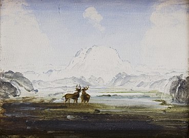 Painting of the mountain by Peder Balke
 -
 View of the east side from the E6 highway
 -
 Snøhetta seen from Hjerkinn
 -
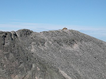 Stortoppen seen from Hettpiggen in summer

.jpg)
.jpg)


References[edit]
- ^ a b c "Snøhetta". PeakVisor.com. Retrieved 2022-04-15.
- ^ a b Bjørstad, Petter (2009). "100 Finest in Scandinavia". Retrieved 2022-04-16.
- ^ "Snøhetta, Dovre" (in Norwegian). yr.no. Retrieved 2022-04-15.
- ^ a b c Thorsnæs, Geir, ed. (2021-02-15). "Snøhetta". Store norske leksikon (in Norwegian). Kunnskapsforlaget. Retrieved 2022-04-16.
- ^ Poppe, Erik. "Fjell i Norge over 2200moh" (in Norwegian). Retrieved 2022-04-16.
External links[edit]
Guidebook[edit]
- Dyer, Anthony; Baddeley, John; Robertson, Ian H. (2006). Walks and Scrambles in Norway. Rockbuy Limited. ISBN 9781904466253.