São João da Boa Vista: Difference between revisions
+infobox |
+refs |
||
| Line 25: | Line 25: | ||
|subdivision_name2 = [[Image:Bandeira_do_estado_de_São_Paulo.svg|border|22px]] [[São Paulo (state)|São Paulo]] |
|subdivision_name2 = [[Image:Bandeira_do_estado_de_São_Paulo.svg|border|22px]] [[São Paulo (state)|São Paulo]] |
||
|leader_title = Mayor |
|leader_title = Mayor |
||
|leader_name = Vanderlei Borges de Carvalho |
|leader_name = Vanderlei Borges de Carvalho<ref name="u"/> |
||
|leader_title1 = <!-- for places with, say, both a mayor and a city manager --> |
|leader_title1 = <!-- for places with, say, both a mayor and a city manager --> |
||
|leader_name1 = |
|leader_name1 = |
||
| Line 57: | Line 57: | ||
|elevation_m = 767 |
|elevation_m = 767 |
||
}} |
}} |
||
'''São João da Boa Vista''' is a municipality in the state of [[São Paulo (state)|São Paulo]] in [[Brazil]]. The population in |
'''São João da Boa Vista''' is a municipality in the state of [[São Paulo (state)|São Paulo]] in [[Brazil]]. The population in 2010 was 83,639 and the area is {{convert|516,399|km2|mi2}}. The elevation is {{Convert|767|m|ft}}.<ref name="i"/> |
||
==The foundation history== |
==The foundation history== |
||
| Line 89: | Line 89: | ||
|0,50% |
|0,50% |
||
|} |
|} |
||
==References== |
|||
{{reflist|2|refs= |
|||
<ref name="i">{{cite web | url = http://cod.ibge.gov.br/232WE | title = São João da Boa Vista | year = 2015 | publisher = Instituto Brasileiro de Geografia e Estatstica | location = Braslia, Brazil | accessdate = 2015-07-06 | language = Portuguese}}</ref> |
|||
<ref name="u">{{cite web | url = http://eleicoes.uol.com.br/2012/candidatos/2012/prefeito/sp/16041957-vanderlei-da-prefeitura.htm | title = VANDERLEI BORGES DE CARVALHO | year = 2015 | publisher = UOL | accessdate = 2015-07-06 | language = Portuguese}}</ref> |
|||
}} |
|||
{{São Paulo state|Campinas}} |
{{São Paulo state|Campinas}} |
||
Revision as of 01:19, 7 July 2015
21°58′09″S 46°47′53″W / 21.96917°S 46.79806°W
São João da Boa Vista | |
|---|---|
Municipality | |
| Município de São João da Boa Vista | |
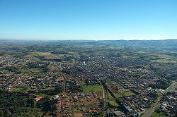
 Aerial view of São João da Boa Vista | |
 Location of São João da Boa Vista in São Paulo (state) | |
| Country | Brazil |
| Region | Southeast Region |
| State | |
| Founded | June 24, 1821 |
| Government | |
| • Mayor | Vanderlei Borges de Carvalho[1] |
| Area | |
| • Total | 516.146 km2 (199.285 sq mi) |
| Elevation | 767 m (2,516 ft) |
São João da Boa Vista is a municipality in the state of São Paulo in Brazil. The population in 2010 was 83,639 and the area is 516,399 square kilometres (199,383 sq mi). The elevation is 767 metres (2,516 ft).[2]
The foundation history
The city was founded on June 24, 1821. In the beginning of last century, a group of miners decided to rest at the edge of Jaguari Mirim River, already in São Paulo state, and got astonished by the exuberant view of the nature. They got so delighted that on that Saint John's day, the miners started up the construction of the town and, to celebrate the Saint of that day as well as because of the amazing twilights at the sunset, the city was named São João da Boa Vista. Only 14 years later, the town was claimed a district. On March 24, 1859 it became a city, and on February 7, 1885 it was considered a judicial district, offering its citizens all the basic infrastructure.
Demographics
São João da Boa Vista possesses, according to IBGE 2010, 83,661 inhabitants.
| Color/Race | Percentage |
|---|---|
| White | 85,36% |
| African | 4,47% |
| Multiracial | 9,54% |
| Asian | 0,09% |
| Indigenous Peoples | 0,03% |
| Without Declaration | 0,50% |
References
- ^ "VANDERLEI BORGES DE CARVALHO" (in Portuguese). UOL. 2015. Retrieved 2015-07-06.
- ^ "São João da Boa Vista" (in Portuguese). Braslia, Brazil: Instituto Brasileiro de Geografia e Estatstica. 2015. Retrieved 2015-07-06.


