
Attersee am Attersee
|
Attersee am Attersee
|
||
|---|---|---|
| coat of arms | Austria map | |
 |
|
|
| Basic data | ||
| Country: | Austria | |
| State : | Upper Austria | |
| Political District : | Vöcklabruck | |
| License plate : | VB | |
| Surface: | 14.62 km² | |
| Coordinates : | 47 ° 55 ' N , 13 ° 32' E | |
| Height : | 496 m above sea level A. | |
| Residents : | 1,604 (January 1, 2020) | |
| Postal code : | 4864 | |
| Area code : | 07666 | |
| Community code : | 4 17 02 | |
| NUTS region | AT315 | |
| Address of the municipal administration: |
Nußdorferstraße 15 4864 Attersee am Attersee |
|
| Website: | ||
| politics | ||
| Mayor : | Walter Kastinger ( SPÖ ) | |
|
Municipal Council : (2015) (19 members) |
||
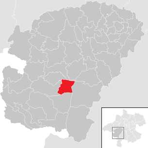
| Location of Attersee am Attersee in the Vöcklabruck district | ||
  |
||
 Attersee parish on the Attersee, seen from the Kronbergerkapelle |
||
| Source: Municipal data from Statistics Austria | ||

Attersee am Attersee is a municipality in Upper Austria in the Vöcklabruck district in the Hausruckviertel with 1604 inhabitants (as of January 1, 2020). The community is located in the judicial district of Vöcklabruck .
geography
The municipality of Attersee is located at 496 m above sea level on the Attersee . The extension is from north to south 5.3 km, from west to east 4.6 km. The total area is 14.7 km², 21.1% of the area is forested, 36.7% of the area is used for agriculture.
Community structure
The municipality includes the following nine localities (population in brackets as of January 1, 2020):
- Abtsdorf (353)
- Altenberg (83)
- Attersee (397)
- Aufham (100)
- Breitenröth (67)
- Muhlbach (170)
- Neuhofen (117)
- Oberbach (59)
- Palmsdorf (258)
The community consists of the cadastral communities Abtsdorf and Attersee.
coat of arms
Blazon : “Divided by a golden bar, pinned at the top and curved at the bottom; at the top a golden, five-pointed crown in red; below a silver fish in blue. ”The community colors are white-blue.
The coat of arms, awarded in 1972, reminds with crown and battlements that a royal court already stood on the Atterseer Kirchberg in the 9th century. The fish on a blue background stands for the location on the Attersee and fishing as an important branch of the economy in the past.
history
In the Neolithic Age , there were numerous pile dwellings that were built into the lake. Pile building finds on the Seeboden in front of the localities Aufham and Altenberg attest to a dense settlement in the Neolithic Age. The Buchberg summit also seems to have been inhabited in prehistoric times.
No archaeologically significant finds are known from Roman times. However, the traces of the Middle Ages, which have been scientifically researched through excavations on the Kirchberg since the 1970s, are impressive.
The secular center was in the early Middle Ages in what is now Attersee. On the Atterseer Kirchberg there was a royal court (lat. Curtis), which was first mentioned in a document in 885 as "Atarnhova" (Atterhofen) and was visited several times by Franconian kings in the course of the 9th century. For example, King Arnulf was present in Attersee in 888.
In 1007 the territory of the Atterse Castle was donated by King Heinrich II to the newly founded Diocese of Bamberg with Bishop Eberhard I. Attersee thus belonged to the diocese of Bamberg. This property in Attergau included "villages, hamlets, churches, servants and maidservants, vacant building sites and buildings, cultivated and wild land, forests and forests, waters with fishing rights and mills". All of this is recorded in the deed of donation, which is written in Latin. At that time the Attergau comprised the area of today's Vöcklabruck district. The Mondseerland was excluded.
The Attersee Castle was expanded with fortifications in the period that followed and was the dominant center of the Attergau in the High Middle Ages. The building only fell into disrepair in the late Middle Ages, when a new castle (documented around 1440 as "Neu Attersee", later called "Kogl") was built on the Koglberg near St. Georgen .

In 1379 the Habsburgs acquired the Bamberg property in the Attergau from the Schaunbergers . In the late Middle Ages, however, the center of power was relocated to the higher Koglberg near St. Georgen for technical reasons. The castle complex in Attersee was therefore left to decay. The remains of the castle are under the church square and under the school garden. Attersee was a much-visited place of pilgrimage in the Baroque period.
Attersee has been a parish since 1276. The Gothic parish and pilgrimage church of Maria Himmelfahrt stands high above the town on the historic Kirchenberg, which used to be a castle hill. The church emerged from the Gothic castle chapel. Between 1712 and 1728, the patron saint Anton Graf Khevenhüller had the church rebuilt by the baroque master builder Jakob Pawanger . At that time, the tower was also given the baroque onion helmet. The high altar shows the miraculous image "Mary in the sun". It has been a pilgrimage church since 1652, when the cult object was placed in it.
politics
Mayor is Walter Kastinger from the SPÖ.
Population development
According to the 1991 census, the municipality had 1481 inhabitants, 1496 inhabitants in 2001 and 1590 inhabitants in 2011. In 2019, 1,583 inhabitants were expelled. This corresponds to a growth of 6.89 percent in 28 years.
Culture and sights

- Catholic parish and pilgrimage church Attersee : The first church was built by Bishop Eberhard I in 1010. In the baroque period, Attersee experienced a new boom as a place of pilgrimage. After the transfer of the miraculous image “Maria in der Sonne” from St. Georgen to Attersee in 1652, the former Gothic castle church was expanded into a baroque pilgrimage church. At the beginning of the 18th century, the building was enlarged and the interior was given a Baroque style in the form that has been preserved to this day. The center of the high altar is the image of Mary in a rococo silver frame. The figure “Maria with the child” above could come from an earlier Gothic altar. It was only placed on the high altar again during the church renovation in 1910. A special work of art is the Gothic relief of the Adoration of the Wise Men from the Orient (here as a replica). The statuettes of the three doctors of the church, carved by the Mondsee sculptor Meinrad Guggenbichler , which are now under a glass lintel on the right side altar, are also of great art historical value .
- Evangelical Church Attersee : A late Gothic sacred building with neo-Gothic furnishings. Until 1813 the church was the Roman Catholic. Parish Church of Attersee. Between 1810 and 1816 the western part of the Attersee belonged to the Kingdom of Bavaria . In 1813 the Protestant parish Attersee was established by the Bavarian king. The reason for this was that the tolerance community of Rutzenmoos , to which the evangelical families of the Attergau had belonged since Joseph II granted religious freedom, was in Austria at the time.
- Parish church Abtsdorf : The parish Abtsdorf, which is already mentioned in a document in 1142, belonged to the Benedictine monastery Mondsee until the abbey was dissolved in 1791. The former affiliation to Mondsee is also expressed in the place name Abtsdorf. The three altars and the pulpit were created by the sculptor Meinrad Guggenbichler from Mondsee between 1699 and 1703.
- Perspektiven Attersee art festival: Since 2011, the annual series of events and exhibitions has made it its task to fill the public space of the Attersee holiday resort with art over the summer months. The empty shops in the town center due to changed shopping behavior and the extinction of rural retail trade are temporarily used as a creative space and meeting zone. In the first few years of the project, photo installations mainly focused on the problems of the previously flourishing shops and streets, meanwhile the programmatic spectrum of the festival has expanded to include graphic design, photography, fashion design and dance.
Web links
- official page
- More information about the community of Attersee am Attersee on the geo-information system of the federal state of Upper Austria .
- Map in the Digital Upper Austrian Room Information System ( DORIS )
- 41702 - Attersee am Attersee. Community data, Statistics Austria .
Individual evidence
- ↑ According to the municipal council resolution of August 17 and December 14, 2007, approved by resolution of the state government of February 25, 2008, announced in LGBl 40/2008 on March 31, 2008.
- ↑ Statistics Austria: Population on January 1st, 2020 by locality (area status on January 1st, 2020) , ( CSV )
- ↑ Herbert Erich Baumert: The coats of arms of the cities, markets and communities of Upper Austria (3rd supplement) , in Oberösterreichische Heimatblätter, Heft 1/2, 1973, p. 8 ( online (PDF) in the forum OoeGeschichte.at)
- ↑ Perspektiven Attersee - Annual Art Festival in the heart of the village Attersee am Attersee. Retrieved July 27, 2018 (American English).
- ↑ Change of perspective or It depends on the perspective - Kirtag . In: Kirtag . July 3, 2014 ( kirtag.org [accessed July 27, 2018]).

Ampflwang in the Hausruckwald | Attersee am Attersee | Attnang-Puchheim | Atzbach | Aurach am Hongar | Berg im Attergau | Desselbrunn | Fornach | Frankenburg | Frankenmarkt | Gampern | Innerschwand am Mondsee | Lenzing | Manning | Mondsee | Neukirchen an der Vöckla | Niederthalheim | Nussdorf am Attersee | Oberhofen am Irrsee | Oberndorf near Schwanenstadt | Oberwang | Ottnang am Hausruck | Pfaffing | Pilsbach | Pitzenberg | Pondorf | Puchkirchen | Pühret | Redleiten | Redlham | Regau | Riistorf | Rutzenham | Schlatt | Schörfling am Attersee | Schwanenstadt | Seewalchen am Attersee | St. Georgen im Attergau | St. Lorenz | Steinbach am Attersee | Straß im Attergau | Dig deep | Timelkam | Inaccurate | Unterach am Attersee | Vöcklabruck | Vöcklamarkt | Weißenkirchen im Attergau | Weyregg am Attersee | Wolfsegg am Hausruck | Zell am Moos | Zell am Pettenfirst