
Motorway (Croatia)

.svg)
The highways ( Croatian : Autoceste , singular Autocesta ) are a type of road in Croatia and form part of the national trunk road network. They serve national and international traffic.
There are currently motorways with a length of around 1,220 kilometers, and around 140 kilometers are being built. The planned motorway network is around 1,800 kilometers. The most important and longest motorway connection is the A1 . Other important connections are the A3 , A2 , A4 and A6 .
All motorways are charged (Croatian: Cestarina ) and there is a speed limit of 130 km / h.
history


Motorway construction in the Croatian republic of the SFR Yugoslavia began in 1970. Until the end of the 1960s, no motorways were built. After the so-called Croatian Spring , the first 50 kilometers in total near Rijeka and from Zagreb to Karlovac were cleared in 1971/72 . However, with the exception of a short section, no more motorway kilometers were completed until 1980 and the few new buildings in the 1980s were limited almost exclusively to the route from Zagreb to Slavonski Brod (as part of the Autoput Bratstvo i jedinstvo , today the A3 motorway until the declaration of independence in 1991 ). In addition, the expansion of the Zagreb-Karlovac motorway to the second largest city of Split (today the A1 motorway ) and the most important port city of Rijeka (today the A6 motorway ) has always been prevented by the ruling communist party. Because of the Croatian War, no new buildings were built up to 1996 on the 284.4 km of motorways and another 23.8 kilometers of semi-autobahns.
At the beginning of the 2000s, motorway construction accelerated. The main reasons for this were that the Croatian government granted concessions for certain motorway projects.
The most important motorway project was the 467 km long A1 motorway from Zagreb via Split to Vrgorac . It was completely expanded on June 26, 2005, that is, consistently two-lane in both directions (two-tube tunnels are present on the entire route). The A1 connects the continental part of Croatia with the Mediterranean Dalmatia. The main building , the Sveti-Rok - road tunnel (5.687 m) through the Velebit massif represents that connects virtually two climate zones with each other (the central mountain climate Croatia with the Mediterranean climate Dalmatian ). The most modern and at the same time longest tunnel in Croatia is also on the A1 route. This is the tunnel through the Mala Kapela mountain range (5,780 m). In 2013 it was continued to the important southern Dalmatian port city of Ploče .
In the spring of 2004, the last remaining section of the A6 motorway connection between Rijeka and Zagreb was completed. Since October 2008, the autobahn has been continuously passable with two lanes. In June 2005, the A9 motorway at Umag in the south to Rovinj and Pula and the A7 motorway from the Rupa border crossing to Rijeka existed from the Slovenian border . In June 2006 the last section of the A3 motorway from Županja (East Slavonia ) to Serbia was opened . In May 2007 the A2 Zagreb− Krapina motorway was completed ( Macelj border crossing , south of Maribor ).
The eastern and western "wings" of the so-called " Istrian Ypsilon ", the A8 and the A9 (expressway connection in Istria ) have been open to traffic since the beginning of June 2005. Currently, some of these are only run with one lane as an expressway . The work for the full expansion will be carried out in stages.
The expansion of the European north-south corridor 5c between the Hungarian border at Beli Manastir , Osijek and the Bosnian border in the direction of Sarajevo is being implemented as the A5 motorway . On November 9, 2007, the section of the A5 from Sredanci to Đakovo was officially opened for regular traffic. In 2009 the part from Đakovo to Osijek was completed.
From 1996 to 1999, 126.8 kilometers of motorway were initially released, so that the motorway network increased to 381.9 km as a full and 53.1 km as a half-extension. In the first half of the 2000s, sections with a length of 444.5 km, 14.4 km of which were semi-freeways, were released. The motorway network was 879.5 km at the end of 2005, 67.5 km of which were open as semi-highways. In the period from 2006 to 2010, 252.4 km were completed. At the end of 2010, the completed motorway network was 1,106.3 km. The 1000 km mark was exceeded with the opening of the 40.3 km long section of the A1 motorway between Šestanovac and Ravča on December 22, 2008. From 2011 a further 104.7 kilometers of motorway were completed and opened. The current motorway network is therefore 1211 km.
At the end of 2012, the Croatian government announced that it wanted to privatize the entire state-run network with the two public operators HAC and ARZ.

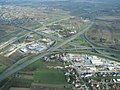
The Orehovica motorway junction between the A6 and A7 near Rijeka .

The Novi Marof exit along the A4.
The Lučko motorway junction near Zagreb between the A3 and A1.
The Lučko toll booth on the A1 near the motorway junction of the same name.


_at_%C4%90urmanec.jpg)


Open to traffic 1972 - 1991
- Section of the A6 : Orehovica - Kikovica (10.5 km; opened on September 9, 1972)
- Section of the A1 : Zagreb - Karlovac (39.3 km; opened on December 29, 1972)
- Section of the A3 : Jankomir (Zagreb) - Lučko (5.9 km; opened 1979)
- Section of the A2 as a semi- motorway : Jankomir - Zaprešić (8.2 km; opened 1980)
- Section of the A3: Ivanja Reka - Lipovljani (76.5 km; opened 1980)
- Section of the A3: Lučko - Ivanja Reka (22.1 km; opened 1981)
- Section of the A6 as a semi-freeway: Kikovica - Oštrovica (7.3 km; opened 1982)
- Section of the A3: Lipovljani - Okučani (35.8 km; opened 1985)
- Section of the A3: Okučani - Prvča (7.5 km; opened in 1986)
- Section of the A7 as a semi- freeway : Diračje - Orehovica (8.3 km; opened in July 1988)
- Section of the A3: Prvča - Brodski Stupnik (40.6 km; opened in 1988)
- Section of the A3: Brodski Stupnik - Slavonski Brod -zapad (8.8 km; opened in 1989)
- Section of the A7: Matulji - Diračje (4 km; opened in 1990)
- Section of the A2: Zaprešić - Gubaševo (17.5 km; opened 1991)
- Section of the A3: Slavonski Brod-zapad - Slavonski Brod-istok (8.8 km; opened 1991)
- Section of the A7: Jušići - Matulji (7.1 km; opened 1991)
Approved for traffic 1996 - 2005
- Section of the A2: Gubaševo - Krapina (15.7 km; opened in 1996)
- Section of the A3: Slavonski Brod-istok - Oprisavci (10.9 km; opened in 1996)
- Section of the A6 as a semi-freeway: Oštrovica - Delnice (21.4 km; opened in 1996)
- Section of the A4 : Čakovec - Goričan (16 km; opened in 1997)
- Section of the A6 as a semi- freeway : Delnice - Kupjak (7.9 km; opened in 1997)
- Section of the A4: Popovec - Komin (22.4 km; opened in 1998)
- Section of the A4: Varaždin - Čakovec (15.6 km; opened in 1998)
- Section of the A3: Oprisavci - Velika Kopanica (16.9 km; opened in 1999)
- Section of the A4: Komin - Breznički Hum (12.3 km; opened in 2000)
- Section of the A4: Ivanja Reka - Popovec (6 km; opened in 2000 as a semi-freeway and in 2003 as a full freeway)
- Section of the A1: Karlovac - Vukova Gorica (18.2 km; opened in 2001)
- Section of the A3: Velika Kopanica - Županja (26 km; opened in 2002)
- Section of the A1: Vukova Gorica - Bosiljevo - Mala Kapela tunnel (39.4 km; opened on June 30, 2003)
- Section of the A1: Gornja Ploča - Sveti Rok tunnel - Zadar (54.4 km; opened on June 30, 2003)
- Section of the A4: Breznički Hum - Varaždin (23.3 km; opened in 2003)
- Section of the A6: Kupjak - Vrbovsko (19.8 km; opened in 2003)
- Section of the A1: Zadar - Pirovac (37 km; opened on June 30, 2004)
- Section of the A1: Vrpolje - Dugopolje (44.7 km; opened on June 30, 2004)
- Section of the A1: Mala Kapela tunnel - Gornja Ploča (100.8 km; opened on July 24, 2004)
- Section of the A7: Jurdani - Jušići (3.7 km; opened in 2004)
- Section of the A6: Bosiljevo - Vrbovsko (14.4 km; opened as a semi-freeway in 2004, as a full freeway in 2007)
- Section of the A1: Pirovac - Vrpolje (33.5 km; opened on June 26, 2005)
- Section of the A7: State border HR / SI - Jurdani (11 km; opened in 2005)
Open to traffic from 2006

- Section of the A7: Orehovica - Sveti Kuzam (6.4 km; opened in May 2006)
- Section of the A2 as a full motorway: Jankomir - Zaprešić (opened in 2006)
- Section of the A3: Županja - HR / RS state border (30.4 km; opened in 2006)
- Section of the A2: Krapina - Macelj (HR / SI) (19.4 km; opened on May 29, 2007)
- Section of the A1: Dugopolje - Šestanovac (36.9 km; opened on June 27, 2007)
- Section of the A5 : Sredanci - Đakovo (23 km; opened on November 9, 2007)
- Section of the A6 as a full motorway: Kikovica - Oštrovica (opened in 2007)
- Section of the A6 as a full motorway: Oštrovica - Delnice - Kupjak (opened on October 22, 2008)
- Section of the A4: Goričan - HR / HU state border (1.4 km; opened on October 22, 2008)
- Section of the A1: Šestanovac - Ravča (40.3 km; opened on December 22, 2008)
- Section of the A5: Đakovo - Osijek (32.5 km; opened April 17, 2009)
- Section of the A11 : Velika Gorica - Buševec (9 km; opened on May 9, 2009)
- Section of the A7 as a full motorway: Diračje - Orehovica (8.3 km; opened in December 2009)
- Section of the A9 : Kanfanar - Pula (27.5 km; opened on June 20, 2010)
- Section of the A9: Umag - Kanfanar (49 km; opened on June 14, 2011)
- Section of the A1: Ravca - Vrgorac (10.3 km; opened June 30, 2011)
- Section of the A8 : Kanfanar - Rogovići ( Pazin ) (18.1 km; opened on October 29, 2011)
- Section of the A7: Sveti Kuzam - Hreljin (5.3 km; opened on July 16, 2013)
- Section of the A7: Hreljin - Križišće (5.2 km; opened on July 16, 2013 as a semi- freeway and at the end of December 2013 as a full freeway)
- Section of the A1: Vrgorac - Ploče - Metković (12.2 km; opened on December 20, 2013)
- A10 motorway : Metković (A1) - state border HR / BA (4.6 km; opened on December 20, 2013)
List of highways
toll
Toll system
Tolls are mandatory on all Croatian motorways, with the exception of the bypass motorway around Zagreb . From a toll point of view, the Croatian motorway network is a star-shaped, closed system with the center of Zagreb. Most motorway connections end at the capital Zagreb, which is why toll barriers have to be crossed before reaching this center. From Zagreb you can reach the respective destination exit without further stops.
The toll is always paid when leaving the motorway at all exit toll booths. As soon as they drive onto the autobahn, the drivers receive a receipt from the machines provided for this purpose, which proves where they have driven. This receipt must be presented when leaving the motorway. A corresponding toll is then collected based on the kilometers traveled. It is not possible to bypass this procedure, as there are separate rest stops for each direction of travel and no possibility of turning back. Every vehicle is also registered at the toll booths via video surveillance .
Euros are accepted at all toll booths . Please note, however, that any change that may be required will be given in the local currency, the kuna. There is also the option of quick and cashless payment by credit card . In addition to paying by credit card, there is also the option of purchasing a rechargeable SmartCard (transferable), which is worthwhile for frequent motorway journeys and also offers discounts. At all Croatian toll stations there are also so-called ENC passages, which are intended for vehicles with a built-in electronic toll accounting system (automatic radio system) (ENC, Croatian elektronička naplata cestarine , German electronic toll accounting ). There are separate tariffs for transport companies, which are intended to prevent heavy traffic from turning onto regional roads.
The largest toll clearing office in Croatia is the Lučko toll station on the A1 in front of Zagreb. In June 2009, an additional toll booth to the Lučko toll booth was completed, which is about two kilometers in front of it. Only cashless means of payment are accepted at the Demerje toll station.
Operating companies
AZM
The Autocesta Zagreb-Macelj (AZM) is a holding which 49% owned by the Croatian government and 51% to the company Pyhrn Concession Holding GmbH combined, exporting company (led by the Austrian Strabag ) belongs. It manages the 59.2 km long A2 from Macelj on the Slovenian border to the Jankomir motorway junction near Zagreb in the form of a public-private partnership . This makes it the smallest of all motorway companies.
The company was commissioned with the decision of the Croatian government on March 27, 2003 to finance, build and operate the A2. The concession between the government and the company was signed on July 11, 2003. It has a duration of 28 years and ends in 2032. The operation and maintenance of the motorway were transferred from AZM to Egis Road Operation Croatia (a subsidiary of Egis Projects ) in a contract dated June 29, 2004 .
The share capital was initially 60 million euros and was reduced to 12 million euros in 2008.
ARZ
The Autocesta Rijeka − Zagreb dd (ARZ) is responsible for the entire motorway connection from Rijeka to Zagreb, including the A1 between Lucko and Bosiljevo. In addition, the A6, A7 and the Krk bridge also fall within the area of responsibility.
As part of the restructuring of the Croatian road network, the Croatian government decided on December 11, 1997 to found the joint stock company Autocesta Rijeka - Zagreb doo for the construction and operation of the highway connection from Rijeka to Zagreb with its headquarters in Zagreb. Business began on March 15, 1998 with the planning, preparation and management of the rest of the motorway construction. Tolls have been collected by the company since April 1st, 1998, before that they were collected by the Croatian road authorities. The company has been granted a 28-year concession that runs until 2026. The share capital was 2.152 billion kuna (equivalent to around 280 million euros). The company is 100% owned by the Croatian government.
With the decision of the government of August 2, 2007, the concession was extended and the term for the motorway connection from Rijeka to Zagreb was extended. This was signed on August 23, 2007.
Bina-Istra
The Bina-Istra dd is exclusively on the peninsula Istria as a concessionaire under a public-private partnership to finance the highways for the design, construction, operation A8 and A9 responsible. The subsidiary Bina-Istra upravljanje i održavanje has been operating as the operator since 1998 for the maintenance of the completed motorway sections.
The concession agreement between the government and the company was signed on September 21, 1995 for a period of 32 years. The project includes the financing, planning, construction and operation of the 141 km long road network. In addition, the operation of the existing 54 km long section, including the Učka tunnel , was taken over. The project will be implemented in several stages. In the first phase, the first carriageway was built between 1997 and 2006 and the sections were signposted as expressways . The construction costs amounted to 270 million euros. In the second stage, the second carriageway will be added. Realization began in 2007. The construction costs to date have amounted to EUR 316 million. All construction work is financed through loans.
HAC
The Hrvatske autoceste (HAC) is the largest of all the motorway companies and is 100% owned by the Croatian Ministry of Transport. It was founded in 1991 and is responsible for investments in the Croatian motorway infrastructure and its subsequent use. The company currently operates nine of a total of thirteen Croatian motorways.
The construction of the Zagreb − Split motorway was completed by 2004 . Since the end of 2013 there has been a connection to Ploče or Metković . The continuation in the direction of Dubrovnik is being planned. Another major HAC project is the connection between Hungary and Bosnia ( A5 ). There are also plans to build an extensive bypass around Zagreb .
Toll costs
| Vehicle category | AZM | ARZ | Bina-Istra | HAC | |||||
|---|---|---|---|---|---|---|---|---|---|
| No. | description | A2 (59.2 km) | A1 + A6 (66.8 + 71.0 km) | A7 (16.4 km) | A8 (52.6 km) | A9 (76.8 km) | A1 + A10 (413.9 + 3.1 km) | A3 (298.7 km) | A4 (72.5 km) |
| 1a | motorcycles | 0.49 kuna / km (29.00 kuna) |
0.30 kuna / km (41.00 kuna) |
0.31 kuna / km ( 5.00 kuna) |
0.46 kuna / km (24.00 kuna) |
0.38 kuna / km (29.00 kuna) |
0.29 kuna / km (119.00 kuna) |
0.24 kuna / km (73.00 kuna) |
0.33 kuna / km (24.00 kuna) |
| 1 | Motor vehicles with two axles without a trailer and a height of 1.30 m measured on the first axle; with the exception of category 2b vehicles | 0.81 kuna / km (48.00 kuna) |
0.50 kuna / km (69.00 kuna) |
0.49 kuna / km ( 8.00 kuna) |
0.72 kuna / km (38.00 kuna) |
0.53 kuna / km (41.00 kuna) |
0.48 kuna / km (198.00 kuna) |
0.43 kuna / km (127.00 kuna) |
0.57 kuna / km (41.00 kuna) |
| 2 | a: Motor vehicles with three or more axles and a height of 1.30 m measured on the first axle
b: Motor vehicles with two axles, a height of more than 1.90 m and a maximum permissible total weight of no more than 3500 kg |
1.22 kuna / km (72.00 kuna) |
0.90 kuna / km (124.00 kuna) |
0.92 kuna / km (15.00 kuna) |
1.07 kuna / km (56.00 kuna) |
0.83 kuna / km (64.00 kuna) |
0.71 kuna / km (297.00 kuna) |
0.64 kuna / km (192.00 kuna) |
0.86 kuna / km (62.00 kuna) |
| 3 | a: Motor vehicles with two or three axles, a height of more than 1.30 m measured on the first axle and a maximum permissible total mass over 3500 kg
b: Category 2b vehicles with a trailer |
1.86 kuna / km (110.00 kuna) |
1.21 kuna / km (166.00 kuna) |
1.22 kuna / km (20.00 kuna) |
2.13 kuna / km (112.00 kuna) |
1.60 kuna / km (123.00 kuna) |
1.06 kuna / km (443.00 kuna) |
0.96 kuna / km (288.00 kuna) |
1.28 kuna / km (93.00 kuna) |
| 4th | Motor vehicles with four or more axles, a height of more than 1.30 m measured on the first axle and a maximum permissible total mass over 3500 kg | 3.63 kuna / km (215.00 kuna) |
2.10 kuna / km (290.00 kuna) |
2.01 kuna / km (33.00 kuna) |
4.11 kuna / km (216.00 kuna) |
2.67 kuna / km (205.00 kuna) |
1.57 kuna / km (654.00 kuna) |
1.43 kuna / km (426.00 kuna) |
1.90 kuna / km (138.00 kuna) |
Status: March 2014
Network development

| year | 1993 | 1994 | 1995 | 1996 | 1997 | 1998 | 1999 | 2000 | 2001 | 2002 | 2003 | 2004 | 2005 | 2006 |
|---|---|---|---|---|---|---|---|---|---|---|---|---|---|---|
| Length in km | 302 | 302 | 302 | 318 | 330 | 330 | 382 | 411 | 429 | 455 | 554 | 666 | 792 | 877 |
| year | 2007 | 2008 | 2009 | 2010 | 2011 | 2012 |
|---|---|---|---|---|---|---|
| Length in km | 959 | 1,043 | 1,097 | 1,244 | 1,254 | 1,254 |
Swell:
Engineering structures


| Item | Surname | category | Street | 1st tube | 2nd tube | opening | was standing |
|---|---|---|---|---|---|---|---|
| 1. | Mala Kapela | tunnel |
|
5,801 m | 5,780 m | 1st tube: June 15, 2005 2nd tube: May 30, 2009 |
in operation |
| 2. | Sveti Rok | tunnel |
|
5,727 m | 5,727 m | 1st tube: June 2003 2nd tube: 30th May 2009 |
in operation |
| 3. | Učka | tunnel |
|
5,062 m | - | 1st tube: Sep. 27 1981 | 1st tube: in operation 2nd tube: in planning |
| 4th | Sveti Ilija | tunnel |
|
4,045 m | - | 7th August 2013 | in operation |
| 5. | Crvena Greda | tunnel |
|
2,340 m | 2,340 m | - | in planning |
| 6th | Plasina | tunnel |
|
2,300 m | 2,300 m | January 2004 | in operation |
| 7th | Pelješac (1) | bridge | 2,170 m | - | - | Construction stop planned since 2012 |
|
| 8th. | Tuhobić | tunnel |
|
2,141 m | 2,141 m | 1st tube: 1997 2nd tube: Oct. 22, 2008 |
in operation |
| 9. | Jezevac | tunnel |
|
1,800 m | 1,800 m | - | in planning |
| 10. | Sveta Tri Kralja | tunnel |
|
1,740 m | 1,740 m | May 28, 2007 | in operation |
| 11. | Hum (Pitve - Zavala) | 67190 | 1,600 m | - | in operation | ||
| 12. | Katina | tunnel |
|
1,600 m | 1,600 m | - | in planning |
| 13. | Brinje | tunnel |
|
1,561 m | 1,560 m | July 15, 2004 | in operation |
| 14th | Vratnik | tunnel |
|
1,560 m | 1,560 m | - | in planning |
| 15th | Debela Ljut | tunnel |
|
1,550 m | 1,550 m | - | in planning |
| 16. | Selca - Dubovica |
|
1,516 m | - | in operation |
Important tunnel and bridge projects in southern Dalmatia are also imminent. This includes the longest bridge in Croatia, the Pelješac Bridge , which will lead from Komarna over the Neretva Canal to the Pelješac peninsula . Construction began on November 10, 2005. The costs for this should amount to up to 300 million euros. The bridge should enable the Bosnian territory to be bypassed and the southern Dalmatian roads to be fully connected to the Croatian road network. The detour to the Pelješac peninsula and the islands of Korčula and Lastovo is also shortened by 32 km. Croatia is one of the few countries in the world whose territory on the mainland is divided into two by another state. In the case of Croatia, the southern part of the country (the Dubrovnik-Neretva County ) is separated by a narrow strip around the town of Neum , which is part of Bosnia and Herzegovina (less than 10 km of crossing route). Once the bridge has been completed, the people of southern Dalmatia can travel inland without a passport. Completion was initially scheduled for 2009. For financial reasons, the contracts were terminated in 2012 and construction stopped.
The continuation of the construction work is planned for 2015.
building-costs
| Highway | Cost per kilometer | total cost | ||
|---|---|---|---|---|
| in thousand HRK | in thousands of EUR | in thousand HRK | in thousands of EUR | |
| 56,472 | 7,632 | 32.221.558 | 4,354,265 | |
| 61,432 | 8,302 | 3,686,554 | 498.183 | |
| 29,983 | 4,431 | 9,156,011 | 1,237,299 | |
| 44,317 | 5,989 | 4,294,331 | 580.315 | |
| 66,650 | 9.007 | 5,909,850 | 798.628 | |
| 46,578 | 6,294 | 3,784,000 | 511.351 | |
| 54,701 | 7,392 | 5,928,467 | 801.144 | |
| 22,827 | 3,085 | 1,455,000 | 196.622 | |
| 25,887 | 3,498 | 2,166,762 | 292,806 | |
| 106,250 | 14,358 | 850,000 | 114,865 | |
| 89,146 | 12,047 | 4,252,274 | 574,632 | |
| total | 48,673 | 6,578 | 73.704.806 | 9.960.109 |
See also
Web links
- Website of the public highway company Hrvatske autoceste doo (HAC) (English; Croatian)
- Website of the Autocesta Zagreb − Macelj doo (AZM) motorway company (English; Croatian)
- Website of the Autocesta Rijeka − Zagreb doo (ARZ) motorway company (English; Croatian)
- Website of the highway company Bina-Istra doo (Croatian)
- Croatian Ministry of Transport website (Croatian; English)
- Overview of the motorways in Croatia on motorways-exitlists.com (English)
Individual evidence
- ↑ Approval of the motorways sorted by year
- ↑ Rijeka bypass completed ( page no longer available , search in web archives ) Info: The link was automatically marked as defective. Please check the link according to the instructions and then remove this notice.
- ↑ Autocesta Zagreb-Macelj doo - About Us (English; accessed on March 25, 2014)
- ↑ Autocesta Rijeka-Zagreb doo - About Us - Organization (English; accessed on March 25, 2014)
- ↑ Bina-istra - O nama ( Memento of the original from March 14, 2013 in the Internet Archive ) Info: The archive link was inserted automatically and has not yet been checked. Please check the original and archive link according to the instructions and then remove this notice. (Croatian; accessed March 25, 2014)
- ↑ Bina-istra - Prvo javno-privatno partnerstvo u RH ( Memento of the original from July 3, 2010 in the Internet Archive ) Info: The archive link was inserted automatically and has not yet been checked. Please check the original and archive link according to the instructions and then remove this notice. (Croatian; accessed March 25, 2014)
- ↑ Bina-istra - Financiranje (Croatian; accessed on March 25, 2014)
- ↑ Republic of Croatia, Central Bureau of Statistics, Statistical Information 2004 (PDF file; 114 kB)
- ↑ Republic of Croatia, Central Bureau of Statistics, Statistical Information 2009 (PDF file; 996 kB)
- ↑ Republic of Croatia, Central Bureau of Statistics, Statistical Information 2011 (PDF file; 2.23 MB)
- ↑ Republic of Croatia, Central Bureau of Statistics, Statistical Information 2013 (PDF file; 3.03 MB)
- ↑ Road Tunnels in Croatia (English)
- ^ Ministry of Transport, presentation and technical data of the Pelješac Bridge. (pdf, 1.82 MB) Archived from the original on October 16, 2012 ; accessed on April 15, 2016 (Croatian).
- ↑ Jutarnji list, Hrvatski prijedlog mosta za Pelješac prihvatljiv za BiH, March 15, 2007 - Computer graphics of the bridge (Croatian)
- ↑ a b Archived copy ( memento of the original from October 4, 2011 in the Internet Archive ) Info: The archive link was inserted automatically and has not yet been checked. Please check the original and archive link according to the instructions and then remove this notice.