Nordgau (Bavaria)
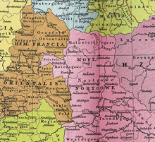
Since the 7th century AD, the landscape designation Nordgau encompassed the areas north of the Danube between Neuburg an der Donau and Regensburg , which were later extended to the Upper Main and, from 1060, into the Egerland . Over time, the area was under the rule of the Carolingians , the Luitpoldinger , the Margraves of Schweinfurt (939-1003), the Counts of Sulzbach and the Diepoldinger Rapotonen . At the end of the 12th century, the Counts of Wittelsbach gained a foothold, who in 1255 as Dukes of Bavaria were able to acquire the greater part of the area and incorporated it into their duchy. As a result of the Wittelsbach dichotomy in 1329, the name changed to Upper Palatinate . The ownership designation Nordgau can be documented for the first time under the Carolingians in the plans of the division of the empire of Charlemagne from 806 and Ludwig the Pious from 817 and 839.
Formation


After the period of migration , which gradually subsided since 450 AD, the history of the Eastern Franconia , documented by documentary sources, begins, the time of the formation of the Bavarians and the history of Bavaria . From these sources, the events of that time in the area to which today's Upper Palatinate, Lower, Middle and Upper Franconia belong, can be roughly traced. The Nordgau developed in the area called Francōnia orientālis north of the Danube and the Castra Regina as far as the Main and extended into the Bohemian Forest to the east. One of the old tribes known by name that settled there, besides the Celts and Armalausi, were the Variskers , who, according to the Tabula Peutingeriana , were resident in the emerging diocese of Regensburg and in Thuringia.
Chlodio , the first king of the Franks , had sovereignty in this landscape, which reached up to the borders of the Thuringian settlement area . The Thuringian region at that time lay east of the Franks and north of the Alamanni , extended to the Franconian Saale , the Main , the Tauber , the Werra river area and overlapped with settlement areas of West Slavic tribes in the Saale river area .
Under Emperor Charlemagne (768-814) the area was Francōniae orientālis , d. H. the river basins of the Main, the Regnitz and the Pegnitz to the Bohemian Forest , conquered and incorporated into the Franconian Empire. In the Reich Partition Act of 806, these areas, which his son Karl should inherit, were described in more detail. The Diedenhofen certificate of division of the empire shows that Charlemagne referred to the areas to the left of the central course of the Danube as far as the settlement areas of the Slavs as "Nordgaw": "pagum, qui dicitur Northgowe ..." (MGH Capit. 1, No. 45, p . 127), including the two courts of Ingolstadt ("Ingoldestadt") and Lauterhofen ("Luttarof"), which Duke Tassilo III. had a fiefdom from Bavaria. Charlemagne sent the certificate of division of the empire, which was signed by the Frankish followers personally and confirmed by oath of allegiance, as a gesture of submission and recognition of the supremacy of the Pope to the Vatican in Rome. The cancelarius of Charlemagne, Einhard , put them to Pope Leo III. (795–816) for approval and signature.
Structure of the administration
The missionary Boniface and his successors intensified Christianization . The Diocese of Regensburg (739), the Diocese of Würzburg (741), the Diocese of Eichstätt (741) and the Fulda Monastery (744) emerged in quick succession with the subsequent shifting of the boundaries of the individual dioceses . In the 8th century, an area between the Regnitz, the Franconian Schwabach, the Pegnitz and the Bohemian Forest as the eastern border from the administration of the diocese of Würzburg, which at that time comprised the three archdeaconates Volkfeld , Sualafeld and Ifgau, was annexed to the diocese of Eichstätt. From a Bavarian point of view, it was called Nordgau with the Pegnitz as the northern border. In this area separated from the Diocese of Würzburg, the Radenzgau developed under the successors of Emperor Charlemagne , in which the Diocese of Bamberg was established in 1007 under King Heinrich II .
During the emergence of the Holy Roman Empire and after the division of the empire in the 10th century, the northern part of the Radenzgau with the borderline of the Franconian Schwabach in the north, the course of the Regnitz in the west and that of the Pegnitz in the south ran in a straight line to Künische Mountains bounded in the east. After Heinrich II was coronated as emperor , part of the area was given to the Bamberg diocese as a gift . The early medieval pre-Christian population of the Nordgau was, as evidenced in chronicles and documents, by archaeological finds and the research results on the origin of the place, river and mountain names, of different ethnic origins; Celts , Western Slavs , Franks and Bavarians dominated.
During the High Middle Ages, the Nordgau expanded in the south with the Altmühltal to Neuburg and Ingolstadt , to the west to Nuremberg , to the east to the Naab and in the north with increasing settlement to the Egerland , which at that time consisted of the Eger basin , the later Sechsämterland and the Elsterland around the places Adorf and Markneukirchen (in what is now the Saxon Vogtland ) existed and belonged to the diocese of Regensburg.
Weißenburg in Bavaria (now part of Middle Franconia ) used to be called Weißenburg im Nordgau .
Decay
As early as the 11th century, changes in ownership of the northern Gau began when Diepold II von Vohburg and his son Diepold III. von Vohburg , Margraves in the Nordgau, expanded into the area of the Eger basin by colonization and secured it in 1125 by building an older Slavic castle on the castle hill in Eger . This castle and parts of the Egerland came into the possession of the Hohenstaufen in 1167 through inheritance to Emperor Barbarossa and thus for a longer period of time . With the impressively expanded Imperial Castle, the city of Eger received the status of an imperial city. After the Diepoldingern, parts of the Nordgau belonged to different noble families. The Counts of Wittelsbach succeeded in 1255 in including a large part of the northern Gau in their domain, but they no longer demarcated this area with the name Nordgau.
The old borders were further dissolved when Emperor Ludwig the Bavarian pledged the Egerland in the northeastern part of the Northern Gau to Bohemia in 1322 and in the Pavia house contract in 1329 handed over the greater part of his property in the Nordgau to the Rhineland-Palatinate line of the Wittelsbachers. Seen from the Rhine Palatinate, this led to the name “the Upper Palatinate” (Upper Palatinate), which was returned to the Electorate of Bavaria in 1628 under Maximilian I after the beginning of the Thirty Years' War and the re-Catholicization in Bavaria .
In the course of the following time, the name Nordgau was understood to mean a landscape area north of the Danube belonging to Baiern. The name lived on and kept alive a transfiguring memory of the old historical space. In the middle of the 16th century, in an appendix to a chronicle of the city of Eger ( Cheb ), the area around the city was referred to as "Nordgau", presumably to emphasize that it belonged to Bavaria, although the Egerland was no longer redeemed as a pledge and was in western Bohemia was incorporated. The dialect and the cultural character of the Egerländer are still similar to those of the Upper Palatinate.
Tradition and memory
- Since 1930 there have been regular Nordgau days , festivities in a traditional setting, with an interruption from 1936 to 1951. The 36th Nordgau Day was in Nittenau in 2006 , Tirschenreuth was the host in 2008, and due to the 975th anniversary of the city, there was a Nordgau Day in Amberg in the Upper Palatinate in 2009 .
- In 1956 the painter Franz Gruss received the Nordgau Culture Prize .
- In 1960 the historian Anton Ernstberger received the Nordgau plaque of honor.
- In 1969 the genealogist Adolf Fischer received the Golden Badge of Honor from the Upper Palatinate Working Group Bayerischer Nordgau .
- The Bavarian State Railways named a locomotive Nordgau. It is the oldest surviving locomotive in Germany ( Bayerische BV ) in the Nuremberg Transport Museum .
- The Bundeswehr barracks in Cham was named North Caucasus .
literature
- Gerhard Köbler : Historical lexicon of the German countries. The German territories from the Middle Ages to the present. 7th, completely revised edition. CH Beck, Munich 2007, ISBN 978-3-406-54986-1 , p. 436 (Nordgau (Gau, Landschaft)).
- Alois Schmid : Nordgau. In: Lexicon of the Middle Ages . 1993, p. 1235.
- Andreas Kraus: Marginalia on the oldest history of the Bavarian Nordgau. In: Yearbook for Franconian State Research. 34/35, 1974/75, pp. 163-184.
- Heribert Sturm : Nordgau Egerland Oberpfalz, studies on a historical landscape. Oldenbourg Verlag, Munich / Vienna 1984, ISBN 3-486-49541-0 .
- Ernst Gagel : The Nordgau in the Middle Ages. 1969, pp. 7-22. ( Upper Palatinate home 13)
- Ernst Schwarz : Language and Settlement in Northeast Bavaria. Nuremberg 1960. (Erlangen contributions to linguistics and art studies 4)
- Karl Siegl : The excavations on the imperial castle in Eger (grave finds of a West Slavic, pre-Christian population). In: Communications from the Association of the History of Germans in Bohemia. 1912, p. 258.
- Michael Doeberl: The margravate and the margraves in the Bavarian north gau. Munich / Bamberg 1893. (With information from older literature).
Individual evidence
- ^ Document of division of the Reich to Diedenhofen: Ann Max. Einhard, Fulda; see also the manuscript of St. Gallen 1975, Tom. III. pag.

