Brandberg (Tyrol)
|
Brandberg
|
||
|---|---|---|
| coat of arms | Austria map | |
|
|
||
| Basic data | ||
| Country: | Austria | |
| State : | Tyrol | |
| Political District : | black | |
| License plate : | SZ | |
| Surface: | 156.07 km² | |
| Coordinates : | 47 ° 10 ' N , 11 ° 54' E | |
| Height : | 1082 m above sea level A. | |
| Residents : | 362 (January 1, 2020) | |
| Postal code : | 6290 | |
| Area code : | 05285 | |
| Community code : | 7 09 03 | |
| NUTS region | AT335 | |
| Address of the municipal administration: |
Brandberg 13 6290 Brandberg |
|
| Website: | ||
| politics | ||
| Mayor : | Heinz Ebenbichler (General Brandberger List) | |
|
Municipal Council : (2016) (11 members) |
||
| Location of Brandberg in the Schwaz district | ||
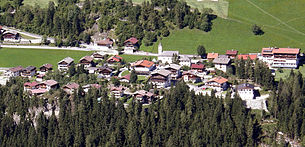
 Brandberg seen from the opposite side of the valley |
||
| Source: Municipal data from Statistics Austria | ||
Brandberg is a municipality with 362 inhabitants (as of January 1, 2020) in the Zillertal and belongs to the Schwaz district in Tyrol ( Austria ). The community is located in the judicial district of Zell am Ziller .
geography
Brandberg is located in the Zillergrund , a side valley of the rear Zillertal, which branches off at Mayrhofen and is traversed by the Ziller . The municipality takes up almost the entire Zillergrund and extends to the border with South Tyrol ( Italy ). The main town of the same name is about 200 m above the Ziller, while the rest of the settlement is characterized by several farms and hamlets . The community owes its sunshine all day to the south-exposed location. The highest farms are at around 1300 m above sea level. A nearby mountain is the Brandberger Kolm ( 2700 m ).
Community structure
Brandberg consists of a single cadastral municipality and village of the same name .
|
structure
|
||||||
|
Legend for the breakdown table
|
The districts of Pignellen, Steglach, Dorf, Windhag, Emberg, Stein, Ahornach, Gruben, Ritzl-Pötzmann, Nößlrain-Klaushof, Häusling, Au and Bärenbad belong to the municipality.
Neighboring communities
Four of the six neighboring communities are in the Schwaz district.
| Ramsau im Zillertal and Hainzenberg | Gerlos | |
| Mayrhofen |

|
Krimml (Zell am See / Salzburg district) |
| Prettau (South Tyrol) |
history
The name Brandberg (formerly known as Pramberg, Pramach) is derived either from blackberry lash or from slash and burn. In the 12th century, the Archbishop of Salzburg cultivated the Brandberg in a single clearing operation. At that time, five Schwaigen (cattle farms) were established, which had to pay the responsible Maierhof interest and taxes in kind. It was operated with the South Tyrolean Ahrntal exchange economy over the Jöcher. The Schwaighöfe were gradually divided.
Until 1801 Brandberg was a separate tax and administrative district, to which Mayrhofen also belonged.
In 1837 427 Zillertal inclinants had to leave their homeland. Among them were 89 people from Brandberg, which corresponded to almost a third of the population. 416 emigrated to Lower Silesia, eleven of them to Carinthia and Styria to existing tolerance communities .
In 1960 the road connection was expanded to stimulate tourism. In 1987 the Zillergründl storage facility was completed.
Population development

coat of arms
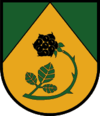
In 1984 the municipality of Brandberg was given a municipal coat of arms. It shows a golden tip in green, inside a green blackberry stem with leaves and black fruit.
economy
The main sources of income are agriculture and tourism, with Brandberg promoting gentle tourism in contrast to Mayrhofen, for example. The generation of electrical energy (Zillergründl storage facility with power plant) also plays a role. In the side valleys of the Zillergründl, there is mainly seasonal alpine farming.
In the area of the community there are two mountain huts ( Kolmhaus 1845 m and Plauener hut 2373 m ).
Culture and sights
- Catholic Parish Church of the Holy Cross
- Maria Schnee local chapel
traffic
Two routes lead from Mayrhofen to Brandberg. One is known as the gorge route, the second and more modern leads through the Brandberg tunnel, a tunnel from Hollenzen (a district of Mayrhofen) towards Zillergrund and then on to Brandberg. In the meantime, however, the renovation and widening of the section of the gorge, which was previously in a relatively poor state of construction, has been tackled. The Zillertalbahn has its terminus in Mayrhofen, from there there is bus service.
Sons and daughters of the church
- Hans Schneeberger (1895–1970), cameraman
Web links
- 70903 - Brandberg. Community data, Statistics Austria .
- History-Tyrol: Brandberg
- Community website


