
Kaiseraugst
| Kaiseraugst | |
|---|---|
 |
|
| State : |
|
| Canton : |
|
| District : | Rheinfelden |
| BFS no. : | 4252 |
| Postal code : | 4303 |
| UN / LOCODE : | CH KGT |
| Coordinates : | 621.47 thousand / 265 582 |
| Height : | 269 m above sea level M. |
| Height range : | 255–383 m above sea level M. |
| Area : | 4.90 km² |
| Residents: | 5537 (December 31, 2019) |
| Population density : | 1130 inhabitants per km² |
|
Proportion of foreigners : (residents without citizenship ) |
29.1% (December 31, 2019) |
| Website: | www.kaiseraugst.ch |
 Village center of Kaiseraugst |
|
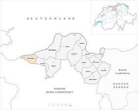
| Location of the municipality | |
  |
|
Kaiseraugst ( Swiss German : Chäiseraugscht ˈχæisəɾˌɑuɡʃt ) is a municipality in the Swiss canton of Aargau . It belongs to the Rheinfelden district and is located in the west of the Fricktal region and in the extreme northwest of the canton. The community is one of the fastest growing residential and industrial areas in the Basel metropolitan region , is located on the Upper Rhine and borders Germany and the canton of Basel-Landschaft . The place is known because of the former Roman city of Augusta Raurica .
geography
The community lies on the southern edge of the Upper Rhine Plain . The partially meandering Violenbach cuts through the one kilometer wide gravel plain in a 20 meter deep ditch and flows into the Ergolz , which in turn flows into the Rhine . Both streams form the border with the canton of Basel-Landschaft and the municipality of Augst . The old center is located directly on the banks of the Rhine, another historical part of the village is on the Ergolzbrücke. Most of the population lives in the Liebrüti settlement, which was built in the 1970s between the railway line and the Violenbach. To the east of it there are extensive industrial plants. In the far south-east rise the wooded foothills of the Table Jura .
The area of the municipality is 490 hectares , 160 hectares of which are forested and 209 hectares are built over. The highest point is 382 m above sea level. M. in Zankholz, the deepest at 261 m above sea level. M. at the confluence of the Ergolz into the Rhine; this is also the lowest point in the entire canton of Aargau. Neighboring communities are Augst in the west, Giebenach in the south, Olsberg in the east and Rheinfelden in the northeast. In the north, Kaiseraugst borders the German communities Grenzach-Wyhlen and Rheinfelden (Baden) .
history

The name Augst goes back to the Roman city of Augusta Raurica and refers to the Celtic tribe of the Rauriks . The older upper town was built on the terrace spur between Ergolz and Violenbach, in the area of today's municipality of Augst . It was born in 45 BC. Founded in BC, it is the oldest Roman settlement in Switzerland. Around 100 AD , the lower town with a river port, craftsmen's quarters and trading facilities was built on the Rhine in the area of today's Kaiseraugst.
After the upper town was destroyed by the Alamanni around 273/74 , the Romans built a fort in the lower town , the Castrum Rauracense , which served as the headquarters of the Legio I Martia . After the Roman troops withdrew at the beginning of the 5th century, the fort remained inhabited. For 346 it was mentioned in a tradition of the 9th century as the seat of a bishop, but this report to a council is a subsequent compilation and, viewed from a source critique, almost worthless. When the diocese moved its seat to Basel in the 7th century , the settlement lost its importance. Demolition material from the dilapidated Upper Town was used to build the mighty “Heidenmauer” around the fort. Over time, the heath wall was perforated and used as a quarry.
In the Middle Ages , a new settlement focus had formed on both sides of the Ergolzbrücke, where the customs and a mill were located. In 1442 the Ergolz and the Violenbach became the border: the western part of the settlement first came under the rule of Farnsburg and in 1461 finally became the property of the city of Basel . The eastern part of the settlement came into the possession of the Habsburgs , initially called Augst in the village and a little later Kaiseraugst. After the Waldshut War of 1468, the Habsburgs pledged the entire Fricktal to Burgundy . When the Burgundians were defeated by the Confederates during the Burgundian Wars , Kaiseraugst came under Habsburg rule again in 1477.
After the imperial reform of the Austrian Emperor Maximilian I in 1491, Kaiseraugst belonged to Upper Austria and was located in the Möhlinbach region , a subordinate administrative unit of the Rheinfelden cameramen (from 1752 in the Oberamt Breisgau ). In the 17th century there were hardly any longer times of peace. The Rappenkrieg , a peasant uprising, lasted from 1612 to 1614. The Thirty Years War , which also affected the Fricktal between 1633 and 1638, threw the village back in its economic development. Foreign troops also moved through the region during the War of the Palatinate Succession (1688–1697).
In 1797 the Fricktal became a French protectorate after the Peace of Campo Formio . During the Second Coalition War , the front line between the armies of France and Austria ran here . On February 20, 1802, Kaiseraugst became a municipality in the Rheinfelden district of the Fricktal canton , which joined the Helvetic Republic in August . The municipality has belonged to the canton of Aargau since February 19, 1803.
As early as 1500 the fishermen between Hüningen and Säckingen had formed the Rhine cooperative, which was soon joined by boatmen and raftsmen. Mostly Kaiseraugster occupied the highest posts in this association. The fishery developed in the 17th and 18th centuries to the main commercial. Until the widespread introduction of the railway in the 19th century, rafting was also of great importance, with Kaiseraugst being an important transshipment point.

The industrial age in Kaiseraugst began in 1841 with the first test drilling for salt and with the opening of the first saltworks in 1843. On August 2, 1875, the Bözberg railway between Basel and Brugg was opened . The first cellulose factory in Switzerland started operations in 1888 . Shortly after construction of the Augst-Wyhlen hydropower plant began, the salt works were closed in 1909, and the power plant began producing electricity in 1913.
From the mid-1960s, Kaiseraugst experienced an unprecedented boom. After the construction of the motorways , numerous industrial companies settled here, including a large production facility for the Hoffmann-La Roche chemical company . The new Liebrüti part of the village was built south of the railway line. Since then, the number of inhabitants has increased by almost five times. In the first five years of the 21st century, new settlement areas were created east of the Liebrüti.
For a long time, the community was under discussion as the location for the Kaiseraugst nuclear power plant . The project failed due to the bitter resistance of the population and environmental groups. The most spectacular event in 1975 was an eleven week occupation of the building site. In 1988 the project was finally dropped.
coat of arms
The blazon of the municipal coat of arms reads: "White Roman watchtower with red, black joints, covered in white." A square uncovered tower was depicted on the municipal seal from 1811, reminiscent of the Roman forts along the Rhine. From 1915, the version still used today existed in parallel, and was declared binding by the local council in 1960.
Attractions

The old village center of Kaiseraugst was built within the “Heidenmauer”, the fortification of the late Roman “Castrum Rauracense”. This wall was up to four meters thick and eight to ten meters high. There were at least 18 towers and four gates. Most of it has disappeared, but the southwest corner is still particularly well preserved.
On the north side, on the banks of the Rhine, archaeologists uncovered a public bathing complex in 1974/75, the hypocaust is particularly worth mentioning. In 1962, the late Roman silver treasure from Kaiseraugst , consisting of richly decorated plates, drinking vessels, cutlery, 186 silver coins and medallions, was discovered during construction work on the southern fort wall . These objects, which were buried there during an onslaught of enemy troops, are on display in the Roman Museum in Augst .
At the Violenbach, near the country road, you can see well-preserved remains of a Roman trading and industrial building including a brick kiln. Two more brick kilns are on the edge of the Liebrüti settlement. In a wooded area south of the motorway, a tunnel-like part of a Roman aqueduct has been preserved.
In the center of the village is the Christian Catholic Church of St. Gallus . During the Kulturkampf , the majority of the population changed to the Christian Catholic denomination, which is why the Roman Catholics built their own church in 1900/01.
photos

SBB train station

Village center
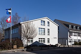
Local government

village street

Liebrüti, shopping center

Liebrüti


population
The population developed as follows:
| year | 1758 | 1850 | 1900 | 1930 | 1950 | 1960 | 1970 | 1980 | 1990 | 2000 | 2010 |
| Residents | 215 | 405 | 595 | 719 | 852 | 995 | 1311 | 3044 | 3568 | 3917 | 5242 |
On December 31, 2019, 5537 people lived in Kaiseraugst, the proportion of foreigners was 29.1%. In the 2015 census, 27.0% described themselves as Roman Catholic , 19.7% as Reformed and 1.1% as Christian Catholic ; 52.2% were non-denominational or of other faiths. In the 2000 census, 88.2% stated German as their main language, 2.2% Italian , 1.8% French , 1.3% English , 1.0% Serbo-Croatian and Spanish and 0.9% Albanian .
Politics and law
The assembly of those entitled to vote, the municipal assembly , exercises legislative power. The executing authority is the five-member municipal council . He is elected by the people in the majority procedure, his term of office is four years. The parish council leads and represents the parish. To this end, it implements the resolutions of the municipal assembly and the tasks assigned to it by the canton. The Rheinfelden District Court is the first instance responsible for legal disputes . Kaiseraugst belongs to the Friedensrichterkreis XIV (Rheinfelden).
economy
According to the corporate structure statistics (STATENT) collected in 2015, Kaiseraugst has around 5,200 jobs, less than 1% of them in agriculture, 67% in industry and 32% in the service sector. By far the largest employer is the pharmaceutical company Hoffmann-La Roche . There are also numerous small and medium-sized companies. Many workers are commuters and work in the city or agglomeration of Basel. A substation from Atel Holding and Axpo Power is located in Asphard . There, electrical energy with a nominal voltage of 380 kV is transformed between Laufenburg , the Basel agglomeration, the Kühmoos and Sierentz .
traffic

Kaiseraugst has excellent transport links. Hauptstrasse 3 runs through the community between Basel and Zurich . On the main road 2 to Liestal , about two kilometers away, there is a junction for the A2 motorway . To the south of the village is a motorway triangle where the A3 begins. On March 7, 2006, the 4.6 km long A861 was opened; it begins on the border with Rheinfelden , crosses the Rhine and leads to the A98 .
Kaiseraugst train station is on the SBB - Bözberg route between Basel and Zurich. The S1 line of the Basel S-Bahn , which runs from Basel SBB train station to Frick or Laufenburg , stops here . The village is accessed by two AAGL lines that run from Pratteln to Liestal and the Kaiseraugster train station to Rheinfelden. On weekends there is a night S-Bahn from Basel through the Fricktal to Brugg and a night bus from Basel via Kaiseraugst to Arisdorf . On the Rhine, excursion boats run by Basel Passenger Shipping to Basel and Rheinfelden, and the Kaiseraugst – Herten ferry to Germany.
education
The community has five kindergartens and two school houses in which the primary school , the junior high school and the secondary school are taught. The district school can be attended in Rheinfelden . On the basis of an inter-cantonal agreement, young people from parts of the Fricktal can complete high school in Muttenz (Canton Basel-Landschaft) or in Basel .
Personalities
- Gregor Lützelschwab (1794–1860), councilor and judge
literature
- Martin Hartmann, Dominik Sauerländer: Kaiseraugst. In: Historical Lexicon of Switzerland .
- René Salathé, et al .: Augst and Kaiseraugst: Two villages - one story . Verlag des Kantons Basel-Landschaft, Liestal 2007, ISBN 978-3-85673-671-2 .
- Michael Schroeren : For example Kaiseraugst - The nonviolent resistance against the nuclear power plant. From legal protest to civil disobedience. Swiss Peace Council, Zurich 1977. (Case study on the citizens' movement against the construction of a nuclear power plant in Kaiseraugst)
- Edith Hunziker, Peter Hoegger: The art monuments of the canton of Aargau . Ed .: Society for Swiss Art History . Volume IX, Rheinfelden district. Bern 2011, ISBN 978-3-906131-94-8 , pp. 289-312 .
Web links
Individual evidence
- ↑ Cantonal population statistics 2019. Department of Finance and Resources, Statistics Aargau, March 30, 2020, accessed on April 2, 2019 .
- ↑ Cantonal population statistics 2019. Department of Finance and Resources, Statistics Aargau, March 30, 2020, accessed on April 2, 2019 .
- ↑ a b Beat Zehnder: The community names of the canton of Aargau . In: Historical Society of the Canton of Aargau (Ed.): Argovia . tape 100 . Verlag Sauerländer, Aarau 1991, ISBN 3-7941-3122-3 , p. 213-216 .
- ^ National map of Switzerland, sheet 1068, Swisstopo.
- ↑ Standard area statistics - municipalities according to 4 main areas. Federal Statistical Office , November 26, 2018, accessed on May 11, 2019 .
- ^ Joseph Galliker, Marcel Giger: Municipal coat of arms of the Canton of Aargau . Lehrmittelverlag des Kantons Aargau, book 2004, ISBN 3-906738-07-8 , p. 186 .
- ↑ Population development in the municipalities of the Canton of Aargau since 1850. (Excel) In: Eidg. Volkszählung 2000. Statistics Aargau, 2001, archived from the original on October 8, 2018 ; accessed on May 11, 2019 .
- ↑ Resident population by religious affiliation, 2015. (Excel) In: Population and Households, Community Tables 2015. Statistics Aargau, accessed on May 11, 2019 .
- ↑ Swiss Federal Census 2000: Economic resident population by main language as well as by districts and municipalities. (Excel) Statistics Aargau, archived from the original on August 10, 2018 ; accessed on May 11, 2019 .
- ↑ circles of justice of the peace. Canton of Aargau, accessed on June 19, 2019 .
- ↑ Statistics of the corporate structure (STATENT). (Excel, 157 kB) Statistics Aargau, 2016, accessed on May 11, 2019 .