
Corneşti (Cluj)
|
Cornești Magyarszarvaskend |
|||||
|
|||||
| Basic data | |||||
|---|---|---|---|---|---|
| State : |
|
||||
| Historical region : | Transylvania | ||||
| Circle : | Cluj | ||||
| Coordinates : | 47 ° 2 ' N , 23 ° 41' E | ||||
| Time zone : | EET ( UTC +2) | ||||
| Height : | 342 m | ||||
| Area : | 83 km² | ||||
| Residents : | 1,493 (October 20, 2011) | ||||
| Population density : | 18 inhabitants per km² | ||||
| Postal code : | 407250 | ||||
| Telephone code : | (+40) 02 64 | ||||
| License plate : | CJ | ||||
| Structure and administration (as of 2016) | |||||
| Community type : | local community | ||||
| Structure : | Cornești, Bârlea , Igriția , Lujerdiu , Morău , Stoiana , Tiocu de Jos , Tiocu de Sus , Tioltiur | ||||
| Mayor : | Dorel-Florinel Julean ( PSD ) | ||||
| Postal address : | Str. Principală, no. 14 loc. Corneşti, jud. Cluj, RO-407250 |
||||
| Website : | |||||


Cornești [ corˈneʃtʲ ] ( Hungarian Magyarszarvaskend ) is a municipality in Cluj County , in Transylvania , Romania .
The place is also known by the Romanian old names Chendru and Chendu , and the Hungarian Szarvaskend and Kend .
Geographical location

The municipality of Corneşti is located in the Somesch Highlands (Podişul Someşan) south of the 693 m high Bobâlna mountain in the west of the Transylvanian Basin . The highest village in the municipality is the village of Igriția (ung. Kisigrice ) at 441 m . The community center is located on the Lujerdiu brook - a left tributary of the Someșul Mic (Little Somesch) - and on the district road (Drum județean) DJ 109B, about 28 kilometers east of the town of Gherla ( New Castle ) and about 45 kilometers from the district capital Cluj- Napoca (Cluj) away.
history
Corneşti was first mentioned in a document in 1305 or 1306. In the Middle Ages the place was owned by the Hungarian noble family Kendi . Archaeological finds in the area of the village of Corneşti, known by the locals as La Cetate , and in the incorporated village of Tioltiur (Hungarian Tötör ) point back to prehistory .
In the Kingdom of Hungary , today's municipality belonged to the Szamosújvár chair district in the Szolnok-Doboka County , then to the historical Someș district and, from 1950, to today's Cluj district.
population
The population of the municipality developed as follows:
| census | Ethnic composition | ||||
|---|---|---|---|---|---|
| year | population | Romanians | Hungary | German | other |
| 1880 | 3,553 | 2,860 | 590 | - | 103 |
| 1930 | 4,984 | 4.138 | 702 | - | 144 |
| 1956 | 5,662 | 4,896 | 755 | - | 11 |
| 2002 | 1,809 | 1,516 | 265 | - | 28 |
| 2011 | 1,493 | 1,196 | 187 | 2 | 108 (Roma 51) |
Since 1880 the highest number of inhabitants and that of the Romanians in 1956 have been determined in the area of today's municipality. The highest population of the Magyars (1,184) was registered in 1941, that of the Roma (55) in 1930 and that of the Romanian Germans (95) in 1910.
1930 the residents of the Corneşti community of the Greek Catholic , Roman Catholic and Reformed , and two residents of the incorporated town of Tiocu de Jos (ung. Alsótök ) of the Greek Orthodox confession.
Attractions
- In Corneşti the Roman Catholic Church Sf. Maria Mare , built in 1725, is a Gothic building with a baroque style interior and is a listed building.
- The church Sfinții Arhangheli Mihail și Gavriil, built in the 16th century in the incorporated village of Lujerdiu (ung. Lózsárd ) , is a listed building.
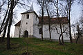
- In the incorporated village of Stoiana (ung. Esztény ) the reformed church built in the 15th century is a listed building.
- In the incorporated village of Tiocu de Jos, the reformed church built in the 14th century and the bell tower built in the late 18th and early 19th century are listed as historical monuments.
- In the incorporated village of Tiocu de Sus (ung. Felsötök ) the reformed church built in the 13th century and rebuilt in the 15th century is a listed building.
- In the incorporated village of Tioltiur, the orthodox church built in the 16th century and rebuilt in the 18th century and the wooden church Sfinții Arhangheli Mihail și Gavriil built in 1800 are under monument protection.

Town hall in Corneşti
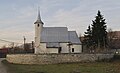
Church in Corneşti
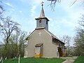
Church in Lujerdiu

Church in Bârlea

Church in Igriția

Church in Stoiana

Church in Tiocu de Jos
Church in Tiocu de Jos

Wooden church in Tioltiur

Church in Tioltiur


.JPG)
.JPG)

Web links
Individual evidence
- ↑ 2011 census in Romania ( MS Excel ; 1.3 MB)
- ↑ Corneşti at arcanum.hu
- ↑ Information on the municipality's website , accessed on October 1, 2017 (Romanian).
- ↑ a b Heinz Heltmann, Gustav Servatius (Ed.): Travel Guide Siebenbürgen . Kraft, Würzburg 1993, ISBN 3-8083-2019-2 , p. 517 .
- ^ Institute Of Archeology - Cornești , accessed October 1, 2017 (Romanian).
- ↑ Institute Of Archeology - Tioltiur , accessed on October 1, 2017 (Romanian).
- ↑ Censuses 1850–2002, last updated November 2, 2008 (PDF; 1 MB; Hungarian)
- ^ Document at wikimedia.org
- ↑ a b c d e f List of historical monuments of the Romanian Ministry of Culture, updated 2015 (Romanian; PDF; 12.7 MB)
Aghireșu | Aiton | Aluniș | Apahida | Aşchileu | Baciu | Băișoara | Beliș | Bobâlna | Bonțida | Borșa | Buza | Căianu | Călărași | Călățele | Cămărașu | Căpușu Mare | Cășeiu | Câțcău | Cătina | Ceanu Mare | Chinteni | Chiuieşti | Ciucea | Ciurila | Cojocna | Cornești | Cuzdrioara | Dăbâca | Feleacu | Fizeșu Gherlii | Florești | Frata | Gârbău | Geaca | Gilău | Iara | Iclod | Izvoru Crișului | Jichișu de Jos | Jucu | Luna | Măguri-Răcătău | Mănăstireni | Mărgău | Mărișel | Mica | Mihai Viteazu | Mintiu Gherlii | Mociu | Moldoveneşti | Negreni | Pălatca | Panticeu | Petreștii de Jos | Ploscoș | Poieni | Râșca | Recea-Cristur | Săcuieu | Sâncraiu | Sănduleşti | Sânmărtin | Sânpaul | Săvădisla | Sic | Suatu | Țaga | Tritenii de Jos | Tureni | Unguraș | Vad | Valea Ierii | Viișoara | Vultureni