Cumbel
| Cumbel | ||
|---|---|---|
| State : |
|
|
| Canton : |
|
|
| Region : | Surselva | |
| Political community : | Lumnezia | |
| Postal code : | 7142 | |
| former BFS no. : | 3592 | |
| Coordinates : | 734 099 / 176 588 | |
| Height : | 1138 m above sea level M. | |
| Area : | 4.46 km² | |
| Residents: | 238 (December 31, 2012) | |
| Population density : | 53 inhabitants per km² | |
| Website: | www.lumnezia.ch | |
|
Cumbel |
||
| map | ||
|
|
||
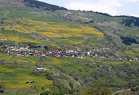
Cumbel ( , German and until 1983 officially Cumbels ) was an independent political municipality in the Val Lumnezia in the former Surselva district of the canton of Graubünden in Switzerland until December 31, 2012 . The former autonomous municipality of Cumbel bordered Duvin , Luven , Morissen , Pitasch , Sevgein , Suraua and Vella .
On January 1, 2013, it merged with the municipalities of Degen , Lumbrein , Morissen , Suraua , Vignogn , Vella and Vrin to form the new municipality of Lumnezia .
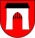
coat of arms
Blazon : In red the silver (white) women's gate ( Porclas ) with a black portcullis
The Frauentor is the most famous historical monument in the valley. It got its name from the legendary struggle of the Lugnez women during the Werdenberg-Belmont feud in 1352, when, according to a legend from the 18th century, the brave Lugnez women had routed a group of circumventing the enemy near Porclas . Outside Porclas, above the valley road on the former municipality and district boundary, there is a 160 centimeter high boundary stone from 1715. On the Lugnezer side, Saint Mauritius is depicted and the inscription: JOHAN HEINRICH VON MONT CURRENTLY LANDTAMEN IN LANGNETZ HAS LASEN THIS MARGSTEIN FROM BEF ELCH A WOLWISEN RATHS DESSELBSTEN 1715. The stone bears the Ilanz coat of arms towards the valley . As Landammann the Gruob is Piter Antoni Castell St. Nazaro called. In the hamlet of Valgronda, there is a sculpture ("La Pedra") by the Mexican artist Paloma Torres based on the drawing stones and prehistoric found stones found in Lugnez.
geography
Cumbel is a street village on the southwest slope of Piz Mundaun and has been politically a fraction or neighborhood of the valley community Lumnezia since 2013. Of the entire former municipal area of 445 hectares, 207 hectares were used for agricultural purposes, 203 hectares of forest and wood, 24 hectares of settlement area and 11 hectares of unproductive area (mountains). The climate is continental-alpine, sunny and low in precipitation. Geologically, Cumbel lies on a tectonic sliding slope, similarly unstable as in the Peiden below , but not as pronounced. The townscape is characterized by a few wooden houses full of character and a hillside location with the most beautiful view of the opposite side of the valley and the Piz Signina mountain range. In the village part of Lischeinas the village image was expanded with architectural diversity in the 1990s. Since then, second homes and new buildings have been built in connection with the tourist boom in the Lugnez Valley. In the area of infrastructure, Cumbel worked closely with the neighboring town of Morissen early on . For example, in 1973 a retirement home was opened for the valley, which today serves as a hotel and a joint school was built in Cuschnaus. In 1993 Cumbel received an award from the Solar 91 consortium for the installation and use of solar collectors. Jobs are still offered today in agriculture, trade, the service sector and tourism.
history
The first documentary mention of Cumbel comes from the imperial surbar Ludwig the Pious around 840, and the Mauritius church in Valgronda is also mentioned. Archaeologically there are traces of earlier settlement in the form of four pre-Christian graves. As in the rest of the Val Lumnezia, Roman traces are sparse, limited to pieces of coins and broken pieces. There is evidence of a royal manor in the Middle Ages, which over time passed to the Bishop of Chur. In 1345 Cumbel was named in a papal letter of indulgence with other Lugnez churches as independent units. In 1538 the rulership rights were bought out. From this date Cumbel together with Peiden and Camuns formed their own neighborhood in a judicial parish of Alt Fry Rätia. This fact remained until the introduction of the cantonal constitution in 1854. In 1653 the Catholic parish broke away from the mother church of Pleif. Capuchins of the Rhaetian Mission worked in the region from 1649 to 1924 . They had a great influence on the local culture, the building of churches, including the Church of St. Stephen, and even on the literary field. In 1872/73 the valley road from Ilanz to Cumbel was expanded, it had a branch to Peiden and Vals. In 1886 the road to Vrin was expanded and made safe for the stagecoach service. This expansion also promoted tourism and the connection to the regional center of Ilanz . In 1927 the first post bus drove through Cumbel towards Vrin. With the construction of the mountain railways and ski lifts in the Vella valley center in 1970, the real tourist boom began in Cumbel as well as in the rest of the valley.
Others
To the southeast of the village, in the district of Valgronda , above the valley road stands the lovely St. Murezi chapel .
population
| Population development | |||||||||
|---|---|---|---|---|---|---|---|---|---|
| year | 1850 | 1900 | 1910 | 1941 | 1950 | 1990 | 2000 | 2004 | 2012 |
| Residents | 278 | 342 | 275 | 331 | 298 | 257 | 288 | 270 | 238 |
Of the 270 residents at the end of 2004, 263 were Swiss citizens. It is Sursilvan spoken.
Personalities
- Johann Bartholome Arpagaus (1810–1882), national councilor, government councilor and health resort doctor
- Zacharias da Salò (1615- ???), spiritual writer and typographer, promoter of the Romance language
Attractions
Chapel of St. Murezi near Cumbel
St. Maurizius at the old schoolhouse. Lower left the Porclas , upper right the St. Murezi Chapel
literature
- Adolf Collenberg: Cumbel. In: Historical Lexicon of Switzerland . 2016 .
Web links
Individual evidence
- Duri Blumenthal, Armin Caduff, Curdin Casaulta, Peter Schmid: Kulturführer Val Lumnezia and Vals, Vella 2000, p. 99f.
- Duri Capaul et al. a .: Lumnezia and Valsertal. Swiss homeland books 131, Bern 1987


