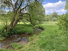
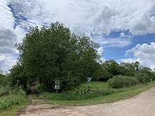
Glaadtbachtal with tributaries
|
Glaadtbachtal with tributaries
|
||
|
Glaadtbachtal |
||
| location | Dahlem , Germany | |
| WDPA ID | 163256 | |
| FFH area | 72.4 ha | |
| Geographical location | 50 ° 22 ' N , 6 ° 33' E | |
|
|
||
| Setup date | 1985 | |
The nature reserve Glaadtbachtal with tributaries is located in the area of the municipality of Dahlem in the district of Euskirchen in North Rhine-Westphalia .
location
The area extends south-southeast of the core town of Dahlem on the border with Rhineland-Palatinate and includes the Glaadtbach as well as the Haubach , Wilsenbach and Luttersbach . It consists of a total of three individual areas through which the Eifel route Cologne - Euskirchen - Gerolstein - Trier runs in a north-south direction.
meaning
Since 1985, an area of 72.4 ha has been designated as a nature reserve for Dahlem under the identification number EU-024. The area was placed under protection in order to preserve and develop the habitat for several animal and plant species endangered according to the Red List in North Rhine-Westphalia . According to the ordinance, another purpose is to “maintain and optimize the area as a well-developed biotope complex with biotopes endangered in North Rhine-Westphalia”. The aim is to preserve the habitat and retreat of endangered animal and plant species.
Area description
The first sub-area is on the southeastern edge of Dahlem and there east of the Obermühle and south of the Margaretenhof. There are wet and poor pastures that lie fallow on the western slope and are intensively grazed in the lower half. Ash willow and aspen thrive on the upper spring corridor .
The second sub-area is located in the southeast around the Haubach, an approximately 1.3 km long tributary of the Glaadtbach. It flows through fallow grassland and spruce forests. Blueberries and raspberries grow on the banks of the spring area, while the further course is covered with spruce. Meadowsweet and hogweed thrive in the grassland areas in the middle section ; some sections are used for agriculture by fish ponds.
The third and largest area in terms of area extends along the Glaadtbach and the Lutterbach. In this area there is a sewage treatment plant with three sewage ponds in the northeast . The Glaadtbach has been straightened in this part. The floodplain lies largely fallow and is only grazed in the northern part. While on the western side of the railway line predominantly poor willows and individual bushes grow, on the eastern side mainly alders and willows thrive. In the area around the Lutterbach, most of the land lies fallow, while the areas around the north Wilsenbach are used for agriculture.
Protection goals and risk
The area was placed under nature protection in order to preserve and optimize a "valuable source area with a natural stream and valuable grassland area". The grassland fallow land should be preserved, as well as the wet and wet meadows, the limestone grasslands and the rough meadows.
The State Office for Nature, Environment and Consumer Protection in North Rhine-Westphalia (LANUV) sees numerous threats, including disturbances from fertilization, water abstraction, fishing, excessive grazing and the spread of non-indigenous trees. Measures to avoid these impairments, among other things, from the point of view of the LANUV, should limit fishing, avoid extensive grassland management and avoid road construction measures.
See also
Web links
- Nature reserve “Glaadtbachtal with tributaries” in the specialist information system of the State Office for Nature, Environment and Consumer Protection in North Rhine-Westphalia
- World Database on Protected Areas - Glaadtbachtal with tributary streams (English)


