
Ullstadt
|
Ullstadt
Sugenheim market
Coordinates: 49 ° 37 ′ 0 ″ N , 10 ° 28 ′ 38 ″ E
|
|
|---|---|
| Height : | 300 (299–327) m above sea level NHN |
| Residents : | 387 (May 25 1987) |
| Incorporation : | May 1, 1978 |
| Postal code : | 91484 |
| Area code : | 09164 |
 The center of Ullstadt
|
|

Ullstadt is a district of the Sugenheim market in the Neustadt an der Aisch-Bad Windsheim district in Middle Franconia .
Geographical location
The parish village is on the Ehebach , a left tributary of the Aisch , and on the Hüßbach, which flows into the Ehebach as a left tributary in the village. Approx. The Grubsberg ( 388 m above sea level ) rises 1 km to the north, the Rote Berg ( 406 m above sea level ) and the Jewish tendrils rise about 0.5 km to the south . Approx. The Buchboden corridor area is 0.75 km to the west. The state road 2256 leading to Sugenheim (3 km southwest) or to Langenfeld (2.5 km east). The district road NEA 30 runs to the B 8 near Unterlaimbach (2.8 km north).
history
Ullstadt was probably founded during the so-called Franconian conquest in the 6th century. North of Ullstadt, on the Laimbach, was probably the Benedictine monastery Megingaudshausen (Megingaudeshausen, Meingozhausen), which was founded by the Mattonen in 816 , but was given up again around 877 when the monks moved to Münsterschwarzach . Ullstadt was first mentioned by name in this charter. The defining word of the place name is probably the personal name "Uligo", which can be seen as the founder of the place.
In the Staufer period there were possessions of the noble lords of Speckfeld , then the lords of Hohenlohe and their heirs in 1412, the Counts of Castell . North of Ullstadt lies the large, multi-section castle stable Kropfsberg, which was probably named after the low nobility "von Kropf". There was already a moated castle in the village in the late Middle Ages. Gradually, the von Seckendorff gentlemen acquired property and lordship rights in the village area and built a closed rulership complex, which they sold to the Freiherr von Franckenstein in 1662 because of economic difficulties as a result of the Thirty Years' War . Florian von Seckendorff had already employed Protestant clergy in Ullstadt in 1524. In 1533 he was then committed to the Augsburg Confession and thus officially carried out the Reformation . The last Catholic and first Protestant pastor was Johannes Nagel. Unlike in other places in the area, only a comparatively few Protestant religious expellees from Austria settled there after the end of the war and carried out the reconstruction. From 1718 to 1725 the Catholic Franckenstein had the old moated castle converted into a representative castle according to plans by the master builder Johann Dientzenhofer . In 1742, the Prince-Bishop of Bamberg, Johann Philipp Anton von Franckenstein, had a cozy, monumental courtyard built, for which the sculptor Ferdinand Dietz supplied the figures and trophies.
The castle with the castle garden and its rococo - Salettl is still one of the family to and from Franckenstein.
This family from Bergstrasse in the Odenwald belonged to the Catholic imperial knighthood nobility. From 1552 to 1560 Rudolf von Frankenstein was Bishop of Speyer, from 1746 to 1753 Johann Philipp von Franckenstein was Prince-Bishop of Bamberg, other Frankenstein were canons e.g. B. in Würzburg or Worms. In the second half of the 19th century and in the 20th century, the Frankenstein played a certain role as Bavarian center and CSU politicians.
Towards the end of the 18th century there were 60 properties in Ullstadt (castle with farm buildings, old castle, church, parsonage, synagogue, schoolhouse, tavern, bath room, forge, small Welsh house, village mill, brick factory, 3 courtyards, 36 estates, 8 estates, 4 houses, 6 houses). The high court exercised the rule of Ullstadt. The manor Ullstadt held the village and community rulership as well as the land rulership over all properties.The rule of Ullstadt belonged to the barons von und zu Frankenstein at that time . She exercised the high court and the village and community rule over Buchhof , Hohenholz , Lamprechtsmühle , Langenfeld and Wiesenmühle . In addition to the 60 properties in Ullstadt, she was also the landlord in Buchhof (1 property), Dottenheim (1), Herpersdorf (1), Hohenholz (3), Hürfeld (2), Iphofen (1), Lamprechtsmühle (1), Langenfeld (66 ), Neundorf (2), Oberlaimbach (24), Obernesselbach (2), Schauerheim (2), Unteresselbach (18) and Wiesenmühle (1).
In 1810 Ullstadt came to the new Kingdom of Bavaria . As part of the municipal edict, the Ullstadt tax district was formed in 1811 , to which Buchhof , Hohenholz , Lamprechtsmühle , Langenfeld and Wiesenmühle belonged. In 1813 the rural community Ullstadt was formed, which was congruent with the tax district. With the second community edict (1818), the rural community was split into
- Rural community Langenfeld with Hohenholz, Lamprechtsmühle;
- Rural community of Ullstadt with a book yard and meadow mill.
The administration and jurisdiction of the rural community Ullstadt was subordinate to the district court Neustadt an der Aisch and the financial administration to the rent office Neustadt an der Aisch . The Ullstadt Patrimonial Court held the voluntary jurisdiction and local police until 1848 . On February 12, 1827, the community was handed over to the Markt Bibart district court and the Iphofen rent office . From 1862 Ullstadt was administered by the Scheinfeld district office (renamed the Scheinfeld district in 1938 ) and from 1856 by the Markt Bibart rent office (1920–1929: Markt Bibart tax office , from 1929: Neustadt an der Aisch tax office ). The jurisdiction remained with the district court of Markt Bibart until 1879, from 1880 the district court of Scheinfeld . The municipality had an area of 12,391 km².
On May 1, 1978, Ullstadt was incorporated into Sugenheim as part of the municipal reform.
Architectural monuments
- Jewish Cemetery
- Former synagogue
- Evangelical Lutheran Parish Church of St. Johann Baptist
- Roman Catholic Parish Church of the Assumption
- Moated castle
- Various residential buildings
Population development
Ullstadt community
| year | 1818 | 1840 | 1852 | 1855 | 1861 | 1867 | 1871 | 1875 | 1880 | 1885 | 1890 | 1895 | 1900 | 1905 | 1910 | 1919 | 1925 | 1933 | 1939 | 1946 | 1950 | 1952 | 1961 | 1970 |
|---|---|---|---|---|---|---|---|---|---|---|---|---|---|---|---|---|---|---|---|---|---|---|---|---|
| Residents | 438 | 554 | 541 | 555 | 567 | 620 | 625 | 647 | 687 | 634 | 586 | 596 | 579 | 569 | 563 | 520 | 459 | 443 | 424 | 755 | 751 | 689 | 564 | 496 |
| Houses | 84 | 97 | 101 | 103 | 103 | 105 | 106 | 116 | ||||||||||||||||
| source |
Location Ullstadt
| year | 1818 | 1840 | 1861 | 1871 | 1885 | 1900 | 1925 | 1950 | 1961 | 1970 | 1987 |
|---|---|---|---|---|---|---|---|---|---|---|---|
| Residents | 422 | 519 | 567 * | 593 | 613 | 552 | 436 | 723 | 535 | 478 | 387 |
| Houses | 81 | 92 | 100 | 100 | 101 | 103 | 113 | 124 | |||
| source |
religion
Ullstadt is known for its Jewish cemetery and the synagogue . A Jewish community had existed in Ullstadt since the 17th century and existed until 1936. The community belonged to the district rabbinate of Fürth and in its heyday, in 1837, had 50 community members. The Jewish cemetery and the synagogue can be visited.
The place has two churches, the Protestant St. John's Church and the Catholic parish church of the Assumption .
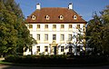
Main building of the Ullstadt palace complex
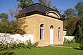
Salettl in the castle garden

Jewish Cemetery
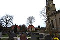
The Catholic Church of the Assumption next to the cemetery. In the background on the right the old school building.

Old farmhouses in the town center


literature
- Johann Kaspar Bundschuh : Uhlstadt . In: Geographical Statistical-Topographical Lexicon of Franconia . tape 5 : S-U . Verlag der Stettinische Buchhandlung, Ulm 1802, DNB 790364328 , OCLC 833753112 , Sp. 605-606 ( digitized version ).
- Hanns Hubert Hofmann : Neustadt-Windsheim (= Historical Atlas of Bavaria, part of Franconia . I, 2). Commission for Bavarian State History, Munich 1953, DNB 452071216 , p. 135 ( digitized version ). Ibid. S. 195 ( digitized version ).
- Gerhard Hojer: District of Scheinfeld (= Bavarian art monuments . Volume 35 ). Deutscher Kunstverlag, Munich 1976, DNB 760102457 , p. 334-357 .
- Georg Paul Hönn : Uhlstatt . In: Lexicon Topographicum of the Franconian Craises . Johann Georg Lochner, Frankfurt and Leipzig 1747, p. 301 ( digitized version ).
- Wolf Dieter Ortmann: District of Scheinfeld (= Historical Place Name Book of Bavaria, Middle Franconia . Volume 3 ). Commission for Bavarian State History, Munich 1967, DNB 457000929 , p. 204-206 .
- Gerhard Rechter: Ullstadt , in: Graf Jesko zu Dohna and Robert Schuh (eds.): In the footsteps of the princes zu Schwarzenberg , Scheinfeld 2006, pp. 54–57.
- Peter Schneider : The Steigerwald as a whole . Stürtz, Würzburg 1958, DNB 454428790 , p. 243-245 .
- Karl Ernst Stimpfig: The Jews in Sugenheim and Ullstadt: a documentation . Meyer, Scheinfeld 2001, ISBN 3-89014-167-6 .
- Pleikard Joseph Stumpf : Uhlstadt . In: Bavaria: a geographical-statistical-historical handbook of the kingdom; for the Bavarian people . Second part. Munich 1853, p. 697 ( digitized version ).
Web links
- Ullstadt in the location database of the Bayerische Landesbibliothek Online . Bavarian State Library
- Ullstadt in the Topographia Franconiae of the University of Würzburg , accessed on September 19, 2019.
- Ullstadt in the historical directory of the association for computer genealogy
- Ullstadt synagogue
Individual evidence
- ↑ a b Bavarian State Office for Statistics and Data Processing (Ed.): Official local directory for Bavaria, territorial status: May 25, 1987 . Issue 450 of the articles on Bavaria's statistics. Munich November 1991, DNB 94240937X , p. 342 ( digitized version ).
- ↑ Ullstadt in the Bavaria Atlas
- ^ Max Döllner : History of the development of the city of Neustadt an der Aisch up to 1933. Ph. C. W. Schmidt, Neustadt a. d. Aisch 1950, OCLC 42823280 ; New edition to mark the 150th anniversary of the Ph. C. W. Schmidt publishing house, Neustadt an der Aisch 1828–1978. Ibid 1978, ISBN 3-87707-013-2 , p. 99 (on the Meingozhausen monastery and its activity limited to the reason for marriage ).
- ↑ WD Ortmann, p. 206; P. Schneider, p. 243.
- ↑ Max Döllner (1950), p. 191.
- ↑ Eberhard Krauss: Exulanten im Evang.-Luth. Deanery Neustadt an der Aisch. Nuremberg 2012 (sources and research on Franconian family history, 27), passim. ISBN 978-3-929865-32-5
- ↑ HH Hofmann, p. 135.
- ↑ HH Hofmann, p. 71.
- ^ Address and statistical manual for the Rezatkreis in the Kingdom of Baiern . Buchdruckerei Chancellery, Ansbach 1820, p. 59-60 ( digitized version ). HH Hofmann p. 223.
- ↑ HH Hofmann, p. 195.
- ↑ a b c Bavarian State Statistical Office (ed.): Official city directory for Bavaria, territorial status on October 1, 1964 with statistical information from the 1961 census . Issue 260 of the articles on Bavaria's statistics. Munich 1964, DNB 453660959 , Section II, Sp. 822 ( digitized version ).
- ^ Federal Statistical Office (ed.): Historical municipality directory for the Federal Republic of Germany. Name, border and key number changes in municipalities, counties and administrative districts from May 27, 1970 to December 31, 1982 . W. Kohlhammer, Stuttgart / Mainz 1983, ISBN 3-17-003263-1 , p. 723 .
- ↑ a b Only inhabited houses are given. In 1818 these were designated as fireplaces , in 1840 as houses , and from 1871 to 1987 as residential buildings.
- ↑ a b Alphabetical index of all the localities contained in the Rezatkreise according to its constitution by the newest organization: with indication of a. the tax districts, b. Judicial Districts, c. Rent offices in which they are located, then several other statistical notes . Ansbach 1818, p. 92 ( digitized version ). For the community of Ullstadt plus the residents and buildings of Buchhof (p. 14) and Wiesenmühle (p. 103).
- ^ A b Eduard Vetter (Ed.): Statistical handbook and address book of Middle Franconia in the Kingdom of Bavaria . Self-published, Ansbach 1846, p. 63 ( digitized version ).
- ↑ a b c d e f g h i j k l m n Bavarian State Statistical Office (Hrsg.): Historical municipality register: The population of the municipalities of Bavaria from 1840 to 1952 (= contributions to Statistics Bavaria . Issue 192). Munich 1954, DNB 451478568 , p. 183 , urn : nbn: de: bvb: 12-bsb00066439-3 ( digitized version ).
- ↑ a b Joseph Heyberger, Chr. Schmitt, v. Wachter: Topographical-statistical manual of the Kingdom of Bavaria with an alphabetical local dictionary . In: K. Bayer. Statistical Bureau (Ed.): Bavaria. Regional and folklore of the Kingdom of Bavaria . tape 5 . Literary and artistic establishment of the JG Cotta'schen Buchhandlung, Munich 1867, Sp. 1084 , urn : nbn: de: bvb: 12-bsb10374496-4 ( digitized version ).
- ↑ a b Kgl. Statistical Bureau (ed.): Complete list of localities of the Kingdom of Bavaria. According to districts, administrative districts, court districts and municipalities, including parish, school and post office affiliation ... with an alphabetical general register containing the population according to the results of the census of December 1, 1875 . Adolf Ackermann, Munich 1877, 2nd section (population figures from 1871, cattle figures from 1873), Sp. 1250 , urn : nbn: de: bvb: 12-bsb00052489-4 ( digitized ).
- ↑ a b K. Bayer. Statistical Bureau (Ed.): Localities directory of the Kingdom of Bavaria. According to government districts, administrative districts, ... then with an alphabetical register of locations, including the property and the responsible administrative district for each location. LIV. Issue of the contributions to the statistics of the Kingdom of Bavaria. Munich 1888, Section III, Sp. 1184 ( digitized version ).
- ↑ a b K. Bayer. Statistical Bureau (Ed.): Directory of localities of the Kingdom of Bavaria, with alphabetical register of places . LXV. Issue of the contributions to the statistics of the Kingdom of Bavaria. Munich 1904, Section II, Sp. 1256 ( digitized version ).
- ↑ a b Bavarian State Statistical Office (ed.): Localities directory for the Free State of Bavaria according to the census of June 16, 1925 and the territorial status of January 1, 1928 . Issue 109 of the articles on Bavaria's statistics. Munich 1928, Section II, Sp. 1294 ( digitized version ).
- ↑ a b Bavarian State Statistical Office (ed.): Official place directory for Bavaria - edited on the basis of the census of September 13, 1950 . Issue 169 of the articles on Bavaria's statistics. Munich 1952, DNB 453660975 , Section II, Sp. 1121-1122 ( digitized version ).
- ↑ a b Bavarian State Statistical Office (Hrsg.): Official local directory for Bavaria . Issue 335 of the articles on Bavaria's statistics. Munich 1973, DNB 740801384 , p. 177 ( digitized version ).

Buchhof | Deutheim | Dutzenthal | Ezelheim | Hürfeld | Ingolstadt | Krassolzheim | Krautostheim | Model mill | Neundorf | Rudders | Sugenheim | Ullstadt | Meadow mill