
Hohenrechberg Castle
| Hohenrechberg Castle | ||
|---|---|---|
 The ruin seen from the southeast |
||
| Alternative name (s): | Hohen-Rechberg | |
| Creation time : | 1200 | |
| Castle type : | Höhenburg, spur location | |
| Conservation status: | ruin | |
| Standing position : | Count | |
| Construction: | Humpback cuboid | |
| Place: | Rechberg | |
| Geographical location | 48 ° 45 '21 " N , 9 ° 46' 55" E | |
| Height: | 644.2 m above sea level NHN | |
|
||

The castle Hohenrechberg , also wrote "High-Rechenberg", the ruins of a medieval Spur castle south of Schwabisch Gmund , near the district Rechenberg in Ostalbkreis in Baden-Württemberg .
Geographical location
The castle ruins are 644.2 m above sea level. NHN on the western shoulder of the Rechberg . The Rechberg is a witness mountain and belongs to the Three Kaiser Mountains . It is located on the northern edge of the Swabian Alb .
history
A Ulrich von Rechenberg was first mentioned in 1179. He was probably the builder of the castle, which was built between 1200 and 1250. It was mentioned for the first time in 1355. Hohenrechberg Castle, built as a Staufer Dienstmannenburg, was the ancestral seat of the later Counts of Rechberg . It formed the historical and administrative center of their dominion.
Between 1448 and 1450, soldiers from the imperial cities of Schwäbisch Gmünd and Schwäbisch Hall plundered the area around the castle, but did not dare to attack it. During the Peasants' War in 1525, the Hohenrechberg was spared from the pillaging farmers. However, the castle residents could not prevent the Lorch and Adelberg monasteries and the nearby Hohenstaufen Castle from being burned down. In 1546 the Schmalkaldische Bund moved up in front of the castle, but it remained intact. In contrast, Schwäbisch Gmünd was taken.
The castle was rebuilt and expanded several times. Until 1585 the rule ruled directly from their ancestral castle. Both in 1648 during the Thirty Years' War and in 1796 during the French Revolutionary Wars , the castle was occupied by the French but never destroyed. In 1865 the castle was ruined by a fire caused by lightning.
The ruin has been an outstanding sight on the Staufer road since 1977 . Until 1986 the castle was owned by the noble family. At that time it was sold to a private citizen in Göppingen.
description
The irregular, polygonal castle complex has a ring wall with humpback blocks , a Hohenstaufen palace next to the rectangular projecting gate and a 30-meter-deep castle well . The castle chapel (old chapel) has not been used since 1806 .
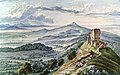
Hohenrechberg Castle, gouache by Louis Mayer , 1836 ( Hohenstaufen in the background )

Aerial view of the ruin

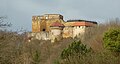
Tower and wall of the castle

Romanesque biforium and humpback cuboid on the wall of the inner kennel
The ruin seen from the east
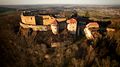
Aerial view in the evening light. Taken from the southeast.

The ruin seen from the south

The Aasrücke connects the Hohenrechberg with the Hohenstaufen (left). Taken from the south.


.jpg)


Individual evidence
- ↑ Map services of the Federal Agency for Nature Conservation ( information )
- ↑ Straße der Staufer on stauferstelen.de. Retrieved July 10, 2016.
- ^ Entry on Hohenrechberg in the private database "Alle Burgen".
literature
- Ph. L. Adam: The Kingdom of Württemberg . 1841. Gmünd, Hohenstaufen and Hohen-Rechberg as full text at Wikisource .
- Walter Ziegler: Stauferstatten im Stauferland , Walter Ziegler (Ed.), Konrad Theiss Verlag, 1977
- Günter Schmitt : Castle Guide Swabian Alb. Volume 1 · Northeast Alb. Hiking and discovering between Aalen and Aichelberg. Biberacher Verlagsdruckerei, Biberach an der Riß 1988, pp. 49-72, ISBN 3-924489-39-4
- Richard Strobel (ed.): The art monuments in Baden-Württemberg. City of Schwäbisch Gmünd, Volume IV: Churches and secular buildings outside the old town, districts . Deutscher Kunstverlag , Munich and Berlin 2003, ISBN 3-422-06381-1
Web links

Castles: Adelmannsfelden Castle | Baldern Castle | Böbingen Castle | Dambach Castle | Dorotheenhof Palace | Castle above Ellwangen | Essingen Castle | Fachsenfeld Castle | Heubach Castle | Hohenroden Castle | Hohenstadt Castle | Horn Castle | Kapfenburg Castle | Laubach Castle | Leinzell Castle | Lindach Castle | Neubronn Castle | Schechingen Castle | Tannhausen Castle | Untergröningen Castle | Utzmemmingen Castle | Wagenhofen Castle | Wasseralfingen Castle | Castle Wört | Stolch's lock
Castles and ruins: Burgstall Aalen | Alte Bürg (Riesbürg) | Burgstall Agnesburg | Burgstall Baierstein | Bargau Castle | Bettringen Castle | Degenfeld Castle | Dirgenheim Castle | Erpfental Castle | Flochberg Castle | Geislingen Castle | Granegg Castle | Gromberg Castle | Haisterhofen Castle | Herlikofen Castle | Hohenalfingen Castle | Hohenrechberg Castle | Hornsberg Castle | Itzlingen Castle | Kerkingen Castle | Killingen Castle | Kocherburg | Königsbühl Castle | Lauterburg Castle | Tower hill castle Leinroden | Merkingen Castle | Mohrenstetten Castle | Neunstadt Castle | Neresheim Castle | Niederalfingen Castle | Nordhausen Castle | Pfahlheim Castle | Burgstall Pommertsweiler | Burgstall Rechbergle | Reichenbach Castle | Röhlingen Castle | Röttingen Castle | Rosenstein Castle | Schenkenstein Castle | Burgstall Schlössle | Schönberg Castle | Schnaitberg Castle | Schwabsberg Castle | Stubenberg Castle | Unterschneidheim Castle | Waiblingen Castle | Waldau Castle | Waldhausen Castle (Aalen) | Waldhausen Castle (Lorch) | Waldstetten Castle | Weiler Castle | Burgstall Winken | Wöllstein Castle | Zipplingen Castle | Zobingen Castle