
Rosenstein Castle
| Rosenstein Castle | ||
|---|---|---|
 Rosenstein ruin |
||
| Creation time : | around 1250 | |
| Castle type : | Höhenburg, spur location | |
| Conservation status: | Wall remains, trench | |
| Standing position : | Nobles, counts | |
| Place: | Heubach | |
| Geographical location | 48 ° 47 '21.4 " N , 9 ° 56' 38.6" E | |
| Height: | 686 m above sea level NN | |
|
||


The castle Rosenstein is the ruins of a hilltop castle about 1,500 meters east of the city of Heubach in Ostalbkreis in Baden-Württemberg .
Geographical location
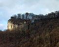
The ruin is in the spur position at around 686 meters above sea level on the Rosenstein above the Westfels. The exposed location on the edge of the Swabian Alb on a projection of the Alb eaves has always been of great strategic importance. The outer and main castle are freely accessible. The Kleine Scheuer cave is located below the complex .
history
In a document from the Kaisheim monastery from 1234, a "miles Hainricus de Hobach" is mentioned alongside other people. Presumably, these local nobles in Heubach left the town in the middle of the 13th century to build a hilltop castle on the mountain spur above the town, which was a common trend at the time. In 1282/83, a deed of donation from Count Ludwig V. von Oettingen first mentions a "Hainricus de Rosenstein" who can be assigned to the same noble family. Thus, this document is the first written mention of the castle. It has been proven that the lords of the castle were dependent on the Counts of Öttingen . In the early sources, the castle is often mentioned in connection with the neighboring Lauterburg , first documented in 1128 . In 1338, Albert Haugke, a member of the Hacken von Wöllstein - also followers of the Öttingen - appeared in the wake of the county as owner of Rosenstein Castle . By 1360 at the latest, Rosenstein Castle and Heubach, which was first designated as a town at that time, were pledged to Württemberg . After a defeat at Schorndorf in 1360 , Eberhard II of Württemberg had to cede this pledge to Emperor Charles IV . Heubach thus achieved the status of a free imperial city for a short time. In 1377, however, the Lauterburg, Rosenstein Castle and the cities of Aalen and Heubach were pledged back to Württemberg for 20,000 guilders. 1413 were the lords of Wöllwarth by Count Eberhard III. enfeoffed with Heubach, the Rosenstein and some other places in the area. In 1430 this loan relationship was converted into a pledge agreement. In 1480, Count Eberhard the Younger sold Heubach and Rosenstein for 1,800 florins to the brothers Renwarth and Jörg V. von Wöllwarth, subject to their repurchase. The heir Georg VII finally left the castle as a residence before 1524 and built an "Adenlich House" in the town, the Heubach Castle , which still exists today . The castle quickly fell into disrepair, the walls and remains of buildings served the residents of Heubach as a quarry. In the Gmünder Pürschkarte from 1572 the castle is already shown as a ruin. Only the western wall of the Palas remained to get to the present day.
At the beginning of the 19th century, against the backdrop of Romanticism, poets and linguists such as Ludwig Uhland and Gustav Schwab were drawn to the Rosenstein, while landscape painters such as August Seyffer made sketches of the ruins. With the construction of the Remsbahn in 1861, more and more day-trippers came to Heubach who also began to be interested in the Rosenstein. At the end of the eighties of the 19th century, at the instigation of the Heubach pharmacist E. Plicksburg, the beautification association was brought into being, which set itself the task of making landscape, caves and ruins accessible and maintaining them. He later went on in the Swabian Alb Association . In 1887, the Royal Württemberg Forest Administration began to restore the remains of the wall, which were threatened with collapse, and cleared the interior of rubble. In 1892 the Swabian Alb Association built a cast iron footbridge in place of the former drawbridge.
Today the castle ruins are owned by the town of Heubach. The ruin has been a sight on the Staufer road since 1997 .

Sketch of the Rosenstein ruin by A. Seyffer 1813

Key data of the history and floor plan of the castle complex
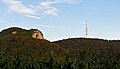
Castle ruins and television tower

Rosenstein castle ruins, in the foreground the town of Heubach

Castle rock with climbers


description
Outer bailey
The former castle area begins 100 m west of the Waldschenke restaurant in gently sloping terrain with a 15 m wide and up to 4 m deep ditch cut into the rock , which isolates the spur from the plateau at a location favored by nature. Immediately behind the moat, the terrain rises again and, together with the noise rock, forms a knoll that clearly towers above the forecourt and the castle. According to an older message, a watchtower is said to have stood on the Lärmfels, which served to warn the castle residents in good time in the event of danger. The foundations still visible at this point are the remains of a shelter built in the 19th century. In 1887, mortar remains of the wall were found on the western edge of the trench, which suggest a former fortification. Since the area in front of the main castle towers above the main castle , it can be assumed that a front castle was built at this point , in which the stables, storage buildings and accommodation necessary for the economic supply were housed in a safe location.
Main castle
.png)
The second, decisive obstacle to the approach is the 19 to 20 meters deep and 12 meters wide natural neck ditch . You enter the castle rock over the steel bridge built in 1892. The relatively limited area of the main castle meant that the development and fortification-technical execution of the main castle extended to several levels: at the top the core complex with palas and other buildings, the size, location and function of which are largely unknown. A lower-lying, also well-fortified area served not only to secure a cistern, but also offered the possibility of building additional buildings. A second entrance with a kennel , which was probably set up to supply the castle with water, was created just above the bottom of the trench .
The hall has a two-meter-thick and five-meter high western wall, over which four windows are distributed. The second from the left, which is separated by a pillar, is particularly well preserved. The reveals of the two window openings are provided with a filigree fold all around. It is possible that they were not closed with simple wooden shutters, but with lead-glazed windows, as were already common in 13th-century churches. On the outside, the west wall is covered with humpback blocks and smoothly hewn tuff stones in between. The hard-to-reach north face has even more beautiful humpback blocks.

Only in winter without foliage can you clearly see the spurs with the natural neck ditch
View from the south of the ruin, neck ditch and steel bridge
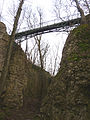
The neck ditch around 20 meters deep and the steel bridge built in 1892
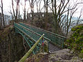
View over the steel bridge to the Palas
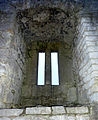
The window of the hall divided by a pillar

Outside of the west wall of the palace with humpback blocks and smoothly hewn tuff stones

The north wall of the palace with its better-preserved humpback blocks is difficult to access
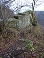
Rest of the surrounding wall of the lower castle with cistern


literature
- Günter Schmitt : Castle Guide Swabian Alb - Volume 1: Northeast Alb. Hiking and discovering between Aalen and Aichberg . Verlag Biberacher Verlagsdruckerei, Biberach 1988, ISBN 3-924489-74-2 , pp. 19-30.
- Heubach and Rosenstein Castle . Publisher: City of Heubach. Einhorn-Verlag Eduard Dietenberger GmbH 1984, ISBN 3-921703-57-3 , p. 35
- Claus Oeftiger and Eberhard Wagner: The Rosenstein near Heubach . Konrad Theiss Verlag 1985, ISBN 3-8062-0449-7 , pp. 74-89
Web links
- Reconstruction drawing by Wolfgang Braun
Individual evidence
- ↑ Straße der Staufer on stauferstelen.de. Retrieved July 10, 2016.
- ^ A b Günter Schmitt: Castle Guide Swabian Alb. Volume 1 Northeast Alb. Biberach 1988, pp. 19-30. Here: p. 25.
- ↑ Schmitt p. 27.

Castles: Adelmannsfelden Castle | Baldern Castle | Böbingen Castle | Dambach Castle | Dorotheenhof Palace | Castle above Ellwangen | Essingen Castle | Fachsenfeld Castle | Heubach Castle | Hohenroden Castle | Hohenstadt Castle | Horn Castle | Kapfenburg Castle | Laubach Castle | Leinzell Castle | Lindach Castle | Neubronn Castle | Schechingen Castle | Tannhausen Castle | Untergröningen Castle | Utzmemmingen Castle | Wagenhofen Castle | Wasseralfingen Castle | Castle Wört | Stolch's lock
Castles and ruins: Burgstall Aalen | Alte Bürg (Riesbürg) | Burgstall Agnesburg | Burgstall Baierstein | Bargau Castle | Bettringen Castle | Degenfeld Castle | Dirgenheim Castle | Erpfental Castle | Flochberg Castle | Geislingen Castle | Granegg Castle | Gromberg Castle | Haisterhofen Castle | Herlikofen Castle | Hohenalfingen Castle | Hohenrechberg Castle | Hornsberg Castle | Itzlingen Castle | Kerkingen Castle | Killingen Castle | Kocherburg | Königsbühl Castle | Lauterburg Castle | Tower hill castle Leinroden | Merkingen Castle | Mohrenstetten Castle | Neunstadt Castle | Neresheim Castle | Niederalfingen Castle | Nordhausen Castle | Pfahlheim Castle | Burgstall Pommertsweiler | Burgstall Rechbergle | Reichenbach Castle | Röhlingen Castle | Röttingen Castle | Rosenstein Castle | Schenkenstein Castle | Burgstall Schlössle | Schönberg Castle | Schnaitberg Castle | Schwabsberg Castle | Stubenberg Castle | Unterschneidheim Castle | Waiblingen Castle | Waldau Castle | Waldhausen Castle (Aalen) | Waldhausen Castle (Lorch) | Waldstetten Castle | Weiler Castle | Burgstall Winken | Wöllstein Castle | Zipplingen Castle | Zobingen Castle