
Heard
| coat of arms | Germany map | |
|---|---|---|

|
Coordinates: 49 ° 10 ' N , 8 ° 20' E |
|
| Basic data | ||
| State : | Rhineland-Palatinate | |
| County : | Germersheim | |
| Association municipality : | Rülzheim | |
| Height : | 99 m above sea level NHN | |
| Area : | 18.46 km 2 | |
| Residents: | 2596 (Dec. 31, 2019) | |
| Population density : | 141 inhabitants per km 2 | |
| Postal code : | 76771 | |
| Area code : | 07272 | |
| License plate : | GER | |
| Community key : | 07 3 34 011 | |
| Association administration address: |
At Deutschordensplatz 1 76761 Rülzheim |
|
| Website : | ||
| Local Mayor : | Max Frey ( CDU ) | |
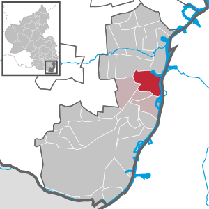
| Location of the local community Hördt in the district of Germersheim | ||
  |
||


Hördt is a municipality in the district of Germersheim in Rhineland-Palatinate . It belongs to the Verbandsgemeinde Rülzheim , within which it is the largest in terms of area and the second largest in terms of population.
geography
location
Hördt lies on and on the high bank of the Rhine between the cities of Germersheim and Wörth . The community is 100 to 121 m above sea level. NHN . The district of Hördt is 18.46 square kilometers, of which 670 hectares are state forest, 197 hectares communal forest, 919 hectares of agricultural area including paths and bodies of water and around 60 hectares of built-up area. From 1825 the Rhine near Wörth was straightened under the leadership of Tulla . In the meantime, the Hördt Rhine lowlands are seen as a potential retention area. The Oberwald is located in the southwest of the municipality marker .
Waters
The Klingbach , which flows into the Michelsbach in the east of the district, runs right through the settlement area of the municipality . The latter also includes the Rottenbach and the Altgraben . Before that, the Oberwaldgraben and Oberwaldbach flow into the Rottenbach. The Spiegelbach partly forms the northern boundary, the Rhine that in the east.
Neighboring communities
Clockwise (starting at 12 noon), Hördt has a common border with the following municipalities: Germersheim (or more precisely: Sondernheim , a district of Germersheim), Dettenheim , Linkenheim-Hochstetten , Leimersheim , Kuhardt , Rülzheim and Bellheim .
history
Early history and the Middle Ages
Archaeological finds in the corridors such as stone axes and vessels bear witness to the presence of people around 5000 BC. In the younger Stone Age . In 1937 a late Bronze Age urn grave field from around 1000 BC was opened in Hördt . Discovered.
In Roman times there was a Roman watch tower (specula) on a hill towards Bellheim, where two Roman traffic routes crossed (today's tub "Old Tower"). Further finds z. B. god stones and a bridge stone from the 2nd century suggest a Roman settlement with other buildings.
Hördt is mentioned for the first time in a document from the Fulda monastery . This document in the copy book of Rabanus Maurus confirms a donation from an Acbuto ( Agboto from Alsace) to the Fulda monastery, which included a church, several farms with 63 serfs, twelve of them between Hördt and Ottersheim (... inter Herdi et Hudamaresheim ...) . The donation was made when Baugolfus was abbot of the Fulda monastery (780–802).
The emergence of the place is dated by Ernst Christmann between the years 600 and 800. Later Hördt could have belonged to Castle Spiegelberg, which is located between Hördt and Bellheim , but it was first mentioned in 1200.
From the 12th century onwards, the development of the village was strongly influenced by the Hördt monastery, which was built in February 1103, and its provost. In 1540 the court order of the village and the Hördter village order were created.
Modern times
In the Austrian War of Succession in the 1740s, French troops ordered the construction of the Queich lines between Landau and the Rhine near Hördt as a line of fortification. A preserved ski jump can still be found today in the forest near Spiegelbach . In 1759 the French engineering corps carried out geodetic surveys and detailed mapping of the line villages . Until the end of the 18th century, the place belonged to the Electoral Palatinate and was subordinate to the Oberamt Germersheim .
From 1798 to 1814, when the Palatinate was part of the French Republic (until 1804) and then part of the Napoleonic Empire , Hördt was incorporated into the canton of Germersheim until 1814 and then into the canton of Kandel until 1815 . In 1815 the place was closed to Austria and returned to the canton of Germersheim. Just one year later, like the entire Palatinate , Hördt moved to the Kingdom of Bavaria . Then the place changed to the Kingdom of Bavaria. From 1818 to 1862 the community belonged to the Landkommissariat Germersheim ; from this the district office of Germersheim emerged.
The place survived the two world wars of the 20th century largely unscathed, but there were a total of 193 victims at the front and due to the effects of the war at home. Since 1939 the place is part of the district of Germersheim . After the Second World War , Hördt became part of the then newly formed state of Rhineland-Palatinate within the French occupation zone . In the course of the first administrative reform in Rhineland-Palatinate , Hördt was incorporated into the newly created community of Rülzheim in 1972 .
population
Population development
If not listed separately, the source of the data is the State Statistical Office of Rhineland-Palatinate.
|
|
|
religion
In 2013, 66.0 percent of the population were Catholic and 14.6 percent Protestant. The rest belonged to another religion or were non-denominational. In 1871, 1497 out of a total of 1533 inhabitants were Catholic (98 percent) and 36 Protestant (2 percent).
The St. George Church is located on the Jergenberg (= George Mountain), where once stood a nunnery. The Solemnity of the Exaltation of the Cross has been celebrated in Hördt , since a cross relic was dedicated to the parish in 1768. In the 20th century the Georgskirche was rebuilt twice, in 2001 the bell was extended by three to seven bells. In spring 2005 the inside of the church was renovated.
politics

Municipal council
The local council in Hördt consists of 20 council members, who were elected in the local elections on May 26, 2019 in a personalized proportional representation, and the honorary local mayor as chairman.
The distribution of seats in the municipal council:
| choice | SPD | CDU | FW-AB | total |
|---|---|---|---|---|
| 2019 | 3 | 9 | 8th | 20 seats |
| 2014 | 4th | 7th | 5 | 16 seats |
| 2009 | 6th | 6th | 4th | 16 seats |
| 2004 | 6th | 6th | 4th | 16 seats |
- FW-AB = Free Voters-Active Citizens Hördt e. V.
mayor
Max Frey (CDU) became local mayor of Hördt in 2014. In the direct election on May 26, 2019, he was confirmed in his office for another five years with a share of the vote of 66.20%. His predecessor Gerd Rheude (SPD) held the office for 25 years.
coat of arms
|
|
Blazon : "The Mother of God sitting on a golden throne in red, gold-nimbed, with a golden robe and blue cloak, holding a blue-covered silver church in her right hand, with her left protecting the gold-clad and -nimbated child sitting on her lap and holding a red book, at the feet a golden shield with a red mark in the form of a fallen V. " |
| Reasons for the coat of arms: The child represents Jesus. The old Hördt court seal can be seen at both feet. |
Culture and sights
Cultural monuments

Are located on site a total of 17 properties under conservation are, including the Catholic Church of St. George.
nature
There are five natural monuments within the municipality . More than two thirds of the district are nature and landscape protection areas. Regionally known is the Hördter Rheinaue , the second largest nature reserve in the Palatinate (835 ha) with rare and protected flora and fauna. The Eichtal-Brand nature reserve also partially extends over the district of Hördt.
Regular events
In 1980 the local community celebrated its 1200th anniversary with a week of festivities and has since celebrated the “ monastery festival” every five years . The gymnasium and festival hall will be available for all cultural events after the construction of the new stage. In addition, the Kerwe ( parish fair ) is held annually on the last Sunday in August.
Economy and Infrastructure
economy
Since around 1935 there has been a decline in agricultural sources of income. The cultivation of tobacco and the local "cigar makers" were and are typical of the southern Palatinate . The first cigar factory opened in 1863. The remaining full-time farmers mainly produce tobacco, asparagus and sugar beet as well as grain. Trade as well as several efficient craft businesses complement the economic strength of the village.
traffic
State road 452 runs through the middle of the municipality . State road 493 branches off from this at the southern edge of the settlement .
tourism
The PWV-Wanderheim Hördt is located on site .
Personalities

Honorary citizen
- Sr. Eusebia (born Kropp, 1917–2007), worked for 61 years in the nurses' ward of the Mallersdorfer sisters in Hördt.
- Gerd Rheude, Former Mayor (term of office 1989–2014), was honored in June 2015.
- Father Hermannjosef Mohr SSM (* 1935), long-time pastor of St. Georg Hördt, was made an honorary citizen on April 9, 2017.
Sons and daughters of the church
- Jakob Baumann (1862–1922), cathedral vicar in Speyer, writer, long-time editor of the diocese newspaper " Der Pilger "
- Friedrich Gundermann (1906 – after 1982), holder of the State Order of Merit
- Franz Hamburger (* 1946), social worker
Personalities who have worked on site
- Andreas Helmling (1959–2019), sculptor, created the “donor sculpture” in 2005 on the traffic island.
- Veronika Olma (* 1962), painter and designer, lived in Hördt from 2000 to 2005.
Picture gallery
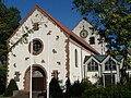
Church (2012)

School (2012)
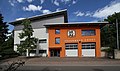
Fire station (2017)

Inscription 1777 (2017)
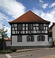
Half-timbered house in Kirchstrasse (2017)


Web links
- Website of the local community Hördt
- Website of the Rülzheim Association
- Literature about Hördt in the Rhineland-Palatinate State Bibliography
Individual evidence
- ↑ State Statistical Office of Rhineland-Palatinate - population status 2019, districts, communities, association communities ( help on this ).
- ↑ Max Frey sen., Thorsten Verlohner: Hördt's story ( memento from November 19, 2005 in the Internet Archive )
- ↑ State Statistical Office of Rhineland-Palatinate: Hördt
- ↑ a b c Official Directory and Statistics of the Royal Bavarian Government District of the Palatinate, 1863, p. XVIII of the appendix.
- ↑ a b Results of the census in the Kingdom of Bavaria from December 1, 1871 according to individual communities, 1873, p. 64.
- ↑ KommWis, as of December 31, 2013
- ^ The Regional Returning Officer Rhineland-Palatinate: Local elections 2019, city and municipal council elections
- ↑ Natascha Ruske: Before the election: Max Frey wants to build a village shop. Die Rheinpfalz, May 6, 2019, accessed on April 25, 2020 .
- ^ The Regional Returning Officer Rhineland-Palatinate: direct elections 2019. see Rülzheim, Verbandsgemeinde, first line of results. Retrieved April 25, 2020 .
- ↑ a b Hördt municipal council: Gerd Rheude becomes an honorary citizen. Pfalz-Express, March 26, 2015, accessed on April 25, 2020 .
- ↑ Appointment as an honorary citizen. Kulturgemeinde Hördt e. V., accessed on April 25, 2020 .

Bellheim | Berg (Palatinate) | Erlenbach near Kandel | Freckenfeld | Freisbach | Germersheim | Hagenbach | Hatzenbühl | Heard | Jockgrim | Candelabra | Knittelsheim | Kuhardt | Leimersheim | Lingenfeld | Lustadt | Minfeld | Neuburg am Rhein | Neupotz | Ottersheim near Landau | Rheinzabern | Rülzheim | Scheibenhardt | Schwegenheim | Steinweiler | Vollmersweiler | Weingarten (Palatinate) | Westheim (Palatinate) | Winches | Wörth am Rhein | Zeiskam