
Jeggau
|
Jeggau
City of Gardelegen
|
|
|---|---|
 |
|
| Height : | 62 m |
| Area : | 12.3 km² |
| Residents : | 184 (December 31, 2016) |
| Population density : | 15 inhabitants / km² |
| Incorporation : | January 1, 2011 |
| Postal code : | 39649 |
| Area code : | 039082 |
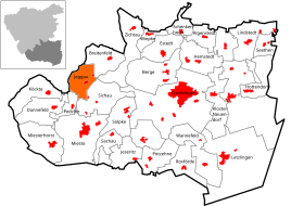  Location of the village of Jeggau in Gardelegen
|
|
Jeggau is a village and part of the Hanseatic city of Gardelegen in the Altmark district of Salzwedel in Saxony-Anhalt .
geography
Jeggau is located 13 kilometers west of Gardelegen in the southern Altmark in the Drömling nature reserve . In the southeast, the Tarnefitzer Elbe flows south into the Ohre . The Jeggauer Fleet (Flötgraben) flows north of the village to the west through the 55 hectare Jeggauer Moor nature reserve, an FFH area.
The district includes the small settlements and property and dudel that lie northeast of the street village.
traffic
The Mittelland Canal runs not far from the village, the next transshipment port is in Calvörde .
history
Jeggau was originally laid out as an anger village and later developed into a street village , as can be seen from the Urmes table sheet from 1823.
In 1429 Johannes Jeggow in Gröningen is mentioned in a document. In 1472 the place is mentioned as Jeggow , when Elector Abrecht Werner and Gebhard von Alvensleben enfeoffed the castle and the bailiwick of Gardelegen and the associated possessions. In 1472 the village belonged to the Hospital of the Holy Spirit in Gardelegen. In 1560 Jeggau was hit by a flood. In 1651 there was a fire in the village which also damaged the village church . From 1688 to 1690 the building of today's church took place as a replacement. In 1831 eight farms burned down. Since then, the village has been straightforward.
To the north of Jeggau were the villages of Hohen-Heerde and Sieden-Heerde , which had already become desolate in the 14th century .
In 1910 there were 405 inhabitants in Jeggau. At the beginning of the 20th century there was a windmill southwest of the village.
Incorporations
From January 1, 2005 to December 31, 2010, the municipality of Jeggau belonged to the administrative community Südliche Altmark and was thus one of 18 member municipalities.
On January 1, 2011, the previously independent community with the residential areas Dudel and Eigenhum was incorporated into the Hanseatic city of Gardelegen together with 17 other communities. Before the incorporation, the municipality of Jeggau had 229 inhabitants (as of December 31, 2009) and an area of 12.3 km².
Population development
|
|
|
|
Source up to 2006:
religion
The Protestant parish of Jeggau used to belong to the parish of Jeggau. Since 2003 the parish of Jeggau has belonged to the parish of Breitenfeld-Jeggau together with Breitenfeld, Köckte, Quarnebeck and Trippigleben. Today the parish belongs to the parish of Breitenfeld in the parish of Salzwedel in the Provostspengel Stendal-Magdeburg of the Evangelical Church in Central Germany .
The pastor's office was closed in 1998. Until 1998 the parish belonged to the parish of Gardelegen.
badges and flags
The coat of arms of the former municipality of Jeggau was approved by the district on September 16, 2008.
Blazon : "In gold, a blue phoenix ready to fly with a red beak and a knocked-out tongue, rising from red fire and raised by three six-pointed blue stars, the middle one larger."
The colors of Jeggau - derived from the main coat of arms and the tincture of the shield - are blue-gold (yellow).
The coat of arms was designed by the Magdeburg municipal heraldist Jörg Mantzsch .
The flag is blue-yellow (1: 1) striped (horizontal shape: stripes running horizontally, lengthways shape: stripes running vertically) and centered with the municipality's coat of arms.
Culture and sights
- The Fasslom Festival is celebrated annually in February - a custom to drive out winter and welcome spring.

- The Jeggau village church is an elongated half-timbered building from 1688 to 1690 with an organ . To the south of the church is a wooden bell carrier.
- The village cemetery is on the south of the village.
societies
- Fasslom Association Jeggau e. V.
- Gymnastics and Sports Club Jeggau 1926 e. V.
Personalities
- Karl von Jacobi (1828–1903), German ministerial official
Web links
literature
- Peter P. Rohrlach: Historical local lexicon for the Altmark (Historical local lexicon for Brandenburg, Part XII) . Berliner Wissenschafts-Verlag, Berlin 2018, ISBN 978-3-8305-2235-5 , pp. 1068-1071 .
- JAF Hermes, MJ Weigelt: Historical-geographical-statistical-topographical handbook from the administrative districts of Magdeburg . Topographical part. Ed .: Verlag Heinrichshofen. tape 2 , 1842, p. 407 , 36. Jeggau ( Textarchiv - Internet Archive ).
Individual evidence
- ↑ Saxony-Anhalt viewer of the State Office for Surveying and Geoinformation ( notes )
- ↑ World Database on Protected Areas - Jeggauer Moor (English)
- ↑ District directory of the state of Saxony-Anhalt (directory of the municipalities and parts of the municipality), territorial status January 2014. State statistical office of Saxony-Anhalt, Halle (Saale), 2016
- ↑ a b c d e Peter P. Rohrlach: Historical local lexicon for the Altmark (Historical local lexicon for Brandenburg, Part XII) . Berliner Wissenschafts-Verlag, Berlin 2018, ISBN 978-3-8305-2235-5 , pp. 1068-1071 .
- ^ Adolph Friedrich Riedel : Codex diplomaticus Brandenburgensis : Collection of documents, chronicles and other source documents . Main part 1st volume 6 . Berlin 1846, p. 118 ( digitized - no. CLVIV).
- ^ Adolph Friedrich Riedel : Codex diplomaticus Brandenburgensis : Collection of documents, chronicles and other source documents . Main part 1st volume 6 . Berlin 1846, p. 140-141 ( digitized version - no. CCI).
- ↑ Corrie Leitz in 1258-2008, 750 years Breitenfeld, commemorative , community Breitenfeld (Editor), block-Verlag Kremkau 2008, ISBN 978-3-934988-66-8 , page 83
- ^ Wilhelm Zahn: Heimatkunde der Altmark . Edited by Martin Ehlies based on the bequests of the author. 2nd Edition. Verlag Salzwedeler Wochenblatt, Graphische Anstalt, GmbH, Salzwedel 1928, p. 210 .
- ↑ Municipal directory from 1910
- ^ Map of the German Empire, 1: 100,000, Part II / IV: Sheet 264: Klötze. Prussian State Statistical Office, 1906, accessed on May 13, 2018 .
- ^ Area changes from January 1st to December 31st, 2011. StBA
- ↑ Parish Almanac or the Protestant clergy and churches of the Province of Saxony in the counties of Wernigerode, Rossla and Stolberg . 19th year, 1903, ZDB -ID 551010-7 , p. 62 ( wiki-de.genealogy.net [accessed May 13, 2018]).
- ^ Parish area Breitenfeld. Retrieved May 13, 2018 .
- ↑ Approval to use a coat of arms and a flag of the Jeggau community . In: Altmarkkreis Salzwedel (Hrsg.): Official Journal for the Altmarkkreis Salzwedel . Volume 14, No. 10/2008 . General-Anzeiger Salzwedel, Salzwedel October 22, 2008, p. 179 .
- ↑ Heischezug: Wat ist hüt and morjen - Fasslom in Jeggau . In: Volksstimme Magdeburg . February 8, 2016 ( volksstimme.de [accessed May 13, 2018]).
- ↑ Thomas Hartwig: All Altmark churches from A to Z . Elbe-Havel-Verlag, Havelberg 2012, ISBN 978-3-9814039-5-4 , p. 209 .

Ackendorf | Algenstedt | Mountains | Breitenfeld | Dannefeld | Estedt | Gardelegen | Hemstedt | Hottendorf | Ipse | Jävenitz | Jeggau | Jerchel | Jeseritz | Barge climb | Kassieck | Neuendorf Monastery | Köckte | Laatzke | Saplings | Lindenthal | Lindstedt | Lindstedterhorst | Lotsche | Lüffingen | Mieste | Miesterhorst | Parleib | Peckfitz | Polvitz | Potente | Roxförde | Sachau | Schenkenhorst | Seethen | Sichau | Siems | Solpke | Tarnefitz | Taterberg | Trüstedt | Wannefeld | Wernitz | Weteritz | Wiepke | Wollenhagen | Zichtau | Zienau | Ziepel