
Mountains (Gardelegen)
|
mountains
City of Gardelegen
Coordinates: 52 ° 33 ′ 15 ″ N , 11 ° 22 ′ 3 ″ E
|
|
|---|---|
| Height : | 45 m above sea level NHN |
| Area : | 28.12 km² |
| Residents : | 281 (December 31, 2016) |
| Population density : | 10 inhabitants / km² |
| Incorporation : | July 1, 2009 |
| Postal code : | 39638 |
| Area code : | 03907 |
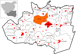  Location of the village of Berge in Gardelegen
|
|

| |
Location of mountains in Saxony-Anhalt |
Berge is a town and part of the Hanseatic city of Gardelegen in the Altmarkkreis Salzwedel in Saxony-Anhalt .
geography
The Altmark church village of Berge is located three kilometers north of the old town of Gardelegen on the B 71 leading towards the district town of Salzwedel . In the north of the T-shaped street village , the Berger Bäke flows in a north-easterly direction into the Milde .
structure
The village of Berge includes the districts of Ackendorf, Laatzke and Berge with the former living quarters Ziegelei and Mühle (Bergische Mühle) in the northeast.
history
Berge was first mentioned in 1327 as Berge prope Gardelege . Duke Otto von Braunschweig had given the monastery Königslutter income via the Hof zu Berge. The historian Rohrlach writes: “A first mention of Hermes-Weigelt for the year 1190 cannot be proven.” Further mentions of the place are: Around 1450 dat dorpp to Berge , 1460 to berge by Gardelege and 1687 Berge.
In 1412 the town was plundered by the Magdeburgers and set on fire. In 1572 a mill and a Hopfgarten with four to five Wispel hops were also mentioned. In 1745 a water mill and a grinding and fulling mill are mentioned. From before 1450 to 1810 Berge was owned by the Lords of Alvensleben for the rule of Kalbe. Since 1810, the Berge manor belonged to the master baker Bindemann in Gardelegen, who then sold the manor in sections to 27 members of the community, the manor property was lost as a result.
During the land reform in 1945, 102 properties under 100 hectares were recorded with a total of 986 hectares. One resettler received 6.1 hectares from the land reform. In 1960, 1261 hectares of usable agricultural area were named, of which the Agricultural Production Cooperative (LPG) Type III “Ernst Thälmann” in Ackendorf had 779 hectares. The two LPGs of type I “Heimaterde” and “Altmark” in Ackendorf had a total of 463 hectares, other state-owned businesses four hectares.
Incorporations
On July 1, 1950, the previously independent municipalities were Ackendorf and Laatzke from the district Gardelegen incorporated. On July 1, 1994, the municipality of Berge was reclassified from the Gardelegen district to the newly established Altmarkkreis Salzwedel.
On December 1, 2004, the community of Berge changed from the administrative community Gardelegen-Land to the administrative community Gardelegen Stadt .
On November 11, 2008, the municipality of Berge decided by means of an area change agreement that the municipality of Berge should be incorporated into the Hanseatic city of Gardelegen. This contract was approved by the county as the lower local supervisory authority and came into effect on July 1, 2009.
After the previously independent municipality of Berge was incorporated, Ackendorf, Berge and Laatzke became districts of the Hanseatic city of Gardelegen. The local constitution was introduced for the incorporated municipality in accordance with §§ 86 ff. Municipality code of Saxony-Anhalt . The incorporated municipality of Berge and future districts of Berge, Ackendorf and Laatzke became the locality of the receiving Hanseatic city of Gardelegen. A local council with nine members, including the local mayor, was formed in the incorporated municipality and now called Berge .
Population development
|
|
|
|
religion
The evangelical parish of Berge used to belong to the parish of Berge. Today the parish belongs to the parish of Estedt in the parish of Salzwedel in the Provostspengel Stendal-Magdeburg of the Evangelical Church in Central Germany . Until 1998 the parish belonged to the parish of Gardelegen.
Culture and sights
- The Protestant village church in Berge is a rectangular field stone building with a half-timbered tower in the west. The depiction of the Last Judgment with echoes of Michelangelo on the west wall above the organ earned the church the euphemistic name "The Sistine Chapel of Altmark".
- The village cemetery is in the churchyard. And proudly displays a tomb with plaques on eight notably unknown prisoners of satellite camp Hannover-sticks and the concentration camp Mittelbau-Dora , which in April 1945 during a death march from Mieste to Gardelegen of SS men were killed. The death march is related to the massacre in the Isenschnibber field barn .
literature
- Peter P. Rohrlach: Historical local lexicon for the Altmark (Historical local lexicon for Brandenburg, Part XII) . Berliner Wissenschafts-Verlag, Berlin 2018, ISBN 978-3-8305-2235-5 , pp. 183-187 .
- Wilhelm Zahn: Local history of the Altmark . Edited by Martin Ehlies based on the bequests of the author. 2nd Edition. Verlag Salzwedeler Wochenblatt, Graphische Anstalt, GmbH, Salzwedel 1928, p. 206 .
- JAF Hermes, MJ Weigelt: Historical-geographical-statistical-topographical handbook from the administrative districts of Magdeburg . Topographical part. Ed .: Verlag Heinrichshofen. tape 2 , 1842, p. 402 ( digitized version ).
Individual evidence
- ↑ Saxony-Anhalt viewer of the State Office for Surveying and Geoinformation ( notes )
- ^ Adolph Friedrich Riedel : Codex diplomaticus Brandenburgensis : Collection of documents, chronicles and other source documents . Main part 1st volume 10 . Berlin 1856, p. 120 ( digitized version ).
- ^ A b J. AF Hermes, MJ Weigelt: Historical-geographical-statistical-topographical manual from the administrative districts of Magdeburg . Topographical part. Ed .: Verlag Heinrichshofen. tape 2 , 1842, p. 402 ( digitized version ).
- ^ A b Peter P. Rohrlach: Historical Ortlexikon für die Altmark (Historical Ortlexikon für Brandenburg, Part XII) . Berliner Wissenschafts-Verlag, Berlin 2018, ISBN 978-3-8305-2235-5 , pp. 183-187 .
- ↑ Federal Statistical Office (Ed.): Municipalities 1994 and their changes since 01.01.1948 in the new federal states . Metzler-Poeschel, Stuttgart 1995, ISBN 3-8246-0321-7 , pp. 357, 361, 362 .
- ↑ Saxony-Anhalt, territorial status until June 30, 2007, administrative association changes from January 1, 1995 to June 30, 2007. Border change, Gardelegen country. July 1, 2007, accessed April 15, 2018 .
- ↑ Area change agreement incorporating the municipality of Berge into the Hanseatic city of Gardelegen . In: Altmarkkreis Salzwedel (Hrsg.): Official Journal for the Altmarkkreis Salzwedel . 15th year, no. 1 . Salzwedel January 28, 2009, p. 8–10 ( Territorial change agreement for the incorporation of the Berge community into the Hanseatic city of Gardelegen ( memento from July 26, 2015 in the Internet Archive ) [PDF; accessed April 15, 2018]). Area change agreement Incorporation of the municipality of Berge into the Hanseatic city of Gardelegen ( Memento of the original from July 26, 2015 in the Internet Archive ) Info: The archive link was automatically inserted and not yet checked. Please check the original and archive link according to the instructions and then remove this notice. (PDF; 215 kB)
- ↑ StBA: Area changes from January 2nd to December 31st, 2009
- ↑ Parish Almanac or the Protestant clergy and churches of the Province of Saxony in the counties of Wernigerode, Rossla and Stolberg . 19th year, 1903, ZDB -ID 551010-7 , p. 60 ( wiki-de.genealogy.net [accessed April 15, 2018]).
- ↑ Parish Estedt. Retrieved April 15, 2018 .
- ↑ Thomas Hartwig: All Altmark churches from A to Z . Elbe-Havel-Verlag, Havelberg 2012, ISBN 978-3-9814039-5-4 , p. 42 .

Ackendorf | Algenstedt | Mountains | Breitenfeld | Dannefeld | Estedt | Gardelegen | Hemstedt | Hottendorf | Ipse | Jävenitz | Jeggau | Jerchel | Jeseritz | Barge climb | Kassieck | Neuendorf Monastery | Köckte | Laatzke | Saplings | Lindenthal | Lindstedt | Lindstedterhorst | Lotsche | Lüffingen | Mieste | Miesterhorst | Parleib | Peckfitz | Polvitz | Potente | Roxförde | Sachau | Schenkenhorst | Seethen | Sichau | Siems | Solpke | Tarnefitz | Taterberg | Trüstedt | Wannefeld | Wernitz | Weteritz | Wiepke | Wollenhagen | Zichtau | Zienau | Ziepel