
Canton of Tinténiac
| Former Canton of Tinténiac |
|
|---|---|
| region | Brittany |
| Department | Ille-et-Vilaine |
| Arrondissement | Saint Malo |
| main place | Tinténiac |
| Establishment date | February 15, 1790 |
| Dissolution date | March 29, 2015 |
| Residents | 12,150 (Jan. 1, 2012) |
| Population density | 97 inhabitants / km² |
| surface | 125 km² |
| Communities | 10 |
| INSEE code | 3541 |
The Canton Tinténiac was a 2015 French canton in the Arrondissement Saint-Malo , in Ille-et-Vilaine and the region Bretagne ; its main town was Tinténiac .
history
The canton was established on February 15, 1790. From 1801 to 2015, ten municipalities belonged to the canton of Tinténiac (until 1801: Canton Inkniac; at times also written Canton Inkiac). With the reorganization of the cantons in France, the canton was dissolved in 2015 and the communes moved to other cantons.
location
The canton was in the northwest of the Ille-et-Vilaine department.
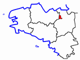
Location of the canton of Tinténiac within Brittany
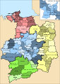
Location of the canton of Tinténiac within the Ille-et-Vilaine department
.PNG)

Communities
The canton of Tinténiac consisted of ten municipalities:
| local community | Breton | Population (2017) |
Area (km²) |
Code postal | Code Insee |
|---|---|---|---|---|---|
| La Baussaine | Baosan | 667 | 9.63 | 35190 | 35017 |
| La Chapelle-aux-Filtzméens | Chapel-Hilveven | 815 | 6.36 | 35190 | 35056 |
| Longaulnay | Hirweneg | 616 | 7.52 | 35190 | 35156 |
| Plesder | Pleder | 790 | 11.03 | 35720 | 35225 |
| Pleugueneuc | Care g | 1,903 | 24.52 | 35720 | 35226 |
| Saint-Domineuc | Landoveneg | 2,532 | 15.70 | 35190 | 35265 |
| Saint-Thual | Sant-Tual | 915 | 11.40 | 35190 | 35318 |
| Tinténiac | Ink bow | 3,635 | 23.40 | 35190 | 35337 |
| Trévérien | Treverian | 884 | 08/12 | 35190 | 35345 |
| Trimer | Tremeur | 214 | 3.56 | 35190 | 35346 |
| Canton | Ink bow | 12,150 | 125.20 | - | 3541 |
Population development
| 1962 | 1968 | 1975 | 1982 | 1990 | 1999 | 2006 | 2012 |
|---|---|---|---|---|---|---|---|
| 7,589 | 7,330 | 7.107 | 7.134 | 7.205 | 7,957 | 10,368 | 12,150 |
politics
Until its dissolution, the canton had the following members in the Council of the Départements:
| Representative in the conseil général des départements | ||
|---|---|---|
| Term of office | Surname | Political party |
| 1945–1964 | Alphonse Pellé | Wheel. |
| 1964-1988 | Roger Noguès | Rad. , Then DVD |
| 1988-1994 | Thérèse Noguès | DVD |
| 1994-2015 | André Lefeuvre | PRG |