
Saint-Thual
|
Saint-Thual Sant-Tual |
||
|---|---|---|
|
||
| region | Brittany | |
| Department | Ille-et-Vilaine | |
| Arrondissement | Saint Malo | |
| Canton | Combourg | |
| Community association | Brittany Romantique | |
| Coordinates | 48 ° 20 ′ N , 1 ° 56 ′ W | |
| height | 33-126 m | |
| surface | 11.4 km 2 | |
| Residents | 915 (January 1, 2017) | |
| Population density | 80 inhabitants / km 2 | |
| Post Code | 35190 | |
| INSEE code | 35318 | |
| Website | http://www.saint-thual.fr/ | |
_Mairie.jpg) Town hall (Mairie) of Saint-Thual |
||

Saint-Thual ( Breton : Sant-Tual ; Gallo : Saent-Tuau ) is a French commune in the Ille-et-Vilaine in the region of Brittany . The municipality has 915 inhabitants (as of January 1, 2017) and belongs to the arrondissement of Saint-Malo and the canton of Combourg (until 2015: canton Tinténiac ).
geography
Saint-Thual is about 31 kilometers north-north-west of Rennes . Saint-Thual is surrounded by the neighboring communities of Saint-Judoce and Trévérien in the north, Trimer in the east, La Baussaine in the southeast, Longaulnay in the south and Plouasne in the west.
Population development
| year | 1962 | 1968 | 1975 | 1982 | 1990 | 1999 | 2006 | 2013 |
| Residents | 533 | 468 | 423 | 376 | 391 | 412 | 612 | 825 |
| Source: Cassini and INSEE | ||||||||
Attractions
See also: List of Monuments historiques in Saint-Thual
- Sainte-Trinité Church, built between 1866 and 1874
- Old rectory
- Saint-Thual castle from the 17th century
- Tourdelin Castle from the 18th century
- Lesnen manor from the 18th century
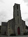
Sainte-Trinité church
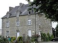
Old rectory
_%C3%89glise_01.jpg)
_Ancien_presbyt%C3%A8re.jpg)
literature
- Le Patrimoine des Communes d'Ille-et-Vilaine. Flohic Editions, Volume 2, Paris 2000, ISBN 2-84234-072-8 , pp. 1660-1663.
Web links
Commons : Saint-Thual - Collection of images, videos and audio files