
La Boussac
| La Boussac | ||
|---|---|---|
.svg)
|
|
|
| region | Brittany | |
| Department | Ille-et-Vilaine | |
| Arrondissement | Saint Malo | |
| Canton | Dol-de-Bretagne | |
| Community association | Pays de Dol et de la Baie du Mont Saint-Michel | |
| Coordinates | 48 ° 31 ′ N , 1 ° 40 ′ W | |
| height | 18-108 m | |
| surface | 21.93 km 2 | |
| Residents | 1,181 (January 1, 2017) | |
| Population density | 54 inhabitants / km 2 | |
| Post Code | 35120 | |
| INSEE code | 35034 | |
_Mairie.jpg) Town hall (Mairie) of La Boussac |
||

La Boussac ( Breton : Labouseg ; Gallo : Labóczac ) is a French commune with 1,181 inhabitants (as of January 1, 2017) in the Ille-et-Vilaine department in the northeast of the Brittany region . The municipality belongs to the arrondissement of Saint-Malo and the Dol-de-Bretagne (until 2015: Canton Pleine-Fougères ). The inhabitants are called Boussacquais .
geography
La Boussac is about 30 kilometers southeast of Saint-Malo . La Boussac is surrounded by the neighboring communities of Saint-Broladre in the north, Sains in the north-east, Pleine-Fougères in the east, Trans-la-Forêt in the south-east, Broualan in the south, Epiniac in the west and south-west and Baguer-Pican in the north-west.
Population development
| year | 1962 | 1968 | 1975 | 1982 | 1990 | 1999 | 2006 | 2017 |
| Residents | 1275 | 1152 | 964 | 937 | 909 | 973 | 1093 | 1181 |
| Sources: Cassini and INSEE | ||||||||
Attractions
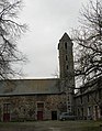
- 19th century church Saint-Pierre
- Priory of Le Brégain, Monument historique since 1926

Saint-Pierre church
Le Brégain priory
_%C3%89glise_Saint-Pierre_Ext%C3%A9rieur_03.jpg)
_Prieur%C3%A9_de_Br%C3%A9gain_01.jpg)
literature
- Le Patrimoine des Communes d'Ille-et-Vilaine. Flohic Editions, Volume 2, Paris 2000, ISBN 2-84234-072-8 , pp. 1069-1071.
Web links
Commons : La Boussac - collection of images, videos and audio files