
Epiniac
|
Epiniac Sperneg |
||
|---|---|---|
|
||
| region | Brittany | |
| Department | Ille-et-Vilaine | |
| Arrondissement | Saint Malo | |
| Canton | Dol-de-Bretagne | |
| Community association | Pays de Dol et de la Baie du Mont Saint-Michel | |
| Coordinates | 48 ° 31 ′ N , 1 ° 42 ′ W | |
| height | 11-107 m | |
| surface | 23.77 km 2 | |
| Residents | 1,426 (January 1, 2017) | |
| Population density | 60 inhabitants / km 2 | |
| Post Code | 35120 | |
| INSEE code | 35104 | |
_Mairie_01.jpg) Town Hall (Mairie) of Epiniac |
||

Epiniac ( Breton : Sperneg , Gallo : Espeinyac ) is a French municipality with 1426 inhabitants (as of January 1 2017) in the department of Ille-et-Vilaine in the region of Brittany . It belongs to the arrondissement of Saint-Malo and the canton of Dol-de-Bretagne . The inhabitants are called Épiniacais .
geography
Epiniac is about 16 kilometers southeast of Saint-Malo . Epiniac is surrounded by the neighboring communities of Baguer-Pican in the north, La Boussac in the east, Broualan in the east and south-east, Trémeheuc in the south, Bonnemain in the south-west, Baguer-Morvan in the west and Dol-de-Bretagne in the north-west.
Population development
| year | 1962 | 1968 | 1975 | 1982 | 1990 | 1999 | 2006 | 2013 |
| Residents | 1,248 | 1,126 | 1,064 | 1.104 | 1.105 | 1,078 | 1,163 | 1,401 |
| Source: Cassini and INSEE | ||||||||
Attractions
- Saint-Leonard church from the 18th century
- Saint-Pierre Church, built between 1891 and 1904
- Remains of the Notre-Dame de Vieuville monastery from the 12th century, remains since 2002 Monument historique
- Castle and domain of Les Ormes from the 16th century
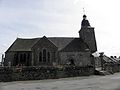
Saint-Léonard church

Saint-Pierre church
_%C3%89glise_Saint-L%C3%A9onard_2.jpg)
_%C3%89glise_01.jpg)
literature
- Le Patrimoine des Communes d'Ille-et-Vilaine. Flohic Editions, Volume 1, Paris 2000, ISBN 2-84234-072-8 , pp. 545-549.
Web links
Commons : Epiniac - collection of images, videos and audio files