
Sougéal
|
Sougéal Sulial |
||
|---|---|---|
|
||
| region | Brittany | |
| Department | Ille-et-Vilaine | |
| Arrondissement | Saint Malo | |
| Canton | Dol-de-Bretagne | |
| Community association | Pays de Dol et de la Baie du Mont Saint-Michel | |
| Coordinates | 48 ° 31 ′ N , 1 ° 31 ′ W | |
| height | 5-104 m | |
| surface | 14.15 km 2 | |
| Residents | 570 (January 1, 2017) | |
| Population density | 40 inhabitants / km 2 | |
| Post Code | 35610 | |
| INSEE code | 35329 | |
_Mairie.jpg) Town hall (Mairie) of Sougéal |
||

Sougéal ( Breton : Sulial ; Gallo : Soujhâ ) is a French commune with 570 inhabitants (as of January 1, 2017) in the Ille-et-Vilaine department in the northeast of the Brittany region . The municipality belongs to the arrondissement of Saint-Malo and the Dol-de-Bretagne (until 2015: Canton Pleine-Fougères ). The inhabitants are called Sougealais .
geography
Sougéal is about 39 kilometers southeast of Saint-Malo . Sougéal is surrounded by the neighboring communities
- Pleine-Fougères in the north and north-west,
- Pontorson in the northeast,
- Aucey-la-Plaine in the east and northeast,
- Sacey in the east,
- Val-Couesnon with Antrain in the southeast and La Fontenelle in the south,
- Vieux-Much in the west.
Population development
| year | 1962 | 1968 | 1975 | 1982 | 1990 | 1999 | 2006 | 2013 |
| Residents | 764 | 703 | 687 | 618 | 626 | 586 | 606 | 663 |
| Source: Cassini and INSEE | ||||||||
Attractions
- Menhir Roche au Diable
- Saint-Jean-Baptiste church
- Saint-Pierre Chapel

Menhir de la roche au diable (Devil's Rock)

Saint-Jean-Baptiste church
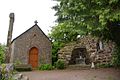
Saint-Pierre Chapel

_%C3%89glise_02.jpg)

literature
- Le Patrimoine des Communes d'Ille-et-Vilaine. Flohic Editions, Volume 2, Paris 2000, ISBN 2-84234-072-8 , pp. 1091-1093.
Web links
Commons : Sougéal - collection of images, videos and audio files