
Broualan
|
Broualan Broualan |
||
|---|---|---|

|
|
|
| region | Brittany | |
| Department | Ille-et-Vilaine | |
| Arrondissement | Saint Malo | |
| Canton | Dol-de-Bretagne | |
| Community association | Pays de Dol et de la Baie du Mont Saint-Michel | |
| Coordinates | 48 ° 31 ′ N , 1 ° 31 ′ W | |
| height | 60-116 m | |
| surface | 12.76 km 2 | |
| Residents | 373 (January 1, 2017) | |
| Population density | 29 inhabitants / km 2 | |
| Post Code | 35120 | |
| INSEE code | 35044 | |
_Mairie.jpg) Town hall (Mairie) of Broualan |
||

Broualan ( Breton : Broualan ; Gallo : Beréoalan ) is a French commune with 373 inhabitants (as of January 1, 2017) in the Ille-et-Vilaine department in the northeast of the Brittany region . The municipality belongs to the arrondissement of Saint-Malo and the Dol-de-Bretagne (until 2015: Canton Pleine-Fougères ). The inhabitants are called Broualanais .
geography
Broualan is about 33 kilometers southeast of Saint-Malo . Broualan is surrounded by the neighboring communities of La Boussac in the north, Trans-la-Forêt in the east, Cuguen in the south and Epiniac in the west and north-west.
Population development
| year | 1962 | 1968 | 1975 | 1982 | 1990 | 1999 | 2006 | 2013 |
| Residents | 445 | 372 | 299 | 268 | 279 | 290 | 297 | 386 |
| Source: Cassini and INSEE | ||||||||
Attractions
- Notre-Dame-de-Toutes-Joies church, probably built around 1483, monument historique since 1911
- Landal Castle from the 12th century, Monument historique since 1981 (see also: Pigeon Tower Château de Landal )

Notre-Dame-de-Toutes-Joies church
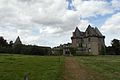
Landal Castle
_%C3%89glise_1.jpg)

literature
- Le Patrimoine des Communes d'Ille-et-Vilaine. Flohic Editions, Volume 2, Paris 2000, ISBN 2-84234-072-8 , pp. 1071-1075.
Web links
Commons : Broualan - collection of images, videos and audio files