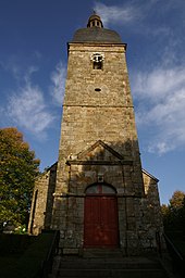
Trans-la-Forêt
|
Trans-la-Forêt Treant-Felger |
||
|---|---|---|
|
|
||
| region | Brittany | |
| Department | Ille-et-Vilaine | |
| Arrondissement | Saint Malo | |
| Canton | Dol-de-Bretagne | |
| Community association | Pays de Dol et de la Baie du Mont Saint-Michel | |
| Coordinates | 48 ° 30 ′ N , 1 ° 35 ′ W | |
| height | 33-117 m | |
| surface | 14.83 km 2 | |
| Residents | 583 (January 1, 2017) | |
| Population density | 39 inhabitants / km 2 | |
| Post Code | 35610 | |
| INSEE code | 35339 | |
 Town hall (Mairie) of Trans-la-Forêt |
||
Trans-la-Forêt ( Breton : Treant Felger ) is a French municipality with 583 inhabitants (as of January 1 2017) in the department of Ille-et-Vilaine in the region of Brittany . It belongs to the arrondissement of Saint-Malo and the canton of Dol-de-Bretagne (until 2015: canton of Pleine-Fougères ).
geography
Trans-la-Forêt is about 28 kilometers southeast of Saint-Malo . Trans-la-Forêt is surrounded by the neighboring communities of Pleine-Fougères in the north and northeast, Vieux-Viel in the east, Bazouges-la-Pérouse in the south and southeast, Cuguen in the southwest, Broualan in the west and La Bouassac in the northwest.
history
On August 1, 939, the Battle of Trans was fought here . The occupation of Brittany by the Loire-Normans , which had lasted since 919 , was thus ended by the Bretons and Franks. Alain II , known as Schiefbart , was promoted to Duke of Brittany. (However, his successor had to recognize the suzerainty of the Normans again in 952.)
Population development
| year | 1962 | 1968 | 1975 | 1982 | 1990 | 1999 | 2006 | 2013 |
| Residents | 810 | 747 | 670 | 637 | 594 | 583 | 564 | 537 |
| Source: Cassini and INSEE | ||||||||
Attractions
- Saint-Pierre church
literature
- Le Patrimoine des Communes d'Ille-et-Vilaine. Flohic Editions, Volume 2, Paris 2000, ISBN 2-84234-072-8 , pp. 1093-1095.

