
Québriac
|
Québriac Kevrieg |
||
|---|---|---|
.svg)
|
|
|
| region | Brittany | |
| Department | Ille-et-Vilaine | |
| Arrondissement | Saint Malo | |
| Canton | Combourg | |
| Community association | Brittany Romantique | |
| Coordinates | 48 ° 21 ′ N , 1 ° 50 ′ W | |
| height | 22-96 m | |
| surface | 20.72 km 2 | |
| Residents | 1,579 (January 1, 2017) | |
| Population density | 76 inhabitants / km 2 | |
| Post Code | 35440 | |
| INSEE code | 35233 | |
| Website | http://www.quebriac.fr/ | |

Québriac ( Breton : Kevrieg ; Gallo : Cóberiac ) is a French municipality with 1579 inhabitants (as of January 1 2017) in the department of Ille-et-Vilaine in the region of Brittany ; it belongs to the arrondissement of Saint-Malo and the canton of Combourg (until 2015: canton of Hédé-Bazouges ). The inhabitants are called Québriacois .
geography
Québriac is located about 28 kilometers north-northwest of Rennes on the Canal d'Ille-et-Rance . Québriac is surrounded by the neighboring communities of La Chapelle-aux-Filtzméens in the north, Combourg in the northeast, Dingé in the east, Tinténiac in the south and Saint-Domineuc in the west.
Population development
| year | 1962 | 1968 | 1975 | 1982 | 1990 | 1999 | 2006 | 2013 |
| Residents | 822 | 794 | 686 | 837 | 888 | 1,040 | 1,336 | 1,553 |
| Source: Cassini and INSEE | ||||||||
Attractions
See also: List of Monuments historiques in Québriac
- Saint-Pierre church from the 12th / 13th centuries century
- Québriac Castle, built at the end of the 19th century
- La Motte mansion
- Tremagouët hill fort

Saint-Pierre church
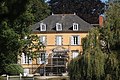
Québriac Castle


literature
- Le Patrimoine des Communes d'Ille-et-Vilaine. Flohic Editions, Volume 1, Paris 2000, ISBN 2-84234-072-8 , pp. 737-739.
Web links
Commons : Québriac - collection of images, videos and audio files