
La Chapelle-aux-Filtzméens
| La Chapelle-aux-Filtzméens | ||
|---|---|---|
|
||
| region | Brittany | |
| Department | Ille-et-Vilaine | |
| Arrondissement | Saint Malo | |
| Canton | Combourg | |
| Community association | Brittany Romantique | |
| Coordinates | 48 ° 23 ′ N , 1 ° 49 ′ W | |
| height | 21-85 m | |
| surface | 6.36 km 2 | |
| Residents | 815 (January 1, 2017) | |
| Population density | 128 inhabitants / km 2 | |
| Post Code | 35190 | |
| INSEE code | 35056 | |

La Chapelle-aux-Filtzméens (in Gallo : "La Chapèll-ez-Fius-Men", in Breton : "Chapel-Hilveven") is a municipality in Brittany in France . It belongs to the Ille-et-Vilaine department , the Saint-Malo arrondissement and the Combourg canton . The residents call themselves Capelle-Filismontin.
geography
The settlement area is on average 83 meters above sea level. In the southeast of the municipality mark resp. The Canal d'Ille-et-Rance runs in the “La Village” district . The commune is bordered by Meillac to the north, Combourg to the east, Québriac to the south, Saint-Domineuc to the west and Pleugueneuc to the northwest .
Population development
| year | 1962 | 1968 | 1975 | 1982 | 1990 | 1999 | 2008 | 2017 |
|---|---|---|---|---|---|---|---|---|
| Residents | 365 | 358 | 302 | 297 | 314 | 382 | 686 | 815 |
Attractions
- Castle, Monument historique
- Saint Joseph Church
- War memorial

Castle of La Chapelle-aux-Filtzméens
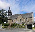
Saint Joseph Church

_%C3%89glise_01.JPG)
literature
- Le Patrimoine des Communes d'Ille-et-Vilaine. Flohic Editions, Volume 2, Paris 2000, ISBN 2-84234-072-8 , pp. 1641-1643.
Web links
Commons : La Chapelle-aux-Filtzméens - Collection of images, videos and audio files