Kerr Island
| Kerr Island (Kiss Islet) |
||
|---|---|---|
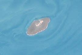
| Landsat image of the island | ||
| Waters | Arafura lake | |
| Archipelago | Torres Strait Islands | |
| Geographical location | 9 ° 36 '38 " S , 141 ° 34' 8" O | |
|
|
||
| length | 310 m | |
| width | 70 m | |
| surface | 2 ha | |
| Residents | uninhabited | |
Kerr Island (also Kerr Islet or Kiss Islet ) is a small, uninhabited island in the west of the Torres Strait Islands . It is located about 43 km south of the coast of western Papua New Guinea and 162 km northwest of the Cape York Peninsula , but still belongs to the Australian state of Queensland . The closest inhabited island is Boigu Island, 73 km northeast . The closest island ever is Deliverance Island, 7.5 km to the north .
Administratively, Kerr Island is part of the Top Western Islands , an island region in Torres Shire County .
Web links
- [1] Aerial photograph from 2002

