Sassie Island
| Sassie Island (Long Island) |
||
|---|---|---|
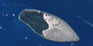
| Landsat image of Sassie Island | ||
| Waters | Pacific Ocean | |
| Geographical location | 10 ° 2 '6 " S , 142 ° 50' 53" E | |
|
|
||
| length | 5.1 km | |
| width | 2.9 km | |
| surface | 10.07 km² | |
| Highest elevation | 8 m | |
| Residents | uninhabited | |
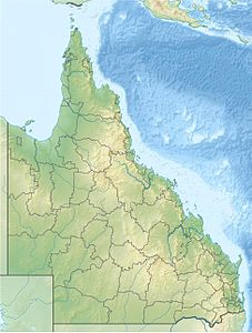
| Location of the Torres Strait Islands | ||
Sassie Island , also known as Long Island , is an island in the middle of Torres Strait , a waterway between Australia and Papua New Guinea . The 10.07 km² large island connects to the west of the 19.67 km² coral reef, Sassie Reef, which is almost twice as large .
Sassie is a coral island that rises eight meters above the surface of the water. It is the largest of the Central Islands , off Zagai . The closest inhabited island is Yam Island 14 km northwest. Also nearby are Sue Island (17 km south) and Coconut Island (21 km east). However, the closest island to Sassie Island outside of Sassie Reef is the uninhabited Bet Island 11 km south.
On the reef platform of the Sassie Reef in the east of Sassie Island there are numerous other small islands, all of which are unnamed. The smallest islands are only a few meters in diameter, while the largest island immediately (a few meters) northeast of Sassie Island covers an area of around 1.5 hectares .
See also
Individual evidence
- ↑ Royal Geographical Society: Central Strait Islands -Queensland by Degrees ( Memento of the original of March 18, 2012 in the Internet Archive ) Info: The archive link has been inserted automatically and has not yet been checked. Please check the original and archive link according to the instructions and then remove this notice.


