Yorke Islands
| Yorke Islands | |
|---|---|
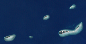
| Landsat image of the archipelago | |
| Waters | Pacific Ocean |
| archipelago | Torres Strait Islands |
| Geographical location | 9 ° 45 ′ S , 143 ° 23 ′ E |
| Number of islands | 6th |
| Main island | Yorke Island (Masig) |
| Total land area | 2.66 km² |
| Residents | 300 (2006) |
| Location of the Torres Strait Islands | |
The Yorke Islands are an Australian archipelago in the north of the Torres Strait Islands archipelago . They are about 85 km southeast of Papua New Guinea and 135 km northeast of the northern tip of Australia. The archipelago borders the Murray Islands in the east and the Bourke Islands in the south .
The Yorke Islands are small coral islands . Only the main island of Yorke is inhabited.
The group consists of six islands, of which Yorke and Kodall rest on a common reef:
| Island name | Area km² |
Geographic coordinates |
|---|---|---|
| Yorke Island (Masig) | 1.62 | 9 ° 45 ′ S , 143 ° 25 ′ E |
| Kodall Islet | 0.30 | 9 ° 44 ′ S , 143 ° 27 ′ E |
| Keats Island (Homogar) | 0.05 | 9 ° 42 ′ S , 143 ° 26 ′ E |
| Marsden Islet (Igab) | 0.21 | 9 ° 43 ′ S , 143 ° 22 ′ E |
| Rennell Island (Mawarr) | 0.46 | 9 ° 46 ′ S , 143 ° 16 ′ E |
| Smith Cay | 0.02 | 9 ° 46 ′ S , 143 ° 19 ′ E |
Administratively, the Yorke Islands are part of the Central Islands , an island region in the Torres Shire county of Queensland .

