Lake County (Colorado)
 Lake County Courthouse |
|
| administration | |
|---|---|
| US state : | Colorado |
| Administrative headquarters : | Leadville |
| Address of the administrative headquarters: |
Lake County 505 Harrison Ave. PO Box 964 Leadville, CO 80461-0964 |
| Foundation : | November 1, 1861 |
| Demographics | |
| Residents : | 7310 (2010) |
| Population density : | 7.5 inhabitants / km 2 |
| geography | |
| Total area : | 994 km² |
| Water surface : | 18 km² |
| map | |
| Website : www.ccionline.org/counties/lake.html | |
The Lake County is a county located in the western center of the US state of Colorado . In 2000 the population was 7,812. The county seat is Leadville .
geography
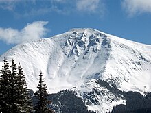
Lake County covers an area of 994 km². Of this, 1.83 percent, or 18 km², is water. The Lake County area is centrally located in the Rocky Mountains and is mainly characterized by the high, forested mountain slopes. In the west, the municipality is cut through by the continental divide of the American continent.
history
Lake County is one of Colorado's 16 original counties dating back to 1861, the number of which has grown to 64. Originally, Lake County comprised much of western Colorado south and west of the boundaries of what is now Lake County.
In the decades that followed, Lake County slowly lost territory, including Saguache Counties (1866) and Hinsdale Counties (1874) to the south, La Plata Counties (1874) and San Juan Counties (1876) to the southwest, and Ouray Counties and Gunnison to the west County (1877).
Lake County's administrative headquarters often moved within a short period of time due to its greatly reduced size. He was among others in: Oro City (1861), Lourette (1863), Dayton (1866) and Granite (1868).
In 1878 Lake County was reduced to an area that only included the present area and Chafee . On February 8, 1879, Lake County was renamed Carbonate County . This district only existed for two days, then the area was separated from Chafee County, in the south of Carbonate County, and the remaining north was renamed Lake County again. Leadville became the new administrative center.
Demographic data
| growth of population | |||
|---|---|---|---|
| Census | Residents | ± in% | |
| 1870 | 522 | - | |
| 1880 | 23,569 | 4,415.1% | |
| 1890 | 14,603 | -38% | |
| 1900 | 18,054 | 23.6% | |
| 1910 | 10,600 | -41.3% | |
| 1920 | 6630 | -37.5% | |
| 1930 | 4899 | -26.1% | |
| 1940 | 6833 | 39.5% | |
| 1950 | 8600 | 25.9% | |
| 1960 | 7101 | -17.4% | |
| 1970 | 8318 | 17.1% | |
| 1980 | 7491 | -9.9% | |
| 1990 | 6007 | -19.8% | |
| 2000 | 7102 | 18.2% | |
| 2010 | 7310 | 2.9% | |
| Before 1900
1900–1990 2000 2010 |
|||


The county had 7,812 people as of the 2000 census . There were 2977 households and 1914 families. The population density was 8 people per square kilometer. The racial the population was composed of 77.60 percent white, 0.18 percent African American, 1.25 percent Native American, 0.31 percent Asian, 0.05 percent of residents from the Pacific island area and 17.99 percent from other ethnic groups Groups; 2.62 percent were descended from two or more races. Hispanic or Latino of any race were 36.14 percent of the total population.
Of the 2,977 households, 33.9 percent had children and young people under the age of 18 living with them. 50.7 percent were married couples living together, 8.4 percent were single mothers. 35.7 percent were not families. 26.3 percent were single households and 5.6 percent had people aged 65 years or over. The average household size was 2.59 and the average family size was 3.15.
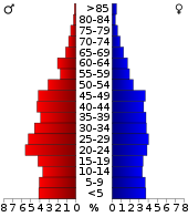
For the entire county, the population was composed of 26.9 percent of residents under 18 years of age, 12.8 percent between 18 and 24 years of age, 33.1 percent between 25 and 44 years of age, 20.6 percent between 45 and 64 years of age 6.6 percent were 65 years of age or over. The average age was 30 years. For every 100 females there were 115.8 males, and for every 100 females aged 18 and over there were 116.7 males.
The median income for a household in the county is $ 37,691 , and the median income for a family is $ 41,652. Males had a median income of $ 30,977 versus $ 24,415 for females. The per capita income was $ 18,524. 12.9 percent of the population and 9.5 percent of families are below the poverty line. This included 15.6 percent of the population under the age of 18 and 6.3 percent of the population aged 65 and over.
Places in Lake County
Passports
The Fremont Pass lies on the border with Summit County .
See also
Web links
Individual evidence
- ↑ GNIS-ID: 198149. Retrieved on February 22, 2011 (English).
- ^ US Census Bureau _ Census of Population and Housing . Retrieved February 28, 2011
- ↑ Extract from Census.gov . Retrieved February 28, 2011
- ↑ Excerpt from factfinder.census.gov.Retrieved February 28, 2011
- ^ Extract from census.gov.Retrieved March 31, 2012
Coordinates: 39 ° 11 ′ N , 106 ° 22 ′ W


