
Fort Hesselbach
| Fort Hesselbach | |
|---|---|
| limes | ORL 50 ( RLK ) |
| Route (RLK) | ORL route 10 Neckar-Odenwald-Limes Odenwald line |
| Dating (occupancy) |
Trajan until 159/161 (max. 165) |
| Type | Numerus fort |
| unit | unknown number (presumably Numerus Brittonum ) |
| size | 80 × 73 m = 0.6 ha |
| Construction | a) Wood and earth fort b) Dry stone wall c) Mortar wall |
| State of preservation | visible traces |
| place | Hesselbach |
| Geographical location | 49 ° 34 '34.5 " N , 9 ° 5' 26" E |
| height | 489 m above sea level NHN |
| Previous | ORL 49 Würzberg Fort (north) |
| Subsequently | Small fort Zwing (south) |
The Hesselbach fort was a Roman numerus fort of the older Odenwald line of the Neckar-Odenwald-Limes . Today's ground monument is located in the area of Hesselbach , a district of the town of Oberzent in the Odenwald district . The former fortification is the best-researched military camp of the Odenwald Limes and the southernmost Limes fort in Hesse . The Hesselbach fort serves as a "reference fort" for almost all other military camps in the Odenwald Limes . The knowledge gained here is used in the provincial Roman archeology to interpret the entire Limes section between the Main and Neckar.
location

The former fort Hesselbach is located on the north-eastern outskirts of Hesselbach on a non-built-up area on the eastern edge of the village that is used as meadow area, not far from today's Hessian-Bavarian border. Modern streets run in front of its praetorial front (front) and in front of the two flanks , the courtyard and pasture area of an agricultural enterprise adjoin the decumat side (rear front of the fort). The contours of the former fence stand out clearly in the terrain.
Topographically, the fort is 489 m above sea level. NHN on the plateau of a ridge that extends from the mouth of the Mümling near Obernburg to the area around Schloßau in the SSE. The plateau with its nutrient-poor red sandstone weathered soils in a relatively harsh climate did not and does not offer the best conditions for human settlement. However, the red sandstone ridge runs parallel to the Mümling at a relatively even height, which is why it was probably particularly suitable as a border line. Pre-Roman finds are missing in this area and the Roman finds also indicate a purely military, at best a very short-term civilian, post-castle use of the place.
Research history and meaning
The Hesselbach fort was mentioned briefly by Ernst Christian Hansselmann in 1768. A more detailed description was given half a century later by Johann Friedrich Knapp , who examined the Odenwald Limes on behalf of Count Franz I of Erbach-Erbach (1754–1823). The fort area was probably only examined superficially by the Hessian Limes Commission; the identification of the findings with a fort was questioned at all, since solid masonry could only be detected at one point. In 1895 the excavations of the Reichslimeskommission were carried out under the direction of the route commissioner Friedrich Kofler . The results were published in 1896.
In 1961, the Roman provincial archaeologist Dietwulf Baatz visited the Tripolitan Limes Fort Gholaia to study the structural details of the still-preserved Roman fort gate systems . Analogously, he transferred the observations he had brought up for discussion to graphic reconstructions of the gate structures at Fort Hesselbach. Baatz was then also in charge of the scientific management of the extensive investigations using the most modern methods at the time when Hesselbach was excavated by the Saalburg Museum from 1966 to 1968 . These excavations and the resulting publication were groundbreaking for further research on the Odenwald Limes. Since the excavation campaign of the 1960s, the Hesselbach fort has been considered the best-researched numerus fort of the Odenwald Limes, mainly because, in contrast to other Odenwald fort, the interior development could be comprehensively developed and documented. The interior of the other numerus fort on the Odenwald line has often been reconstructed analogous to that of the Hesselbach fort.
Findings

While the excavations of the Imperial Limes Commission at the end of the 19th century were primarily devoted to fortification (even with the field archaeological methods of that time it was not even possible to record the complex and difficult findings of the internal structures), the focus was on 1960s investigations into the exploration of the interior of the camp. With both complexes of findings, it was possible to differentiate several construction phases from one another. Since no reliable stratigraphic connection could be established between the periods of the defense and the phases of the internal structures, different names were chosen. However, based on the findings and the distribution of the finds, it is permitted to establish correlations between them.
Temporal correlations between the construction phases of the fence and the internal structures:
| Enclosure | Interior development | from | to |
| Enclosure A | Period 1 | trajanic | 115-130 |
| Fence B | Period 2 | 115-130 | at 145 |
| Enclosure C | Period 2a | at 145 | 148–161 (154–161?) |
| partially destroyed fence C | Period 3 (after the past) | 148–161 (154–161?) | no later than 165 |
Fences

The shape and scope (and thus the enclosed area) of the fortifications of the Hesselbach fort did not change or only changed in details during the various construction phases. The different walls were almost on top of each other. The entire fort area defined by the fortifications took up an area of around 6000 square meters at all times. During the entire period of its existence, the front gate (Porta praetoria) of the fortification was oriented towards the Limes, which passed the fort in just 150 meters to the east. It is noticeable that the Porta principalis dextra (right side gate) and not the Porta praetoria had the largest passage width, which suggests that this side gate took on the function of a “main gate”. The contours of the fort's fortifications can still be seen today in the largely uncultivated meadow area; the modern route runs around the outside of the fort. A display board with explanations can be found in the north of the fort.
Enclosure A
The oldest "enclosure A" was built together with the fort in Trajan times and was entirely constructed using a wood and earth construction . The wooden palisade was stabilized towards the rear, i.e. towards the interior of the camp, with an earth wall reinforced by wooden stakes, which at the same time had the function of supporting a simple battlement. In front of this wood-earth wall there was - after a narrow berm - a pointed ditch in the form of a so-called fossa Punica ("Punic ditch"). At the fossa Punica , the embankment of the ditch facing the enemy was deeper deeper than that facing the camp. In this early phase the fence had only three gates: next to the Porta praetoria there was a Porta principalis dextra (right side gate) and a Porta principalis sinistra (left side gate). The porta decumana (rear gate) was missing and could not be proven in the form of a reduced slip gate , as it is known from the last construction phase. The gates were flanked by wooden gate towers, each of which was supported by six posts. All the indications speak for the absence of corner towers, but these cannot be ruled out with absolute certainty.
Fence B
In Hadrianic times , more precisely between 115 and 130, the wooden enclosure was replaced by a double-shell drywall construction. This construction, the so-called "enclosure B", had a total width of 5.00 to 6.90 meters. The space between the outer wall shell, which is up to 1.50 meters wide, and the somewhat narrower inner wall was filled with soil interspersed with logs. The wall shells were made of uncut local red sandstone. The construction was a potentially fortified with wooden planks battlements and on the enemy side, consisting of planks or wattle parapet . The fossa Punica created in phase A continued to serve as a defensive moat, but over the years it was flooded so far that it no longer had a prominent point. The wooden gate structures were also taken over without change. The camp still had only these three gates, the slip gate on the Dekumat Front, which was discovered in the later construction phase, could not be found for this period. In the area to be assumed for this, a sewer was created instead, which disposed of a latrine built into the retentura (rear part of the storage area) directly on the fence.
Enclosure C


Between 140 and 150 AD, the dry stone wall was replaced by a mortar wall. The new defensive wall was based on the course of the old "enclosure B", in front of whose outer wall it was built. The front of the older wall is only intersected by the new construction in individual places. An earth wall was poured behind the wall, but it was not completely sloped towards the inside of the camp, but used the inner shell of the dry stone wall as a supportive boundary. The foundation of the wall was sunk 80 centimeters and had a width varying between 1.0 and 1.2 meters, the thickness of the rising was around 95 centimeters at the foot of the wall. Local red sandstone , which the builders had walled up with lime mortar, served as building material . This mortar came from not too far away shell limestone deposits in the Odenwald. The stones on the inside were small and roughly hewn, while the cuboids on the outside were larger and very carefully made. Above the parapet, the outer wall was probably covered with battlements . The possibly originally existing white external plaster, usually painted over with red dummy joints, could no longer be identified. It is probably completely eroded in the acidic soil of Hesselbach , but it can be assumed with a certain degree of certainty, analogous to other forts and watchtowers.
In the course of the new construction of the wall, the defensive trench - at least partially flooded in the meantime - was replaced by a new one. It was set off from the wall by a 60 to 80 centimeter wide berm and was about six meters wide at a depth of around 1.50 meters. It is believed that this moat was designed accordingly at a ratio of five Roman feet to 20 Roman feet.
The gates were also built from scratch. In addition to the three large gates that had previously existed, a small slip gate was added on the Dekumat side (back of the fort). The large gates were still flanked by two towers, which were probably connected not only by means of simple defensive platforms, but also by roofed gatehouses. This is supported by the fact that there were strong archways not only on the enemy side, but also on the inside. Because while such arches might be necessary on the outside for fortification reasons, they only make sense on the inside for structural reasons. The clear passage width at the Porta principalis dextra was 3.40 meters, at the other two gates, the Porta praetoria and the Porta principalis sinistra, each three meters. The new rear slip gate, which was also found in this form in the forts in Würzberg and Eulbach , is a simple gate with a clear passage of only 1.25 meters, which was possibly secured by a locking beam. The course of the trench was not interrupted in front of the gate; a post pit indicates a possible wooden walkway at this point.
There were no corner towers in this construction phase either. However, the rounded corners of the wall were provided with slightly protruding risalits on the outside . This unexplainable peculiarity of the construction of the wall can also be found in the Oberscheidental fort .
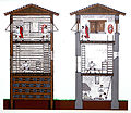
Interior development

The interior structures consisted of the central staff building ( Principia ) , four team barracks with the parlors ( Contubernia ) , the commander's apartment ( Praetorium ) as well as storage rooms and stables. The existence of the Principia makes it clear that a tactically independent unit was stationed here, a number with a crew of around 160 men. In the praetentura , the front storage area, stables and magazines were housed. As is customary in Roman military camps, the center was ruled by the Principia . In the retenture , the rear part of the camp, there was the praetorium immediately behind the principia and - flanking the principia - two crew barracks on the right and left. All buildings were made of wood, which means that they can only be identified by the discoloration of their post trenches and holes in the ground, a circumstance with which the early excavators were not sufficiently familiar, so that the excavation methods of the time could hardly be used to record findings of the interior construction.
Period 1
The Principia , the staff and administration building (also referred to as "Building 5" in publications about Hesselbach) covered an area of around 10.5 / 10.8 meters by 18.0 / 18.2 meters in this period, including the vestibule , a little less than 200 square meters in total. However, imprecise construction work and unclear and in some cases disturbed findings make it difficult to assign really exact dimensions. It is possible that the building was originally designed to be 36 by 45 Roman feet . One entered the Principia through an open vestibule measuring about 4.2 / 4.4 by 10.7 meters. This hall covered the via principalis (main warehouse street, which connected the two side warehouse gates) and opened with its front to the via praetoria (front main warehouse street ) and the porta praetoria (front warehouse gate, main gate). In addition to the Principia of Künzing Fort , the headquarters of Hesselbach is one of the oldest staff buildings with a vestibule. A courtyard , lined with two porticos at the side, was connected to the vestibule, leading to a transverse hall (basilica) . The transverse hall (and thus the entire building complex) was closed at the rear by a building consisting of three rooms. The middle, somewhat larger of these rooms was the “ flag sanctuary ” ( Aedes principiorum or Sacellum ), the other two may have served as administrative rooms .
Behind the Principia , in the middle of the Retentura (rear storage area), was the residential building of Praepositus Numeri , the commandant ( Praepositus ) of the garrison ("Building 6"). Its external dimensions were around 10.5 by 15.0 meters (a good 150 square meters); it was probably designed with dimensions of 35 by 50 Roman feet. With its entrance the commandant's building opened to the Principia . The entrance possibly led into a cross-shaped corridor, in the middle of which there could have been some kind of atrium or an atrium-like construction with a skylight. In this case, there would have been six rooms of about the same size and one smaller room (perhaps a latrine) in the building. Another interpretation of the findings suggests a long central corridor that would have been flanked by four separate rooms on each long side and the end of which could have formed a small room. A proven hearth shows that at least individual rooms in the building could be heated.
The Principia and the commandant's residence were each flanked by two team barracks ("Buildings 1 to 4"). The total of four barracks each measured about 34.6 / 34.8 by 4.55 meters (outside) and were divided into nine rooms of about the same size with about 3.70 by 4.15 meters clear width, resulting in a usable area of 15 .5 square meters per room. There was no enlarged room or a head building for the NCO. A portico could not be proven, but its existence cannot be entirely ruled out. Dietwulf Baatz assumed in his investigations that the contubernia were each occupied by four to five soldiers, so that if a room for the non-commissioned officer was deducted and the possible lower occupancy density of some rooms in which batches were housed were taken into account, a barrack occupancy of around 32 men can be assumed. This would result in a barrack occupancy with around 128 men, so that including NCOs and officers, a total of 130 to 140 men could be assumed. However, Baatz emphasized the hypothetical character of his considerations, which were only intended to give an approximate idea of the strength of the numerus fort.
In the Praetentura , the front part of the camp, a total of three larger buildings were found. The interpretation of the findings is not entirely certain due to the very strong soil erosion in this area. “Building 7” in the south-eastern area of the fort is interpreted as a storage building or warehouse, possibly including the armamentaria (armory) that are missing in the Principia . The two 4.30 by 10.60 meters and 4.30 by 13.50 meters "Buildings 8 and 9" in the north-west of the camp were most likely addressed as stables, with an oven group in front of them.
All buildings from period 1 were constructed using wood. Repairs and destruction could not be proven at any point, the buildings were apparently put down as planned before they became dilapidated in order to make space for the construction of new buildings.
Period 2
The structure of the fort in period 2 corresponded roughly to the structure of period 1. The construction technology was also largely identical, but stronger wooden posts were used than before. The buildings were in use until repairs became necessary. The phase of the repair measures that then begin is differentiated as period 2a.
The floor plan of the Principia (so-called "Building 5") was similar to that of Period 1, but the vestibule protruded laterally over the two lines of the rest of the building complex by a little more than a meter each. The hall had a width of 6.3 to 6.4 meters, a length of about 14.3 meters, was constructed in an open construction and covered the entire width of the Via Principalis . From the vestibule one got into a small, 3.8 meter wide and 7.7 meter long courtyard, which was lined on its narrow sides by 1.8 meter deep porticos. A transverse hall with a clear width of 6.9 meters and a length of 11.5 meters was connected to the courtyard. The most obvious difference to the floor plan of period 1 lies in the different proportions between the courtyard with its porticoes and the transverse hall. The space for the courtyard was reduced in favor of the space for the hall. A special feature within the transverse hall was the evidence of a cistern with a diameter of almost 1.50 meters with a channeled drain to the rear of the fort. Presumably the water was needed for cultic acts that were carried out in the Principia . The transverse hall was followed by a three-room suite of rooms, closing off the building complex at its rear, as in period 1. The middle, slightly larger room was the flag sanctuary ( Aedes or Sacellum ), which, in contrast to period 1, protruded slightly outwards on the back wall of the Principia over the flight of the building. This protrusion was reduced in the (repair) period 2a, so that the rear of the building complex again formed a uniform line. The basement, which sometimes occurs at flag sanctuaries, could not be found in Hesselbach either for the second construction phase or for the first and, moreover, appears unlikely due to the soil conditions (waterlogging).
"Building 6", the presumed home of the Praepositus Numeri , had external dimensions of around 11.7 by 10.8 meters. It was a corridor house with a central corridor, which was lined by three rooms. All six rooms were about the same size with about 15 square meters, at least four of them could be heated with stoves. The main entrance of the building faced the Principia. A second entrance on the opposite side cannot be ruled out, but this area was disturbed by a modern pit. There may have been a latrine at this end of the corridor.

As in period 1, the ensemble of principia and commandant's office was flanked by two team barracks ("Buildings 1 to 4") on each side. In contrast to the early construction phase, these had both head buildings and porticos.
"Barrack 4" was in a particularly good state of preservation. It extended with a width (with portico ) between 7.30 and 7.45 meters over a length of 34.8 meters and consisted of a series of seven contubernias with a portico in front and a head building for the centurion and / or the NCOs together. The clear width of the portico was between 1.6 and 1.7 meters. The seven contubernia accounted for 27.4 meters of the total length, each individual contubernium should have had a usable area of a little more than 19 square meters. Each contubernium consisted of a single, not further subdivided room with a hearth, which was approximately in the middle of the partition wall to a neighboring contubernium . The hearths had roughly the appearance of open chimneys that are still in use today : there was a smoke outlet behind a fireproof floor plate and a chimney above the fireplace. The hearth was used to prepare meals and as heating in the colder seasons. The head building of "Barrack 4" had an almost square floor plan with a side length of about 7.4 meters, resulting in a total living area of 53 square meters. It consisted (in continuation of the portico) of a corridor and two rooms, each of which was provided with a heating point. Two barracks (1 and 2 as well as 3 and 4) formed a pair of barracks, in the middle of which there was a path paved with gravel. The individual barracks differed from one another in a number of features in terms of shape and size:
| Barrack | length | width | Head building |
Contubernia, number |
Contubernium, greatness |
| 1 | 35.4 m | 6.45 m | 59 m² | 6th | 18.0 m² |
| 2 | 35.4 m | 7.20 m | 97 m² | 5 | 20.8 m² |
| 3 | 35.0 m | 5.25 m | no head building | 9 | 12.5 m² |
| 4th | 34.8 m | 7.37 m | 53 m² | 7th | 19.4 m² |
"Barrack 3" was significantly narrower than "Barrack 4" and had no head building, but consisted of nine roughly equal sized contubernia, each with a floor area of around 12.5 square meters. "Baracke 2" had an above-average head building with a total of three rooms and a side corridor that kinks from the main corridor. Latrines with drainage canals were found in the head structures of "Barracks 1 and 2". A corresponding latrine is also to be assumed for the head building of “Barracke 4”, but the area in question was disturbed by a modern pit, so that the corresponding archaeological evidence could not be provided.
The eastern half of the Praetentura , the front part of the camp, was completely occupied by the so-called "Building 7". It was a complex, possibly multi-phase structure with an irregular floor plan. With its external dimensions of around 20.8 by 13.1 meters, the building covered an area of around 270 square meters and had two entrances. Since the Retentura (rear part of the camp) was completely filled with the Principia , the Praetorium and the four crew barracks and the Horreum (storage building) and Armamentaria ( armamentary ) could not be located there, Dietwulf Baatz interpreted this finding as a "multi-purpose building" that had the functions of the store and the armory under one roof. According to the archaeologist, this was supported by the location of this building directly at the Porta principalis dextra, which apparently serves as the main gate (see above).
In the western part of the Praetentura , traces of the foundations of two simple buildings, which are not further subdivided inside, were found. Both buildings had an elongated rectangular shape. The to Via Praetoria "building 8", facing was 14.6 meters long and 4.0 meters wide, disposed toward the surrounding wall "building 9" had a length of 14.3 meters and a width of 5.3 meters. Analogous to the findings of period 1, the two buildings were interpreted as stables, which was also supported by the observation of water containers outside the building, as well as gutters that could have served to supply the cattle with fresh water and / or to dispose of the manure. The function of another “building 10”, a simple shed about 8.0 by 2.8 meters in size, which was located at the point where an oven group had been assumed for period 1, could not be clarified.
The camp roads consisted of a multilayered gravel with no covering by larger stones and without curbs. The form in which the warehouse was supplied with fresh water is unclear. The fact that no wells were found inside the fort does not speak against their existence per se, as the fort area was not completely excavated. Traces of water containers and gutters, however, suggest a supply of running water, possibly from an area around 250 to 300 meters northeast of the fort, where springs from the wet meadows still emerge today. This fresh water inflow, perhaps not entirely sufficient, was perhaps supplemented by rainwater collected from the roofs. The sewage disposal is better clarified. It took place via several smaller gullies that ended in a larger collecting ditch , which finally led out of the fort into a weir ditch next to the Porta decumana . At this point, not far from the Porta decumana , the latrines of the camp are to be suspected, which could have been flushed with the draining service water. However, such latrines could not be archaeologically proven, as the area of the camp that was fundamentally in question has not been excavated.
Period 2a (repair phase)
Period 2a does not denote an independent construction phase. Rather, this term encompasses all repair measures in period 2, regardless of their specific time. None of these measures led to a fundamental change in the floor plan. In some cases, individual posts, a complete post trench in the head building of Barrack 4, and the hearths were relocated in several contubernia. The most noticeable change in the Principia was the renewal of the back wall of the flag sanctuary, which after the renovation no longer protruded from the rear building line.
Period 3 (post-past time)
The findings of period 3 were already after the fort period, so the underlying former buildings were only built after the Roman troops had been moved to the line of the so-called “Vorderen Limes” in the Miltenberg - Walldürn - Osterburken area and were probably purely civil in nature. During this period, either no separate buildings were erected, or the structures consisted of light wooden structures, the traces of which could no longer be seen in the later removed and / or eroded soil. It is possible that some of the old fort buildings continued to be used, which does not seem entirely improbable, especially for "Buildings 5 and 6" and possibly for "Building 10". The excavation findings from period 3 consisted exclusively of the remains of settlement pits. In one of them the remains of a furnace were found that could be identified with certainty as a racing furnace for iron smelting. The findings made it seem certain that this furnace was only one of several, so that it can be assumed with a high degree of probability that the abandoned fort site was used by an iron-smelting company. The raw materials for iron extraction, namely iron ore and wood (coal) , could be extracted in the immediate or relative vicinity. There was no shortage of wood in the densely wooded areas of the Odenwald, even in ancient times, and iron ore could possibly be used in the form of so-called lawn iron ore . This type of iron extraction has also been proven in other places in the Odenwald for the post-Roman period. Below is a place just one kilometer north of Hesselbach. After just a few years, the smelter was stopped again, presumably for lack of profitability due to the low productivity of local ore deposits.
Found material
Coins
During the excavations in Hesselbach, only four clearly identifiable and datable coins were found, too few to be able to derive concrete and reliable statements from them. The coins in detail:
| unit | presentation | Embossing | Minting location | RIC | Location | Found year | Remarks |
| Denarius | Vitellius | 69 | Rome | 224 No. 2 (1) | Period 2 post trench | 1965 | |
| As or Dupondius | Domitian (?) | 81–96 (?) | Rome | within "building 4" | 1966 | completely corroded | |
| Denarius | Trajan | 114-117 | Rome | 337 | from a well outside the fort | 1902 | |
| Dupondius | Hadrian | 119-121 | Rome | 601 (c) | 1895 |
Sigillates
The number of sigillata shards recovered in Hesselbach was relatively high at 24% (= 224 pieces) of the total amount of ceramic finds (932 pieces) and provided important clues for dating the fort. The oldest fragments of picture bowls of southern Gallic origin could only be dated to the last decade of the 1st, but at the latest to the beginning of the 2nd century, but earlier forms of decoration were completely absent. When evaluating the ceramics, Baatz also pointed out that the Drag. 29 and drag. 15 were missing, sigillata types that usually occur in forts that were built immediately after the year 90. He interpreted this as an indication that the beginning of the camp should not be accepted until a few years after 90 at the earliest. The distribution of the sigillata types in detail:
| Type | Number of edge pieces | Periods | South Gallic (margins) |
| Drag. 18/31 (plate) | 94 | 1 to 3 | 12 (9) |
| Drag. 27 (bowl) | 47 | 1 to 3 | 5 (3) |
| Drag. 33 (bowl) | 9 | 2 to 3 | - |
| Drag. 36 (plate or shallow bowl) | 8th | 1 to 2a | 1 (1) |
| Drag. 37 (bowl) | 44 | 1 to 3 | 9 (4) |
| Others | 22nd | 1 to 3 | |
| total | 224 | 27 (17) |
|---|
Due to the relatively high proportion of South Gaulish goods in the picture bowls, Dietwulf Baatz continued to reject a time when the fort was built after 105 as extremely unlikely. The distribution of the picture bowls and pottery stamps on smooth goods was composed as follows:
| origin | Picture bowls | Pottery stamp | Remarks |
| South Gaulish goods | 9 | 0 | |
| Central Gallic goods | 8th | 1 | |
| Goods of Saturninus and Satto | 13 | 0 | |
| Goods from La Madeleine | 8th | 1 | |
| Goods from Heiligenberg (Alsace) | 4th | 2 | |
| Goods from Blickweiler | 10 | 4th | 3 different pottery names |
| Argonne ware | 0 | 1 | |
| East Gaulish goods | 0 | 3 | |
| not certain or not determinable | 0 | 5 | |
| total | 52 | 19th |
|---|
Overall, when evaluating the sigillates, Baatz came to the conclusion that the founding of Hesselbach can be dated to the late Dominian to early Trajan times, specifically to be assumed for the period between the years 95 and 105.
Other ceramics
In addition to the relatively common terra sigillata, all ceramics consisted of rough-walled goods, heavy ceramics, smooth-walled goods, varnish goods and terra nigra, of which the rough-walled goods, as is common elsewhere, made up the largest proportion. Rough-walled goods are ceramic types made fireproof through the use of strong sand . It is therefore not surprising that pots and bowls dominated among the finds of rough-walled goods (399 out of a total of 463 broken pieces). The occurrence of larger / coarser ceramics consisted exclusively of mortars (120 pieces) and amphorae (eleven pieces); there were no clay barrels (so-called dolia ). The smooth-walled goods consisted mainly of jugs and amphorae. Engobed goods and terra nigra were only represented to a small extent and both were made with different material compositions and different techniques. The distribution of the entire ceramic supply was as follows:
| genus |
Edge pieces, number |
Edge pieces, proportion |
Edge pieces, weight |
| rough-walled goods | 463 | 50% | 13,880 g |
| Terra Sigillata | 224 | 24% | 4,300 g |
| Mortars and amphorae | 131 | 14% | 13,540 g |
| smooth-walled goods | 64 | 7% | 2,685 g |
| engobed goods | 27 | 3% | 220 g |
| Terra Nigra | 23 | 2% | 960 g |
| total | 932 | 100% | 35,585 g |
|---|
Other finds
There were only a small number of metal finds and were also heavily corroded by the soil conditions in Hesselbach. There was also no reliable stratigraphic assignment, so that individual pieces could well be post-Roman. In addition to several nails, a bronze brooch , a lead washer, an iron drill and an iron awl , as well as an iron knife and an iron gate pan from the older excavations were recovered from the excavations in the 1960s . In addition to the fragment of an amethyst-colored ribbed bowl and a few fragments of other glass vessels, two fragments of window glass were particularly noticeable among the glass finds, which were also not very well represented.
There were no stamped specimens among just over 100 brick finds (nine whole bricks and around 100 fragments). Lateres (masonry tiles) dominated in terms of quantity , along with tegulae and imbrices (flat and arched roof tiles) as well as wall panels with ridge lines. However, the total number of roof tiles does not allow us to postulate a tile covering of the internal buildings of the fort or the gate towers. They can also come from the fort bath to be assumed and have been used for secondary purposes or for purposes other than intended. Such a use can also be assumed for the wall panels, which were usually only installed on stone walls that did not occur in the Hesselbacher fort. The bricks may have come from an unknown production site in the Odenwald, which is supported by the leaning with sandstone particles as they occur in the red sandstone weathered soils typical of the region.
A total of 70 sandstone balls of various sizes and weights (from less than 200 grams to 15-20 kilograms) were found during excavations in the 19th and 20th centuries in Hesselbach. Friedrich Kofler interpreted them as ballistic bullets. Dietwulf Baatz, however, came to the conclusion that, on the one hand, the gate towers of Fort Hesselbach were much too small for the installation of ballistic devices and, on the other hand, the majority of the bullets were flattened. The latter would have led to an incalculable risk for the gun crews when it was shot down. Baatz also assumed that it could possibly have been hand sling stones, but also stones that were used for weighting, as counterweights or as grinding and rubbing stones.
Naturally, there were other stone finds in the form of architectural parts, as well as some sculpture parts. The architectural fragments were dominated by cornices , wedges and the lunettes typical of the buildings of the Odenwald Limes . The most conspicuous remnant of the sculpture was the fragment of a relief made of red sandstone, of which only the depiction of a phallus 17 centimeters long and five centimeters raised with broken testicles remained. Furthermore, some fragments of hand mills were recovered.
Limes course between the Hesselbach fort and the Zwing small fort

From Fort Hesselbach, the Limes continues in a south-south-east direction on a ridge of the Odenwald, which, starting from a broad plateau, gradually tapers to a mountain ridge that is less than a hundred meters narrow. Here he enters a dense forest area on the outskirts of Hesselbach, in which he is very well preserved in places and in some places is accompanied by a medieval Landwehr. On this path it first climbs by around 55 meters in altitude and reaches near the Hessian-Baden border at around 545 meters above sea level. NN its highest point, then on the Baden side, to the small fort Zwing , dropping again by a good 50 meters. This Limes section is considered to be one of the most scenic of the entire Odenwald line.
- Reconstructions of the buildings of the Odenwald Limes

Development of construction phases 1 to 3 (older wooden tower, younger wooden tower, stone tower)

Reconstruction of a wooden tower

Reconstruction of a stone tower
Elevation of a wooden and a stone tower in comparison
.jpg)


.jpg)
| ORL | Name / place | Description / condition |
|---|---|---|
| ORL 50 | Fort Hesselbach | see above |
| Wp 10/32 | "High hump" |
Tower site with a stone tower ruin that has been severely damaged by excavation activities and a clearly visible wooden tower site. The tower point is on the ridge, a little below the summit and slightly elevated from it. The line of sight from the observation platforms of the towers ranged from Wp 10/30 in the north to Wp 10/38 in the south. Due to the elevation of the terrain, however, the platforms would have to have reached a height of at least 7.40 meters in order to get at least a little view of the ridge from there. If you had wanted to get a really clear view of the eastern Limes foothills, much greater heights would have been required. Possibly, however, the unobstructed view into Germania was of subordinate importance compared to optimal optical and acoustic connections between the individual watchtowers themselves.
The tower is one of the Limes structures that Johann Friedrich Knapp examined at the end of the 18th and beginning of the 19th century. The investigation by the Reichs-Limeskommission took place under the direction of Eduard Anthes in 1895. The stone tower had a square floor plan with a side length of 4.95 meters, the wall thickness was around one meter. In the fall layer there were fragments of a stone slab without an inscription and a stone with an inscription that could not be clearly deciphered and interpreted. The rising masonry of the tower, which was still reasonably well preserved during the investigations by the Reich Limes Commission, was almost completely removed by the residents of the village of Hesselbach in the following years. The wooden tower hill was already badly disturbed in Anthe's time. The drywall foundation could still be determined. This had a square floor plan with a side length of 6.20 meters and a wall thickness of one meter. There were four wall slots on each side to accommodate beams. From the Limes palisade, the tower was passed at a distance of 29.5 meters (east). The Erbach painter Christian Wilhelm Karl Kehrer (1770-1869), who was commissioned by Count Franz I. zu Erbach-Erbach (1754–1823) , created a watercolor from the excavation site, which was also directed by Johann Friedrich Knapp, which was not only implemented as a painting , but also appeared as an etching for the purpose of inexpensive reproduction.
|
| Wp 10/33 | "On the Bald Hump" | The tower consists of two wooden tower mounds with ring ditches and a stone tower, the foundations of which have been preserved and reconstructed. It is located on the ridge of the ridge in an exposed position, which, provided that the apron is free from trees, must have enabled a far-reaching view in all directions. The tower site had already been excavated by Knapp and was archaeologically examined again in 1888 by Friedrich Kofler and in 1889 by Wilhelm Conrady. The work of the Limes Commission under the direction of Anthes in 1895 was therefore limited to a few follow-up examinations.
The drywall foundation of the southern wooden tower had a square floor plan with a side length of 5.75 meters. The thickness of the dry masonry was only 40 to 50 centimeters. On all sides there were probably three wall slots that were used to accommodate beams. The post holes at the corners of the structure had a diameter of 30 centimeters and were sunk 1.20 meters into the ground. The foundation of the northern wooden tower also had a square floor plan. Here the sides were five meters long and the walls 90 to 95 centimeters thick. There were probably three beam slots here too. The corner posts could not be proven with certainty. Both towers were possibly originally surrounded by approximately 2.50 meter wide ring trenches, but these were not recorded more precisely. The stone tower had a square floor plan with a side length of 5.10 meters. Its wall thickness was 98 centimeters. A stone with the building inscription was found in front of the tower during the excavations. The text says: Imp (eratori) Caes (ari)
divi Hadr (iani) fil (io) T (ito) Ael (io) Hadr (iano) Antonino Aug (usto) Pio p (ontifici) m (aximo) trib (unicia) pot (estate) VIII co (n) s (uli) p (atri) p (atriae) Brit (tones) Triput (ienses) Claro II et Severo co (n) s (ulibus) Translated: “To the Emperor Caesar, the son of the deified Hadrian, Titus Aelius Hadrianus Antoninus Pius, Pontifex Maximus, holder of tribunician power for the eighth time, consul, father of the fatherland, of the Britones Triputienses. The year in which Clarus and Severus were consuls for the second time. " The inscription stone was probably built in as a window lunette. With it, the construction of the tower can be assigned to a vexillatio of the Brittones Triputienses stationed in the fort Schloßau and can be dated to the year 146 AD. A copy of the stone was placed directly next to the restored stone tower, the original is in the Baden State Museum . In addition to the discovery of inscriptions, the discovery of other architectural parts of the viewing platform was of outstanding importance. This complex of finds, which is unique in the entire Upper German-Raetian Limes, enabled a reasonably secure reconstruction of the appearance of Limes watchtowers. The distance between the Limes Palisade was 25.5 meters from the stone tower, 26.5 meters from the northern and 28.5 meters from the southern wooden tower.
|
| KK | Small fort Zwing |


_2012-09-30_082.jpg)
Monument protection

The Hesselbach fort and the adjacent Limes structures are ground monuments under the Hessian Monument Protection Act . Investigations and targeted collection of finds are subject to approval, and accidental finds are reported to the monument authorities.
See also
literature
- Dietwulf Baatz : Fort Hesselbach and other research on the Odenwald Limes. Gebr. Mann, Berlin 1973, ISBN 3-7861-1059-X (Limes research, volume 12).
- Dietwulf Baatz: The numerus fort Hesselbach (Odenwald). Short report . In: Saalburg-Jahrbuch 25, 1968, pp. 185–192.
- Dietwulf Baatz: Hesseneck-Hesselbach. In ders. And Fritz-Rudolf Herrmann (eds.): The Romans in Hessen. Licensed edition, Nikol, Hamburg 2002, ISBN 3-933203-58-9 , p. 348 f.
- Dietwulf Baatz: The Roman Limes. Archaeological excursions between the Rhine and the Danube. Gebr. Mann, Berlin 2000, ISBN 3-7861-2347-0 , pp. 192-194.
- Ernst Fabricius , Felix Hettner , Oscar von Sarwey (eds.): The Upper Germanic-Raetian Limes of the Roemerreiches , Department A, Volume 5: Route 10 (The Odenwald Limes from Wörth am Main to Wimpfen am Neckar), 1926, 1935; P. 62–68 as well as panel 7, fig. 2, panel 8, fig. 1–2, panel 16, panel 18, fig. 2.
- Holger Göldner, Fritz-Rudolf Herrmann: Sentry 10/30 “In the bird tree hedges” and Hesselbach fort on the Odenwald Limes . Office for Monument Preservation Hessen, Wiesbaden 2001, ISBN 3-89822-154-7 (Archaeological Monuments in Hessen, 154).
- Margot Klee : The Roman Limes in Hessen. History and sites of the UNESCO World Heritage. Verlag Friedrich Pustet, Regensburg 2009, ISBN 978-3-7917-2232-0 , pp. 196-199.
- Friedrich Kofler : In: The Upper Germanic-Raetian Limes of the Roemerreiches (Eds. Ernst Fabricius, Felix Hettner, Oscar von Sarwey): Department B, Volume 5, Fort No. 50 (1896).
- Egon Schallmayer : The Odenwald Limes. Along the Roman border between the Main and Neckar. Theiss, Stuttgart 2010, ISBN 978-3-8062-2309-5 , pp. 104-110.
- Egon Schallmayer: The Odenwald Limes. Latest research results. Contributions to the scientific colloquium on March 19, 2010 in Michelstadt . Saalburgmuseum, Bad Homburg 2012, ISBN 978-3-931267-07-0 (Saalburg-Schriften, 8).
Web links
- Hesselbach and the Odenwald Limes on a private website
Individual evidence
- ↑ a b c The conventional starting date of the year 100 (± 5) is based on the results of the excavations that Dietwulf Baatz carried out between 1964 and 1966. It is essentially based on the evaluation of the sigillates found (cf. the corresponding section in the article and Dietwulf Baatz: Fort Hesselbach and other research at the Odenwald Limes . Gebr. Mann, Berlin 1973, ISBN 3-7861-1059-X , (Limes research, Volume 12), pp. 85-96). In more recent literature, an initial dating of the Hesselbach fort and the entire Odenwald Limes to the period 107/110 is given preference. This dating approach is not based on new excavation findings, but on a statistical reassessment of the coin finds from all forts of the Upper Germanic-Raetian Limes, which the archaeologist Klaus Kortüm presented for the first time in 1998 and which some authors of the more recent literature now rely on. (Cf. Klaus Kortüm: On the dating of the Roman military installations in the Upper German-Raetian Limes area . In: Saalburg-Jahrbuch 49, 1998, pp. 5–65, and Egon Schallmayer : Der Limes. Geschichte einer Grenz . Beck, Munich 2006, ISBN 3 -406-48018-7 , pp. 49–52 and pp. 54–55.)
- ↑ Dietwulf Baatz: Fort Hesselbach and other research on the Odenwald Limes. Gebr. Mann, Berlin 1973, ISBN 3-7861-1059-X (Limes Research, Volume 12), pp. 9-12.
- ↑ Ernst Christian Hansselmann: Prove how far the Roman power penetrated in the wars waged with different German peoples, also in what is now East Franconia, especially Hohenlohe . Messerer, Schwäbisch Hall, 1768, p. 234.
- ^ Johann Friedrich Knapp: Roman monuments of the Odenwald, in particular of the county of Erbach and the rule of Breuberg . 1813, 2nd edition 1814, 3rd edition 1854.
- ↑ Jörg Scheuerbrandt et al .: The Romans in the area of the Neckar-Odenwald district. Frontier zone of the Roman Empire . Published by the district archive of the Neckar-Odenwald district. Verlag regionalkultur, Ubstadt-Weiher 2009, ISBN 978-3-89735-524-8 (contributions to the history of the Neckar-Odenwald district, 3), p. 12 ff.
- ^ Friedrich Kofler in the series Der Upper Germanic-Raetian Limes of the Roman Empire (eds. Ernst Fabricius, Felix Hettner, Oscar von Sarwey): Department B, Volume 5, Fort No. 50 (1896).
- ↑ Michael Mackensen : Building stock and reconstruction of the "porta praetoria" of the Severan vexillation fort Myd (---) / Gheriat el-Garbia on the "limes Tripolitanus" (Libya) . In: Christof Flügel , Jürgen Obmann (Ed.): Roman fortifications, findings and reconstruction . Volk Verlag, Munich 2013, ISBN 978-3-86222-131-8 , p. 90.
- ^ A b Dietwulf Baatz: Fort Hesselbach and other research on the Odenwald Limes. Gebr. Mann, Berlin 1973, ISBN 3-7861-1059-X (Limes research, volume 12), pp. 9–114 and panels 1–34.
- ↑ Dietwulf Baatz: Fort Hesselbach and other research on the Odenwald Limes. Gebr. Mann, Berlin 1973, ISBN 3-7861-1059-X (Limes Research, Volume 12), p. 28.
- ^ A b Dietwulf Baatz: Fort Hesselbach and other research on the Odenwald Limes. Gebr. Mann, Berlin 1973, ISBN 3-7861-1059-X (Limes Research, Volume 12), pp. 66-67.
- ↑ Dietwulf Baatz: Fort Hesselbach and other research on the Odenwald Limes. Gebr. Mann, Berlin 1973, ISBN 3-7861-1059-X (Limes Research, Volume 12), pp. 13-27.
- ^ Hyginus Gromaticus : Liber de munitionibus castrorum . Edited and explained by Alfred von Domaszewski . Hirzel, Leipzig 1887, p. 49.
- ↑ Dietwulf Baatz: Fort Hesselbach and other research on the Odenwald Limes. Gebr. Mann, Berlin 1973, ISBN 3-7861-1059-X (Limes Research, Volume 12), pp. 13-15.
- ↑ Dietwulf Baatz: Fort Hesselbach and other research on the Odenwald Limes. Gebr. Mann, Berlin 1973, ISBN 3-7861-1059-X (Limes research, volume 12), pp. 15-19 and plate 4.
- ↑ Dietwulf Baatz: Fort Hesselbach and other research on the Odenwald Limes. Gebr. Mann, Berlin 1973, ISBN 3-7861-1059-X (Limes Research, Volume 12), pp. 19-21.
- ↑ Dietwulf Baatz: Fort Hesselbach and other research on the Odenwald Limes. Gebr. Mann, Berlin 1973, ISBN 3-7861-1059-X (Limes Research, Volume 12), p. 21.
- ↑ Dietwulf Baatz: Fort Hesselbach and other research on the Odenwald Limes. Gebr. Mann, Berlin 1973, ISBN 3-7861-1059-X (Limes Research, Volume 12), pp. 21-27.
- ^ A b Dietwulf Baatz: Fort Hesselbach and other research on the Odenwald Limes. Gebr. Mann, Berlin 1973, ISBN 3-7861-1059-X (Limes Research, Volume 12), pp. 32–35.
- ↑ Dietwulf Baatz: Fort Hesselbach and other research on the Odenwald Limes. Gebr. Mann, Berlin 1973, ISBN 3-7861-1059-X (Limes Research, Volume 12), pp. 31–32.
- ↑ Dietwulf Baatz: Fort Hesselbach and other research on the Odenwald Limes. Gebr. Mann, Berlin 1973, ISBN 3-7861-1059-X (Limes Research, Volume 12), pp. 35–36.
- ↑ Dietwulf Baatz: Fort Hesselbach and other research on the Odenwald Limes. Gebr. Mann, Berlin 1973, ISBN 3-7861-1059-X (Limes Research, Volume 12), p. 37.
- ↑ Dietwulf Baatz: Fort Hesselbach and other research on the Odenwald Limes. Gebr. Mann, Berlin 1973, ISBN 3-7861-1059-X (Limes Research, Volume 12), pp. 46–50.
- ↑ Dietwulf Baatz: Fort Hesselbach and other research on the Odenwald Limes. Gebr. Mann, Berlin 1973, ISBN 3-7861-1059-X (Limes Research, Volume 12), pp. 45–46.
- ↑ Simplified according to Dietwulf Baatz: Fort Hesselbach and other research on the Odenwald Limes . Gebr. Mann, Berlin 1973, ISBN 3-7861-1059-X (Limes Research, Volume 12), p. 43.
- ↑ Dietwulf Baatz: Fort Hesselbach and other research on the Odenwald Limes. Gebr. Mann, Berlin 1973, ISBN 3-7861-1059-X (Limes Research, Volume 12), pp. 38-44.
- ↑ Dietwulf Baatz: Fort Hesselbach and other research on the Odenwald Limes. Gebr. Mann, Berlin 1973, ISBN 3-7861-1059-X (Limes Research, Volume 12), pp. 50–52.
- ↑ Dietwulf Baatz: Fort Hesselbach and other research on the Odenwald Limes. Gebr. Mann, Berlin 1973, ISBN 3-7861-1059-X (Limes Research, Volume 12), p. 52 f.
- ↑ Dietwulf Baatz: Fort Hesselbach and other research on the Odenwald Limes. Gebr. Mann, Berlin 1973, ISBN 3-7861-1059-X (Limes Research, Volume 12), p. 53 f.
- ↑ Dietwulf Baatz: Fort Hesselbach and other research on the Odenwald Limes. Gebr. Mann, Berlin 1973, ISBN 3-7861-1059-X (Limes Research, Volume 12), p. 62 f.
- ↑ Iron extraction using the Rennofen method on the website die-roemer-online.de.
- ^ K. Löhberg: Investigations on iron finds from the Hesselbach fort in the Odenwald In: Dietwulf Baatz: Hesselbach fort and other research on the Odenwald Limes. Gebr. Mann, Berlin 1973, ISBN 3-7861-1059-X (Limes Research, Volume 12), pp. 146–148.
- ^ E. Backhaus: The mineralized red sandstone samples from the Roman fort Hesselbach on the Odenwald Limes . In: Dietwulf Baatz: Fort Hesselbach and other research on the Odenwald Limes. Gebr. Mann, Berlin 1973, ISBN 3-7861-1059-X (Limes Research, Volume 12), pp. 148–152.
- ^ Eduard Anthes: Report on the work of the preservationist for the antiquities from January 1909 to the end of March 1910 . In: Grand Ducal Ministry of the Interior (ed.): Annual report on the preservation of monuments in the Grand Duchy of Hesse 1908–1911 . Darmstadt 1912, p. 62.
- ↑ Dietwulf Baatz: Fort Hesselbach and other research on the Odenwald Limes. Gebr. Mann, Berlin 1973, ISBN 3-7861-1059-X (Limes Research, Volume 12), pp. 63-66.
- ^ Helmut Schubert: The coins found in the Roman period in Germany (FMRD) Dept. V: Hessen . Vol. 2.1: Darmstadt . Mainz 1989, ISBN 3-7861-1292-4 , p. 106 f .; Dietwulf Baatz: Fort Hesselbach and other research on the Odenwald Limes. Gebr. Mann, Berlin 1973, ISBN 3-7861-1059-X (Limes Research, Volume 12), p. 84.
- ↑ Dietwulf Baatz: Fort Hesselbach and other research on the Odenwald Limes. Gebr. Mann, Berlin 1973, ISBN 3-7861-1059-X (Limes Research, Volume 12), p. 83.
- ↑ Hans-Günther Simon : Picture bowls and pottery stamps on smooth goods. In: Dietwulf Baatz: Fort Hesselbach and other research on the Odenwald Limes. Gebr. Mann, Berlin 1973, ISBN 3-7861-1059-X (Limes Research, Volume 12), p. 94.
- ↑ Dietwulf Baatz: Fort Hesselbach and other research on the Odenwald Limes. Gebr. Mann, Berlin 1973, ISBN 3-7861-1059-X (Limes research, volume 12), pp. 82–83 and 85–89 as well as Hans Günther Simon: picture bowls and potter's stamps on smooth goods. In Baatz, as above, p. 8996.
- ↑ Simplified according to Dietwulf Baatz: Fort Hesselbach and other research on the Odenwald Limes. Gebr. Mann, Berlin 1973, ISBN 3-7861-1059-X (Limes Research, Volume 12), p. 85.
- ↑ Simplified representation based on Dietwulf Baatz: Fort Hesselbach and other research on the Odenwald Limes. Gebr. Mann, Berlin 1973, ISBN 3-7861-1059-X (Limes Research, Volume 12), p. 94.
- ↑ In contrast to Baatz's investigations, more recent literature cites an initial dating of the Hesselbach fort and the entire Odenwald Limes to the period around 107/110. This dating approach is not based on new excavation findings, but on a statistical reassessment of the coin finds from all forts of the Upper Germanic-Raetian Limes, which the archaeologist Klaus Kortüm presented for the first time in 1998 and on which some authors of the more recent literature now rely. (cf. Klaus Kortüm: On the dating of the Roman military installations in the Upper Germanic-Raetian Limes area . In: Saalburg-Jahrbuch 49, 1998, pp. 5–65 and Egon Schallmayer : Der Limes. History of a border . Beck, Munich 2006, ISBN 3- 406-48018-7 , pp. 49–52 and pp. 54–55.)
- ^ After Dietwulf Baatz: Fort Hesselbach and other research on the Odenwald Limes. Gebr. Mann, Berlin 1973, ISBN 3-7861-1059-X (Limes Research, Volume 12), pp. 97-108.
- ^ After Dietwulf Baatz: Fort Hesselbach and other research on the Odenwald Limes. Gebr. Mann, Berlin 1973, ISBN 3-7861-1059-X (Limes Research, Volume 12), p. 82 f.
- ↑ Dietwulf Baatz: Fort Hesselbach and other research on the Odenwald Limes. Gebr. Mann, Berlin 1973, ISBN 3-7861-1059-X (Limes Research, Volume 12), pp. 84f.
- ↑ Dietwulf Baatz: Fort Hesselbach and other research on the Odenwald Limes. Gebr. Mann, Berlin 1973, ISBN 3-7861-1059-X (Limes Research, Volume 12), pp. 108-110.
- ↑ Dietwulf Baatz: Fort Hesselbach and other research on the Odenwald Limes. Gebr. Mann, Berlin 1973, ISBN 3-7861-1059-X (Limes Research, Volume 12), p. 112 f.
- ↑ Dietwulf Baatz: Fort Hesselbach and other research on the Odenwald Limes. Gebr. Mann, Berlin 1973, ISBN 3-7861-1059-X (Limes Research, Volume 12), pp. 110–112.
- ↑ Dietwulf Baatz: Fort Hesselbach and other research on the Odenwald Limes. Gebr. Mann, Berlin 1973, ISBN 3-7861-1059-X (Limes Research, Volume 12), p. 113.
- ↑ Baatz: The Roman Limes. Archaeological excursions between the Rhine and the Danube. Gebr. Mann, Berlin 2000, ISBN 3-7861-2347-0 , p. 193 f.
- ↑ See CIL 13, 6515
- ↑ Egon Schallmayer: The Odenwald Limes. Along the Roman border between the Main and Neckar. Theiss, Stuttgart 2010, ISBN 978-3-8062-2309-5 , p. 108.
- ↑ a b Friedrich Kofler, in: Westdeutsche Zeitschrift für Geschichte und Kunst , 8/1888, p. 59.
- ^ Wilhelm Conrady at Georg Schäfer: The art monuments in the Grand Duchy of Hesse, Erbach district . Bergsträßer, Darmstadt 1891, p. 131 f.
- ↑ CIL 13, 6514 .
- ↑ Jörg Scheuerbrandt et al .: The Romans in the area of the Neckar-Odenwald district. Frontier zone of the Roman Empire . Published by the district archive of the Neckar-Odenwald district. regional culture publishing house, Ubstadt-Weiher 2009, ISBN 978-3-89735-524-8 (contributions to the history of the Neckar-Odenwald district, 3), p. 13 f. and 44.
- ↑ Egon Schallmayer: The Odenwald Limes. Along the Roman border between the Main and Neckar. Theiss, Stuttgart 2010, ISBN 978-3-8062-2309-5 , pp. 108-110.
Remarks
- ↑ Even before the establishment of the Imperial Limes Commission (RLK), efforts had been made at the state level to collectively record the Roman relics in the respective territories. In 1877, for example, in the Kingdom of Württemberg and in 1880 in the Grand Duchy of Hesse and the Grand Duchy of Baden, state Limes Commissions were established, which were able to successfully demonstrate the course of the Limes in several places.
- ↑ On the northeast side.
- ↑ On the southwest side.
- ↑ Dietwulf Baatz suspected that the low number of finds could possibly be due to the fact that the camp had never been destroyed during the entire period of its existence and was finally cleared peacefully. Objects of value would usually be found in large numbers in horizons of destruction or in depots . The former did not exist in Hesselbach, the evacuation of the fort took place under peaceful circumstances, and there was apparently no need for the formation of depots to protect against enemy attacks (Dietwulf Baatz: Kastell Hesselbach and other research on the Odenwald Limes. Gebr. Mann, Berlin 1973 , ISBN 3-7861-1059-X (Limes Research, Volume 12), p. 82 f.)
- ↑ The 24 %% (224 pieces) Sigillata stand opposite: 50% (463 pieces) rough-walled goods, 14% (131 pieces) heavy ceramics, 7% (64 pieces) smooth-walled goods, 3% (27 pieces) engobed goods and 2% (23 St.) Terra Nigra .
- ↑ a b typology of Terra Sigillata according to Hans Dragendorff , especially in the Terra Sigillata writings . A contribution to the history of Greek and Roman ceramics . In: Bonner Jahrbücher 96/97, 1895, pp. 18–155 and a list of the stamps on terra sigillata vessels, which can be dated to around 70–250 AD . In: Bonner Jahrbücher 99, 1896, pp. 54–163.
- ↑ Drag type . 29 ( Memento from August 1, 2010 in the Internet Archive )
- ↑ Drag type . 15/17 ( Memento from August 1, 2010 in the Internet Archive )
- ↑ See also list of important terra sigillata vessel shapes .
- ↑ Type 18/31 ( Memento from August 1, 2010 in the Internet Archive )
- ↑ Drag type . 27 ( Memento from August 1, 2010 in the Internet Archive )
- ↑ Drag type . 33 ( Memento from August 1, 2010 in the Internet Archive )
- ↑ Drag type . 36 ( Memento from August 1, 2010 in the Internet Archive )
- ↑ Drag type . 37 ( Memento from August 1, 2010 in the Internet Archive )
- ↑ ORL = numbering of the Limes structures according to the publication of the Reich Limes Commission on the O bergermanisch- R ätischen- L imes
- ↑ Wp = W oh p east, watch tower. The number before the slash denotes the Limes section, the number after the slash denotes the respective watchtower.
- ↑ At about 49 ° 34 '12 " N , 9 ° 5' 54.25" O .
- ↑ At about 49 ° 33 '50.75 " N , 9 ° 5' 58" O .
- ↑ Wp 10/33 th on the private Limes project page of Claus Vehne.
- ↑ Conrady had spoken of only two slits in his excavation report, but a photographic image showed a third slit on the west side of the building.
- ↑ Anthes postulated only two slots, but according to Conrady there were probably originally three on all sides, one of which was bricked up in the course of later repair work.
- ↑ According to Adam Hammeran, who visited the tower in 1889/90, it was 5.60 meters.
- ↑ According to Adam Hammeran, it was 92 centimeters.
- ↑ KK = unnumbered K linseed K astell
- ↑ 49 ° 33 ′ 40 ″ N , 9 ° 6 ′ 4 ″ E