
List of beacons on the Lower Elbe
The list of beacons on the lower Elbe has lighthouses , leading lights , pier light and cross light along by the tide influenced the course of the Elbe between Cuxhaven and the barrage Geesthacht .
| Surname | place | position | Construction year | Tower height | Fire height | Function (s) / remarks | image |
|---|---|---|---|---|---|---|---|
| Kugelbake | Cuxhaven | 53 ° 53 '30.6 " N , 8 ° 41' 13.8" E | 1703 | 28 m | - | 1853–1878 also a beacon |

|
| Hamburg lighthouse | Cuxhaven | 53 ° 52 '19.2 " N , 8 ° 42' 30.1" E | 1805 | 23 m | 24 m | Deleted in 2001 |

|
| Unterfeuer Baumrönne | Cuxhaven | 53 ° 51 '12 " N , 8 ° 44' 8.9" E | 1971 | 25 m | 24 m | Erased in 2010 and demolished in 2011 |
.jpg)
|
| Fat Berta | Altenbruch | 53 ° 50 '8.9 " N , 8 ° 46' 16.9" E | 1897 | 14 m | 10 m | 1983 deleted, monument |

|
| Altenbruch overhead fire | Altenbruch | 53 ° 49 '48.3 " N , 8 ° 45' 26.7" E | 1970 | 59 m | 51 m | Leading light from kilometers 706 to 715 |

|
| Altenbruch fire | Altenbruch | 53 ° 50 ′ 1 " N , 8 ° 47 ′ 41.2" E | 1972 | 20 m | 19 m | Leading lights from km 706 to 715 (with Altenbruch fire) and from km 721 to 726 (with Wehldorf fire) |

|
| Oberfeuer Wehldorf | Altenbruch | 53 ° 49 '48 .3 " N , 8 ° 48' 6.2" E | 1972 | 29 m | 31 m | Leading light from km 721 to 726 (with Altenbruch lower light) |

|
| Oberfeuer Otterndorf | Otterndorf | 53 ° 49 '33.6 " N , 8 ° 54' 4.1" E | 1986 | 52 m | 52 m | Leading light from km 700 to 706 (with Belum lower light) |

|
| Belum sub-fire | Belum | 53 ° 50 '7.3 " N , 8 ° 56" 8.7 " E | 1986 | 25 m | 23 m | Leading lights from km 700 to 706 (with Otterndorf headlight) and from km 717 to 720 (with Belum headlight) | |
| Overfire Belum | Belum | 53 ° 50 ′ 5.1 " N , 8 ° 57 ′ 21" E | 1986 | 44 m | 45 m | Leading light from kilometers 717 to 720 |

|
| Oberfeuer Osteriff | Balje | 53 ° 51 ′ 0 ″ N , 9 ° 0 ′ 27 ″ E | 1936 | 25 m | 25 m | Erased in 1980 and demolished in 1983 | |
| Osteriff sub-fire | Balje | 53 ° 51 '17 " N , 9 ° 1' 18" E | 1929 | 14 m | 11 m | Erased in 1980 and demolished in 1983 | |
| Subfire Balje | Balje | 53 ° 51 '17.7 " N , 9 ° 2' 37.3" E | 1980 | 24 m | 24 m | Leading light from kilometers 716 to 703 |

|
| Headfire Balje | Balje | 53 ° 51 '29.9 " N , 9 ° 4' 50.3" E | 1977 | 56 m | 54 m | Leading light from kilometers 716 to 703 |

|
| Balje lighthouse | Balje | 53 ° 51 '34.7 " N , 9 ° 4' 49.3" E | 1904 | 17 m | 15 m | Replaced in 1980 by the Balje leading light line, monument |

|
| Brunsbüttel pier 4 | Brunsbuettel | 53 ° 53 '14.8 " N , 9 ° 7' 34.8" E | 1992 | 13 m | 13 m | Molenfeuer new lock chamber |
.jpg)
|
| Brunsbüttel pier 3 | Brunsbuettel | 53 ° 53 '15.3 " N , 9 ° 8' 5.6" E | 1992 | 14 m | 13 m | Molenfeuer new lock chamber |
.jpg)
|
| Brunsbüttel pier 2 | Brunsbuettel | 53 ° 53 '15.2 " N , 9 ° 8' 16.9" E | 2012 | 10 m | 14 m | Molenfeuer old lock chamber |

|
| Brunsbüttel pier 2 | Brunsbuettel | 53 ° 53 '15.3 " N , 9 ° 8' 17.3" E | 1895 | 13 m | 14 m | Replaced in 2012, cultural monument |
.jpg)
|
| Brunsbüttel pier 1 | Brunsbuettel | 53 ° 53 '16.3 " N , 9 ° 8' 34.2" E | 1895 | 11 m | 14 m | Molenfeuer old lock chamber, cultural monument |

|
| Subfire Brunsbüttel | Brunsbuettel | 53 ° 53 ′ 19.4 " N , 9 ° 8 ′ 28" E | 1975 | 23 m | 24 m | Leading light from kilometers 706 to 700 |
.jpg)
|
| Headfire Brunsbüttel | Brunsbuettel | 53 ° 53 '41.2 " N , 9 ° 9' 49" E | 1975 | 49 m | 46 m | Leading light from kilometers 706 to 700 |

|
| Upper fire Sankt Margarethen | Saint Margarethen | 53 ° 53 ′ 14 " N , 9 ° 14 ′ 55.6" E | 1983 | 37 m | 37 m | Leading light from kilometers 681 to 686 (with Scheelenkuhlen lower light) |

|
| Scheelenkuhlen underfire | Saint Margarethen | 53 ° 52 ′ 51 " N , 9 ° 15 ′ 39.6" E | 1975 | 23 m | 20 m | Leading lights from kilometers 681 to 686 (with Sankt Margarethen upper fire) and from kilometers 692 to 697 (with Scheelenkuhlen upper fire) |
.JPG)
|
| Oberfeuer Scheelenkuhlen | Saint Margarethen | 53 ° 52 ′ 51.8 " N , 9 ° 17 ′ 20" E | 1976 | 47 m | 44 m | Leading lights from kilometers 692 to 697 | |
| Subfire end of Easter | Brokdorf | 53 ° 51 '0.1 " N , 9 ° 20' 26.1" E | 1984 | 19 m | 22 m | Leading lights from 686 to 690 kilometers |

|
| Oberfeuer Easter end | Wewelsfleth | 53 ° 50 ′ 45.5 " N , 9 ° 21 ′ 17" E | 1983 | 38 m | 36 m | Leading lights from 686 to 690 kilometers |

|
| Brokdorf Head Fire | Brokdorf nuclear power plant | 53 ° 51 '9.3 " N , 9 ° 20' 47.3" E | 1982 | 46 m | 44 m | Leading light from kilometers 672 to 679 (with lower light Hollerwetter) |
.jpg)
|
| Hollerwetter lighthouse | Wewelsfleth | 53 ° 50 '27.5 " N , 9 ° 21' 10.1" E | 1911 | 18 m | 15 m | Replaced in 1982 by the Hollerwetter sub-fire, monument |

|
| Unterfeuer Hollerwetter | Wewelsfleth | 53 ° 50 ′ 21.8 " N , 9 ° 21 ′ 15.9" E | 1982 | 22 m | 21 m | Leading light from kilometers 672 to 679 (with Brokdorf upper light) |

|
| Subfire sturgeon | Borsfleth | 53 ° 49 ′ 15 " N , 9 ° 23 ′ 50" E | 1903 | 8 m | 8 m | Leading light of the estuary |

|
| Upper fire sturgeon | Borsfleth | 53 ° 49 ′ 14 " N , 9 ° 24 ′ 0" E | 1984 | 12 m | 13 m | Leading light of the estuary |

|
| Beacon North Rhinplate | Rhinplate | 53 ° 48 '1.4 " N , 9 ° 23' 17.8" E | 1954 | 14 m | 12 m | Beacon from kilometers 681 to 679 |

|
| Glückstadt sub-fire | Glückstadt | 53 ° 48 '18.4 " N , 9 ° 24' 15.2" E | 1937/2018 | 21 m | 20 m | Leading light from kilometers 686 to 681 |

|
| Oberfeuer Glückstadt | Glückstadt | 53 ° 47 '51.1 " N , 9 ° 25' 6.7" E | 1937/2018 | 42 m | 40 m | Leading light from kilometers 686 to 681 |

|
| Beacon in the Wischhafener Süderelbe | Wischhafen | 53 ° 47 '16.5 " N , 9 ° 21' 11.9" E | 1932 | 6 m | 7 m | Beacon of the Wischhafener Süderelbe | |
| Beacon in Glückstadt | Glückstadt | 53 ° 47 ′ 6.1 " N , 9 ° 24 ′ 31.1" E | 1995 | 9 m | 9 m | Beacon of the Glückstadt side Elbe |
.jpg)
|
| Cabbage sand under fire | Drochtersen | 53 ° 45 ′ 15.9 " N , 9 ° 23 ′ 11" E | 1978 | 20 m | 20 m | Leading light from kilometers 668 to 670 |
.jpg)
|
| Krautsand top fire | Drochtersen | 53 ° 45 ′ 32.1 " N , 9 ° 22 ′ 27.2" E | 1907 | 35 m | 36 m | Leading light from kilometers 668 to 670 | |
| Pilot light Rhinplate South | Rhinplate | 53 ° 45 ′ 28 " N , 9 ° 25 ′ 0" E | 1991 | 9 m | 15 m | Beacon and radar tower | |
| Beacon Krückau | Neuendorf b. Elmshorn | 53 ° 42 '50.5 " N , 9 ° 30' 44.1" E | 1969 | 8 m | 8 m | Beacon at the mouth of the crutch | |
| Subfire Ruthensand | Drochtersen | 53 ° 43 ′ 13 " N , 9 ° 25 ′ 25.8" E | 1955 | 15 m | 15 m | Leading light from kilometers 679 to 672 | |
| Upper fire Ruthensand | Drochtersen | 53 ° 42 ′ 43 " N , 9 ° 25 ′ 42.7" E | 1954 | 30 m | 30 m | Leading light from kilometers 679 to 672 | |
| Steindeich lighthouse | Kollmar | 53 ° 44 '1.1 " N , 9 ° 27' 28.4" E | 1960s | 33 m | 31 m | Light and radar tower, out of service since 1994 |

|
| Oberfire Kollmar | Kollmar | 53 ° 43 '36.1 " N , 9 ° 29' 2.9" E | 1986 | 40 m | 40 m | Leading light from km 657 to 662 (with under light Pagensand-Nord) |

|
| Underfire Pagensand-Nord | Pagensand | 53 ° 42 '55.6 " N , 9 ° 29" 20.6 " E | 1986 | 20 m | 20 m | Leading light from kilometers 657 to 662 (with Kollmar top light) | |
| Guide light Pagensand-Nord | Pagensand | 53 ° 43 '12.3 " N , 9 ° 28' 36.5" E | 1933 | 12 m | 11 m | Beacon of the Pagensander Nebenelbe | |
| Underfire Pagensand | Pagensand | 53 ° 41 ′ 45.4 " N , 9 ° 30 ′ 31.4" E | 1992 | 21 m | 20 m | Leading light from kilometers 667 to 664 | |
| Upper fire Pagensand | Pagensand | 53 ° 41 '27.7 " N , 9 ° 31' 1.1" E | 1991 | 32 m | 32 m | Leading light from kilometers 667 to 664 | |
| Leitfeuer Pinnau | Haselau | 53 ° 40 '44.9 " N , 9 ° 32' 20.3" E | 1969 | 8 m | 8 m | Beacon of the Pagensander Nebenelbe |

|
| Pinnau sub-fire | Haselau | 53 ° 40 '4.8 " N , 9 ° 34" 0.2 " E | 1990 | 8 m | 8 m | Leading light at the mouth of the pinna | |
| Pinnau head fire | Haselau | 53 ° 39 ′ 57.7 " N , 9 ° 34 ′ 18.4" E | 1990 | 9 m | 15 m | Leading light at the mouth of the pinna | |
| Pagensand-Süd beacon | Pagensand | 53 ° 39 '48.9 " N , 9 ° 31' 34.8" E | 2015 | 7 m | 10 m | Beacon on the southern tip of the island | |
| Bützflethersand sub-fire | Bützfleth | 53 ° 37 '53.5 " N , 9 ° 31" 27.9 " E | 1971 | 25 m | 20 m | Leading light from km 650 to 654 |

|
| Oberfeuer Bützflethersand | Bützfleth | 53 ° 38 '5.4 " N , 9 ° 31' 2.3" E | 1971 | 31 m | 33 m | Leading light from km 650 to 654 |

|
| Subfire Stadersand | Stade | 53 ° 37 '42.1 " N , 9 ° 31" 38.6 " E | 1958 | 22 m | 20 m | Leading light from kilometers 662 to 657 |

|
| Overfire Stadersand | Stade nuclear power plant | 53 ° 37 '17.5 " N , 9 ° 31" 49.5 " E | 1958 | 38 m | 40 m | Leading light from kilometers 662 to 657 |

|
| Julssand lighthouse | Hetlingen | 53 ° 37 '17.8 " N , 9 ° 33' 21.9" E | 1896 | 16 m | 14 m | Deleted in 2010 |

|
| Sub-fire Lühe | Grünendeich | 53 ° 34 '18.6 " N , 9 ° 37' 57.7" E | 1970 | 12 m | 16 m | Leading light from kilometers 636 to 644 (with Grünendeich upper light) |

|
| Oberfeuer Grünendeich | Grünendeich | 53 ° 34 ′ 25.5 " N , 9 ° 36 ′ 34.8" E | 1899 | 39 m | 36 m | Leading light from kilometers 636 to 644 (with Lühe lower light) |

|
| Beacon Twielenfleth | Hollern-Twielenfleth | 53 ° 36 '20.2 " N , 9 ° 33' 27.9" E | 1984 | 15 m | 20 m | Beacon from kilometers 656 to 654 |

|
| Twielenfleth beacon | Hollern-Twielenfleth | 53 ° 36 '19.6 " N , 9 ° 33'25.6" E | 1893 | 7 m | 13 m | Replaced in 1984 by the Twielenfleth pilot light |

|
| Subfire Somfletherwisch | Lühe | 53 ° 34 '10.6 " N , 9 ° 38' 23.7" E | 2010 | 19 m | 19 m | Leading light from kilometers 653 to 647 |

|
| Overfire Somfletherwisch | Lühe | 53 ° 33 '48 .7 " N , 9 ° 38' 58.7" E | 1907 | 35 m | 32 m | Leading light from kilometers 653 to 647 |

|
| Mielstack sub-fire | Lühe | 53 ° 34 '6.1 " N , 9 ° 38' 30.7" E | 1907 | 16 m | 13 m | Replaced in 2010 by Somfletherwisch fire |

|
| Billerbek lighthouse | frond | 53 ° 34 '4 " N , 9 ° 43' 59" E | 1899 | 30 m | 30 m | Erased in 1990 and later demolished | |
| Upper fire Tinsdal | Tinsdal | 53 ° 33 ′ 57.6 " N , 9 ° 44 ′ 24.4" E | 1899 | 42 m | 56 m | Leading light from km 630 to 636 (with Wittenbergen lower light) |

|
| Subfire Wittenbergen | Wittenbergen | 53 ° 33 '50.4 " N , 9 ° 45' 5.5" E | 1899 | 30 m | 30 m | Leading light from km 630 to 636 (with upper light Tinsdal) |

|
| Subfire Blankenese | Blankenese | 53 ° 33 ′ 27.7 " N , 9 ° 47 ′ 45" E | 1984 | 42 m | 41 m | Leading light from kilometers 644 to 636 |

|
| Blankenese top fire | Blankenese | 53 ° 33 '21.7 " N , 9 ° 48' 58.1" E | 1983 | 40 m | 84 m | Leading light from kilometers 644 to 636 |

|
| Beacon of the estuary | Hamburg-Neuenfelde | 53 ° 32 '9 " N , 9 ° 47' 29.5" E | 1967 | 6 m | 11 m | Deleted in 2001 |

|
| Finkenwerder sub-fire | Hamburg-Finkenwerder | 53 ° 32 '33.7 " N , 9 ° 51' 23.3" E | 2004 | 15 m | 15 m | Leading light from kilometers 627 to 630 |

|
| Beacon at the seaman's yard | Hamburg-Waltershof | 53 ° 32 '24.1 " N , 9 ° 52' 42.8" E | 5 m | 9 m | Molenfeuer at the Seemannshöft |

|
|
| Bubendey-Ufer under fire | Hamburg-Waltershof | 53 ° 32 '23.1 " N , 9 ° 53' 10.1" E | 1982 | 19 m | 20 m | Leading light from kilometers 636 to 630 |

|
| Headlight Bubendey-Ufer | Hamburg-Waltershof | 53 ° 32 '13.8 " N , 9 ° 54' 2.8" E | 1982 | 36 m | 38 m | Leading light from kilometers 636 to 630 |

|
| Old lighthouse Pagensand-Süd | Hamburg-Othmarschen | 53 ° 32 '38.6 " N , 9 ° 54' 52.5" E | 1934 | 12 m | 11 m | Cleared in 2015 and set up in the museum harbor Oevelgönne |
.jpg)
|
| Ellerholzhafen lighthouse | Hamburg-Steinwerder | 53 ° 31 '53.9 " N , 9 ° 57' 19.7" E | 1902 | 19 m | 20 m | 1977 deleted, monument |
.jpg)
|
| Unterfire Altenwerder | Hamburg-Moorburg | 53 ° 29 '47.2 " N , 9 ° 56' 23.9" E | 1999 | 25 m | 25 m | Leading light to the Altenwerder container terminal |

|
| Oberfeuer Altenwerder | Hamburg-Moorburg | 53 ° 29 '42.2 " N , 9 ° 56" 24.1 " E | 1999 | 27 m | 31 m | Leading light to the Altenwerder container terminal |

|
| Ellerholz sub-fire | Hamburg-Moorburg | 53 ° 29 '44.8 " N , 9 ° 56' 40.3" E | 2001 | 22 m | 25 m | Leading light in the Köhlbrand |

|
| Overfire Ellerholz | Hamburg-Moorburg | 53 ° 29 ′ 41.7 " N , 9 ° 56 ′ 41.5" E | 2001 | 30 m | 33 m | Leading light in the Köhlbrand |
.phb.ajb.jpg)
|
| Beacon Bunthaus | Moorwerder | 53 ° 27 '24.7 " N , 10 ° 4' 8.6" E | 1913 | 7 m | 15 m | 1977 deleted, monument |

|
Glückstadt
The upper and lower lights in Glückstadt will be replaced in 2018.
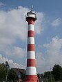
The former lighthouse, no longer available in April 2018

An auxiliary fire in April 2018

Construction site under fire in Glückstadt in May 2018
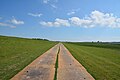
The construction road made of steel plates in front of the dike
.jpg)


See also
Web links
- Russ Rowlett: Lighthouses of Germany: Hamburg and the Elbe ( English ) In: The Lighthouse Directory . University of North Carolina at Chapel Hill . Retrieved November 7, 2017.
- Russ Rowlett: Lighthouses of ( English ) In: The Lighthouse Directory . University of North Carolina at Chapel Hill . Retrieved November 7, 2017.
- Beacon. Hamburg Waterways and Shipping Office , accessed on June 22, 2018 .
- Leading light. Hamburg Waterways and Shipping Office , accessed on June 22, 2018 .
Individual evidence
- ↑ a b Gerd Liedtke: Light beacon Osteriff. In: baken-net. Retrieved November 7, 2017 .
- ↑ Hollerwetter lighthouse
- ↑ Steindeich lighthouse
- ↑ Lighthouse on Neuendeich is being demolished
- ↑ Glückstadt replacement lighthouse is in place