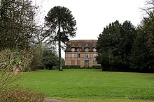
Marolles (Calvados)
| Marolles | ||
|---|---|---|
|
|
||
| region | Normandy | |
| Department | Calvados | |
| Arrondissement | Lisieux | |
| Canton | Lisieux | |
| Community association | Lisieux Normandy | |
| Coordinates | 49 ° 8 ' N , 0 ° 22' E | |
| height | 79-184 m | |
| surface | 8.4 km 2 | |
| Residents | 768 (January 1, 2017) | |
| Population density | 91 inhabitants / km 2 | |
| Post Code | 14100 | |
| INSEE code | 14403 | |
Marolles is a French commune of 768 inhabitants (at January 1, 2017) in the department of Calvados in the region Normandy (before 2016 Basse-Normandie ). The municipality belongs to the arrondissement of Lisieux and the canton of Lisieux (until 2015 Lisieux-1 ).
geography
Marolles is about 62 kilometers east of Caen . Marolles is surrounded by the neighboring communities of Ouilly-du-Houley in the north and north-west, Fumichon in the north, Piencourt in the north-east, L'Hôtellerie in the east, Thiberville in the east and south-east, La Chapelle-Hareng in the south-east, Cordebugle in the south, Courtonne-la -Meurdrac to the west and southwest and Firfol to the west.
Population development
| year | 1962 | 1968 | 1975 | 1982 | 1990 | 1999 | 2006 | 2013 |
| Residents | 462 | 412 | 394 | 493 | 565 | 625 | 643 | 758 |
| Source: Cassini and INSEE | ||||||||
Attractions
- Saint Martin Church
- Manor of Le Mont-Hérault
Web links
Commons : Marolles - Collection of images, videos and audio files

