Mittelberg (municipality of Mittelberg)
|
Mittelberg ( village ) locality district |
||
|---|---|---|
|
|
||
| Basic data | ||
| Pole. District , state | Bregenz (B), Vorarlberg | |
| Judicial district | Bezau | |
| Pole. local community | Mittelberg ( KG Mittelberg ) | |
| Coordinates | 47 ° 19 '26 " N , 10 ° 9' 15" E | |
| height | 1215 m above sea level A. | |
| Residents of the village | 1643 (January 1, 2020) | |
| Building status | 423 (2001) | |
| Postcodes | A-6993 Riezlern (Austria) , D-87569 (Germany) | |
| prefix | + 43/05517 ( Mittelberg ) | |
| Statistical identification | ||
| Locality code | 17161 | |
| Counting district / district | Mittelberg (80228 002) | |
 Valley area Mittelberg- Bödmen - Gemstelboden of support from |
||
| Source: STAT : index of places ; BEV : GEONAM ; VoGIS | ||
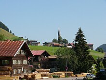
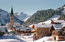
Mittelberg is a place in the Kleinwalsertal in Vorarlberg as well as a place of the community Mittelberg in the district Bregenz .
geography
The place is located 37 kilometers southwest of Bregenz , 27 kilometers south of Immenstadt and 45 km west of Imst , in the middle of the Allgäu Alps , between the northwestern Walsertal mountains and the southeastern Walsertal mountains .
The village of Mittelberg is located at around 1215 m above sea level. A. Height. It has around 150 addresses.
The village of Mittelberg comprises almost 450 buildings with around 1,500 inhabitants, which is almost 1 ⁄ 3 of the community's population. The village itself has about 1 ⁄ 3 of this , the rest is spread over some parts of the village.
Because the Kleinwalsertal / Mittelberg is a customs exclusion area and thus a German economic area, the place has not only the Austrian postcode (A-) 6993 but also a German one , namely (D-) 87569. This was retained after Austria joined the EU , but the German telephone code 08329 was closed on July 1, 2003, only 0043/5517 (from Germany, 05517 in Austria) is valid for all of Mittelberg.
Neighboring towns and cities
|
|
Hirschegg ∗ (O) |
|
|
Schoppernau (O and Gem. Schoppernau)
|

|
|
|
support
Schröcken (O and Gem. Schröcken)
|
Hochkrumbach (O, district of Warth ) |
∗∗ |
- ∗The village of Hirschegg extends in the Schwarzwassertal to the northwest
- ∗∗District Birgsau , Gem. Oberstdorf, Lkr. Oberallgäu , RegBez. Swabia , Bavaria, Germany; extends to the southeast
Parts of the village and the area of the village
The entire upper Kleinwalsertal belongs to the local area, in the valley on the left the Breitach , the main stream of the valley, behind Dürenboden , on the right behind the secondary water . This includes:
- left the Breitsach the Rotten Tobel with Rohr (both still with districts near Hirschegg ) and Ahorn ; the village of Mittelberg itself; the Rotten booms and support
- and on the right the Rotten Höfle , Schwendle (via Mittelberg, main district) and Gemstelboden
- as well as the scattered Alpenwald houses (with the individual layers of alder soil and Vorderboden ) and the village of Baad at the end of the valley - the village is usually counted as a separate part of the municipality.
In the district of Baad, Derrabach , Turabach and Bärguntbach flow together and form the Breitach, which then flows into the Iller near Oberstdorf - already in Bavaria . The Gemstelbach flows out at Gemstelboden , and the Wildenbach at Höfle , which represent the two larger side valleys in the locality. The ridge of the Walmendingerhorn ( 1990 m ) forms the northern border to the Schwarzwassertal (which belongs to Hirschegg), the rest of the boundary is the municipal boundary from the Grünhorn ( 2039 m ), with the Widderstein ( 2536 m ) towards the Hochtannberg , to the Hochgehrenspitze ( 2251 m ) in the east. The most important mountains in the town area are the bear's head ( 2083 m ) between Bärgunt- and Gemsteltal and Penalty ( 2387 m ) and Twelve ( 2224 m ) between Gemstel- and Wildental. This southern ridge is called the southeastern Walsertal mountains , the ridge Walmendingerhorn-Grünhorn belongs to the northwestern Walsertal mountains (Hoher-Ifen group).
The local area also includes the Walmendinger Horn mountain station , the Bärgunthütte , the Sterzerhütte in the rear Gemsteltal, as well as numerous Alps .
history
The place is documented around 1270-1300, as Walsers from the Großwalsertal, five originally Valais families who settled the still uninhabited Breitach valley over the Hochalppass . Mittelberg is documented during this time. It belonged to the Tannberg court , after the uprising from 1451/53 to 1500 it belonged to the Bregenz court , and in 1563 a Mittelberg court was established in Hirschegg . In 1810, under Bavarian occupation , the place came to the Bezau district court .
In 1390 a branch church was consecrated by Fischen im Allgäu , and in 1391 it was elevated to a parish church . Today's Church of St. Jodok was built in 1463 (the tower is dated 1371/74, i.e. from the porch, and there are stones with the dates 1302, 1303). In 1693/94 one could afford a more comprehensive redesign. The Mittelberg parish belonged to the Diocese of Constance until 1819 , then it came to the Diocese of Bressanone.In 1921, after the loss of South Tyrol, the Apostolic Administration Innsbruck-Feldkirch was set up, from which the Diocese of Innsbruck was established in 1964 and the Diocese of Feldkirch from this in 1968 .
Since 1891 a customs special economic zone , tourism became the main factor from the 1950s onwards, with which the place grew enormously: While the village had around 400 inhabitants around 1900, that increased to around 900 in the 1950s, and a population of just under 1500 around the year 2000, the place itself and its surroundings grew from 100 inhabitants around 1900 to around 300. In 1966 the Walmendingerhornbahn was put into operation.
The nominal municipality capital today is not Mittelberg, but Riezlern .
Economy and Infrastructure

The Walmendingerhornbahn opens up a 43 km hiking area in summer and a ski area with two additional chairlifts in winter. The valley station is not far from the center of Mittelberg at 1200 m above sea level. A. The mountain railway ends at 1946 m above sea level. A. just below the summit of the Walmendingerhorn .
Culture and sights
In the town:
- Parish church hl. Jodok with the Lourdes Chapel and the listed atonement cross nearby
- Vicarage and sacristan's house with the listed exclamation stone
- Chapel of Mary of Victory
- Listed former inn zum Mohren ( Drechsel House )
In the village:
- Kuratienkirche hl. Martin and school and chaplain house in Baad
- landmarked Walserhof and another farmhouse in Bödmen
- listed Walser house in Gemstelboden
- listed Paarhof system in Höfle
- listed Walser house in Tobel
Personalities
- Stefanie Schuster , former professional ski racer
- Ludwig Leitner , former professional ski racer
- Leo Müller , inventor (19th century)
- Resi Hammerer , only Walser medal winner at the Olympic Games in downhill skiing at the Olympia 1948 in St. Moritz.
Web links
- Mittelberg (1215 m) , on kleinwalsertal.com (tourist office) → Orte
proof
- 80228 - Mittelberg. Community data, Statistics Austria .
-
↑ a b Battle over postcodes. A valley wants to stay German , n-tv online, April 18, 2006;
Swiss Post confirms that the postcode will be retained ( memento of December 31, 2011 in the Internet Archive ) , kleinwalsertal.com, News , July 8, 2006 (no longer available, archived on archive.is ( memento of December 31, 2011 in the Internet Archive )). -
↑ Federal Network Agency Lot Size Directory ONB: Special determinations in the local networks - notification of the shutdown of the German area codes on July 1, 2003 ( memento of April 11, 2013 in the Internet Archive ), bundesnetzagentur.de;
Austrian community fights for German area code. Telekom wants to turn off area code 08329 on July 1st . By dpa / Marie-Anne Winter, teltarif.de ›Messages› Fixed line ›Area code› "Dispute" , June 29, 2003. - ^ Kurt Klein (edit.): Historical local dictionary . Statistical documentation on population and settlement history. Ed .: Vienna Institute of Demography [VID] d. Austrian Academy of Sciences . Vorarlberg , Mittelberg: Mittelberg with Mayor Mittelberg , S. 43 ( online document , explanations . Suppl . ; both PDF - oD [updated]).


