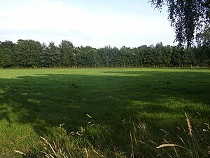
Garbeeke nature reserve
|
Garbeeke nature reserve
|
||
|
Garbeeke nature reserve |
||
| location | South of Bassum in Lower Saxony Diepholz | |
| surface | 60.0 ha | |
| Identifier | NSG HA 193 | |
| WDPA ID | 318424 | |
| Geographical location | 52 ° 50 ' N , 8 ° 42' E | |
|
|
||
| Sea level | from 38 m to 50 m | |
| Setup date | 08/19/1999 | |
| administration | NLWKN | |
The Garbeeke nature reserve is a nature reserve in the Diepholz district in Lower Saxony .
description
The 60 hectare nature reserve with the sign NSG HA 193 is located directly south of the urban area of Bassum . It encompasses the course of the Garbeeke (the approx. 3 km long stream is also called Garbruchsgraben ) from its source area to the confluence with the “ Klosterbach ” including the valley. Alder- broken forest, alder- ash forest and oak- mixed forest grow on the moist sites . The individual biotope types include forest areas and unused swamp areas , which should develop as naturally as possible without being disturbed. Grassland is used in some areas .
history
By ordinance of July 15, 1999, the "Garbeeke" area was declared a nature reserve. The district of Diepholz is responsible as the lower nature conservation authority.
See also
Web links
- "Garbeeke" nature reserve in the database of the Lower Saxony State Office for Water Management, Coastal and Nature Conservation (NLWKN)
Individual evidence
- ↑ Map on a scale of 1: 5,000 ( memento of the original from June 26, 2015 in the Internet Archive ) Info: The archive link was inserted automatically and has not yet been checked. Please check the original and archive link according to the instructions and then remove this notice. , Natur-erleben.Niedersachsen.de


