Palazinges
|
Palazinges Palajanjas |
||
|---|---|---|

|
|
|
| region | Nouvelle-Aquitaine | |
| Department | Corrèze | |
| Arrondissement | Brive-la-Gaillarde | |
| Canton | Midi Corrézien | |
| Community association | Midi Corrézien | |
| Coordinates | 45 ° 10 ′ N , 1 ° 42 ′ E | |
| height | 306-551 m | |
| surface | 5.25 km 2 | |
| Residents | 153 (January 1, 2017) | |
| Population density | 29 inhabitants / km 2 | |
| Post Code | 19190 | |
| INSEE code | 19156 | |
Palazinges ( Occitan Palajanjas ) is a French municipality with 153 inhabitants (at January 1, 2017) in the Correze in the region Nouvelle-Aquitaine ; it belongs to the Arrondissement of Brive-la-Gaillarde and the canton of Midi Corrézien . The inhabitants call themselves Palazingeois (es).
geography
Tulle , the prefecture of the department, is about 20 kilometers to the northeast, Brive-la-Gaillarde about 19 kilometers to the west and Beaulieu-sur-Dordogne about 33 kilometers to the southeast. The Coiroux , a tributary of the Roanne , forms the municipal boundary with Aubazines in the north.
Neighboring communities
Neighboring municipalities of Palazinges are Aubazines in the north, Le Chastang in the east, Beynat in the southeast, Albignac in the south and southwest and Dampniat in the west and northwest.
traffic
Junction 49 for Autoroute A20 is about 20 kilometers northwest.
coat of arms
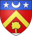
Description : A pressed golden rafter on red , underneath a golden oak on a silver terrace, in the shield head on blue a silver crescent moon lying between two silver stars .
Population development
| year | 1962 | 1968 | 1975 | 1982 | 1990 | 1999 | 2007 | 2016 |
| Residents | 83 | 95 | 99 | 100 | 115 | 103 | <148 |
