Lanteuil
|
Lanteuil Lantòl |
||
|---|---|---|

|
|
|
| region | Nouvelle-Aquitaine | |
| Department | Corrèze | |
| Arrondissement | Brive-la-Gaillarde | |
| Canton | Midi Corrézien | |
| Community association | Midi Corrézien | |
| Coordinates | 45 ° 8 ′ N , 1 ° 40 ′ E | |
| height | 200-400 m | |
| surface | 22.68 km 2 | |
| Residents | 507 (January 1, 2017) | |
| Population density | 22 inhabitants / km 2 | |
| Post Code | 19190 | |
| INSEE code | 19105 | |
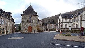
 Saint-Côme and Saint-Damien Church; right town hall and school building |
||
Lanteuil ( Occitan Lantòl ) is a French commune with 507 inhabitants (as of January 1, 2017) in the Corrèze department on the western edge of the Massif Central . The inhabitants call themselves Lanteuillois (es).
geography
Tulle , the prefecture of the department, is about 26 kilometers northeast, Brive-la-Gaillarde about 10 kilometers northwest and Beaulieu-sur-Dordogne about 29 kilometers southeast. The Roanne and the Loyre , two left tributaries of the Corrèze , flow through the municipality.
Neighboring communities
Neighboring municipalities of Lanteuil are La Chapelle-aux-Brocs and Dampniat in the north, Albignac in the northeast, Beynat in the east, Lagleygeolle and Noailhac in the south, Turenne in the southwest and Cosnac in the west.
traffic
Junction 52 to Autoroute A20 is about 18 kilometers southwest.
coat of arms
Description : In red four golden beams and the golden right Obereck a red lion .
Population development
| year | 1962 | 1968 | 1975 | 1982 | 1990 | 1999 | 2007 | 2016 |
| Residents | 523 | 469 | 427 | 406 | 431 | 478 | 500 | 522 |
Attractions
- Castle of Lanteuil from the 15th and 16th centuries, monument historique since April 15th 1987
- Saint-Côme and Saint-Damien Church
Web links
Individual evidence
- ↑ Entry no. PA00099787 in the Base Mérimée of the French Ministry of Culture (French)
